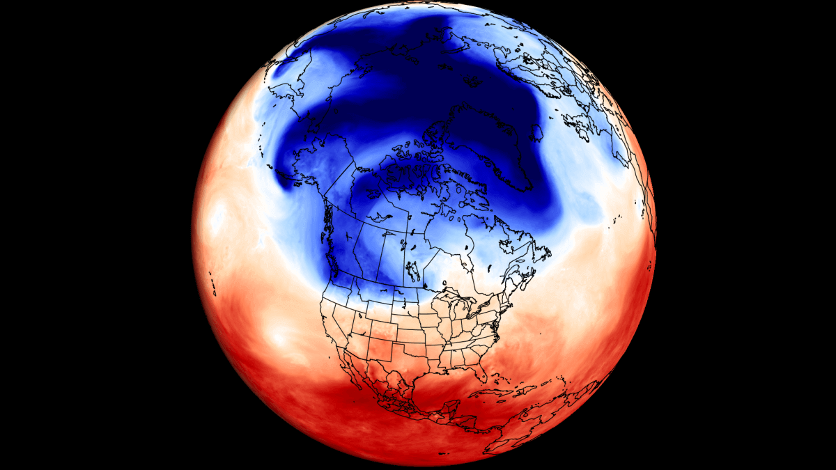
The final Summer 2024 forecast shows a strong atmospheric pattern, indicating a disturbance from the emerging cold La Niña phase in the Pacific Ocean. This region of the Pacific has a known impact on the Atmosphere and weather patterns and is on the verge of a major shift to a cold phase right during the Summer season.
This region of the Pacific is called ENSO. It is an ocean anomaly that changes between warm and cold phases on the ocean surface and below. For the past months, we were in a warm phase (El Niño), but now we are in a rapid transition into a cold phase called La Niña.
We will look at the latest disruption of the ocean anomalies across the ENSO regions and how such transitions have impacted Summer weather patterns in the past. We will also compare that data with the latest long-range forecasts and see how the Summer is expected to unfold across North America and Europe.
IT COMES FROM THE OCEAN
A strong driver of the weather patterns this past winter and early spring was El Niño, a warm phase of an oceanic anomaly called ENSO. It is found in the equatorial Pacific and alternates between warm and cold phases, as we mentioned already.
Each phase has a different impact on the pressure patterns and the resulting weather worldwide. So, the transition periods from one phase to another can also be very dynamic and have their specific large-scale weather influence.
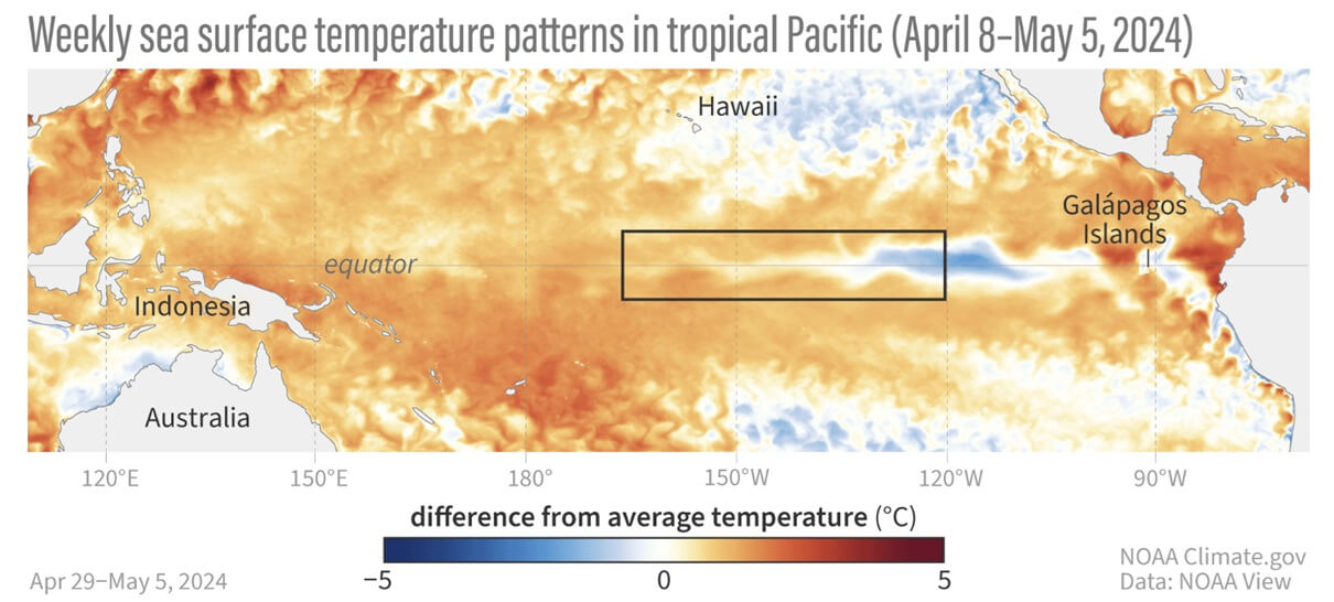
Below is the latest ocean temperature analysis. You can see warm anomalies over the Equator with the black box marking the main ENSO region. But you can see that cold areas are already emerging and spreading on the surface.
The image below shows the progress of ocean temperature anomalies across the ENSO regions. Peak warm anomalies were recorded in December with the El Niño. But a rapid drop in ocean temperatures began early this year, with the whole region expected to turn into a negative cycle during summer.
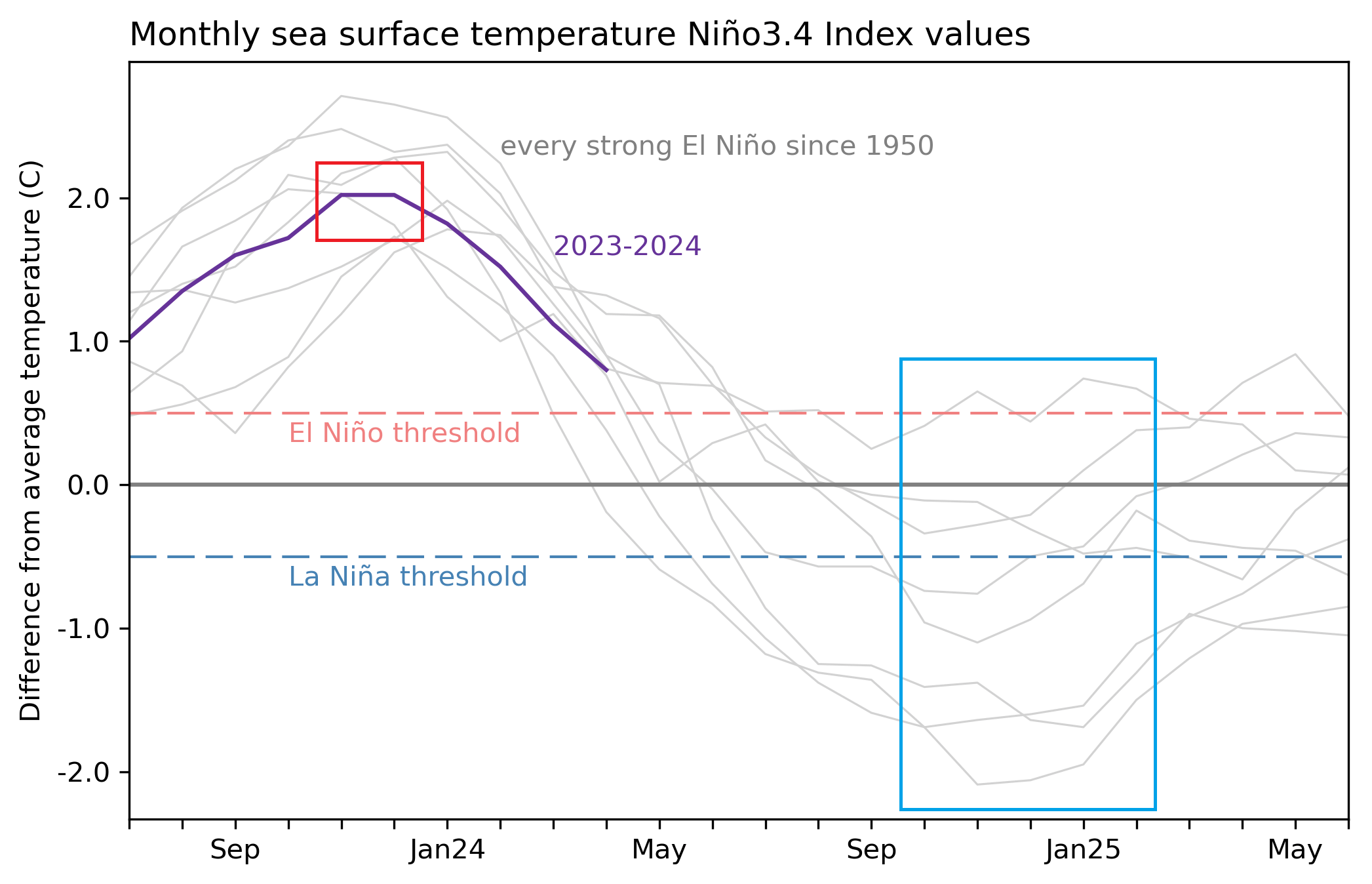
You can see the thin gray lines in the image above. Those are past strong El Niño events, and you can see how they unfolded. Most ended up in a neutral phase or in a moderate to strong La Niña event by next winter.
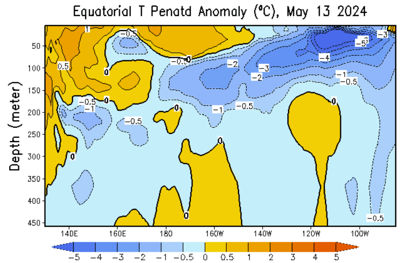
The shift from one phase to another mostly starts below the ocean surface. With the aid of the trade winds and ocean currents, temperature anomalies at depth move from west to east, eventually coming to the surface over the eastern Pacific.
In the image below, you can see the latest analysis of the subsurface ocean temperatures in the tropical Pacific. You can see a deep cold anomaly across the ENSO regions in the east. It is already rising to the surface, which is the usual process to start a La Niña.
This process can be seen in the video below, which shows the ocean temperature anomaly for the past two months. You can see the rapid cooling and the shift from the dominant warm anomalies to the emerging cold areas in the ENSO regions.
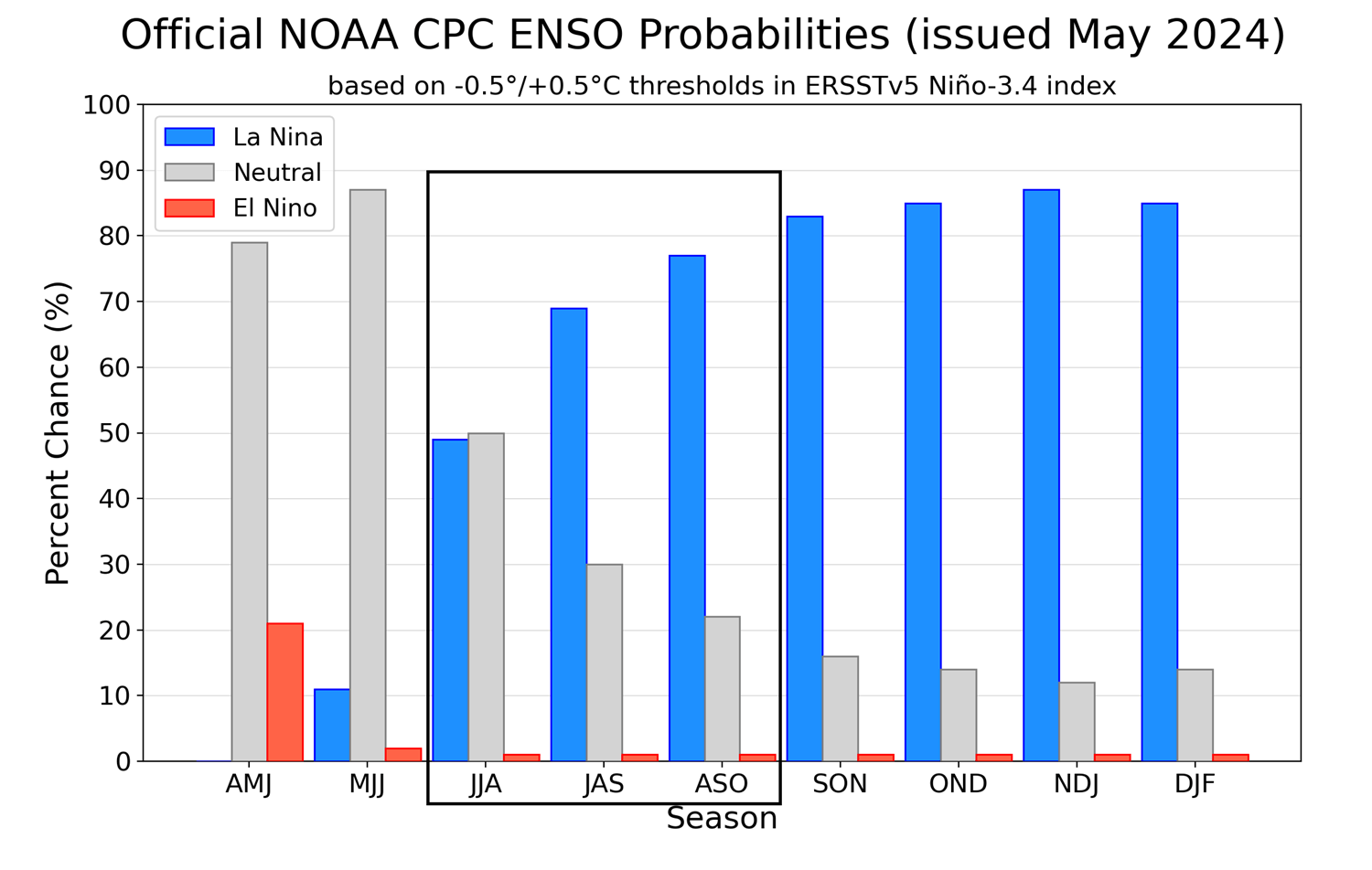
Below is a forecast graphic from CPC that shows the long-range outlook for the main ENSO region. You can see the seasonal probability, which shows the rapid end of the warm phase and the emergence of a cold phase during summer, lasting into next winter 2024/2025.
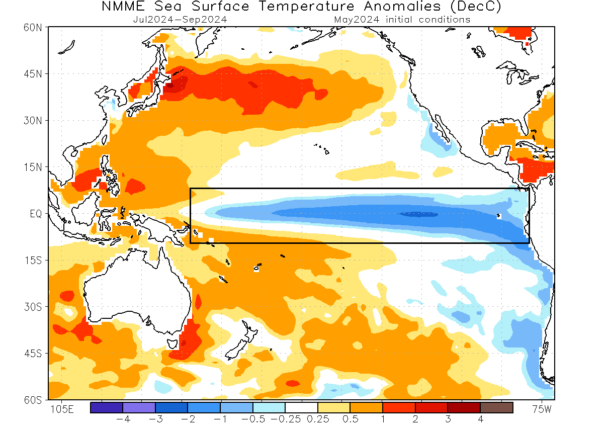
Looking at the long-range ocean anomaly from the NMME forecast, you can see an area of cold ocean surface anomalies spanning the entire tropical Pacific by late summer and early autumn. An event of this magnitude is strong enough to have a significant atmospheric response during the winter of 2024/2025.
Based on all this data, we know that the oceans are currently in a disrupted state with the La Niña ready to emerge. But, such large events tend to work on longer time scales. This means that it takes some time for the atmosphere to respond to these oceanic changes.
For this reason, the summer of 2024 will be in the middle of the transition period from one ENSO phase to another, likely creating some unusual anomalies in the process.
THE PAST AND FUTURE WEATHER
If we want to understand what such a shift means for the atmosphere, we can look at past events and how they impacted the weather. For this reason, we produced a few images to try and find a common weather pattern that resulted from these shifts.
The image below shows surface pressure during some past La Niña summers. You can see that a surface high-pressure anomaly in the Pacific is the usual La Niña signature during summer. We can use this to compare with the latest forecast/analysis data and estimate the spreading influence of the new cold ENSO phase.

Looking at the latest surface pressure anomaly forecast for summer 2024, we can see a very similar pattern over the tropical Pacific. A high-pressure anomaly is dominant in the eastern Pacific, indicating a growing La Niña influence. This means that during summer, at least the tropical atmosphere will already be in the new La Niña cycle.
Using this information, we know that the La Niña influence will rapidly expand over the summer. So we decided to look into the past data again, and we found several years that had a similar transition from a winter El Niño into a summer La Niña.
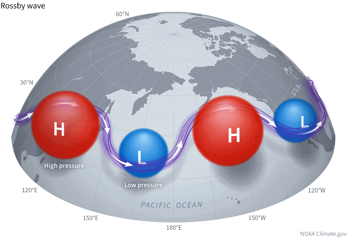
To better understand this data, we can imagine the weather patterns and pressure systems behaving like waves, called the Rossby Waves. They are pairs of pressure systems linked together by the jet stream. The image below by NOAA shows an example of Rossby waves.
Below is the combined summer pressure anomaly for all the transition years we found in the past. You can see a perfect example of Rossby waves, with a very dynamic pattern of high and low-pressure anomalies working in pairs. The most obvious is a train of pressure systems from the Pacific over the United States into the Atlantic and Europe.
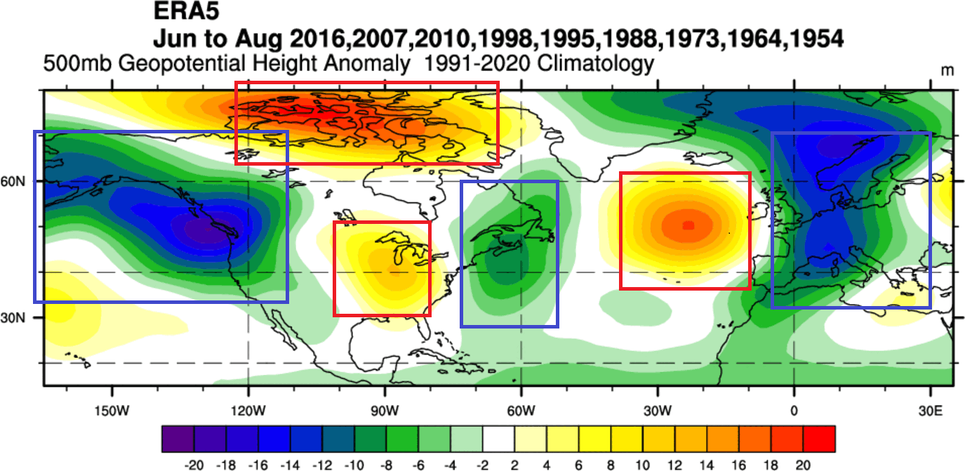
A notable pair/wave is the low-pressure area in the northern Pacific and high-pressure over the United States and Canada. Another strong Rossby wave is a high-pressure zone over the northern Atlantic with a low-pressure tendency over Europe.
The temperature anomaly for this transitional pattern shows above-normal temperatures over much of the central and eastern United States and southern Canada. But over Europe, we can actually see a trend for lower temperatures than normal.
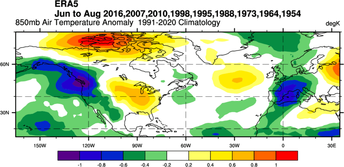
A disclaimer: some of the cold anomalies in the image above had resulted from using summers over 50 years ago in this composite when the overall climate was a bit cooler than today.
Now, we have an idea of what to expect for this summer. But while this past analysis can show us what to look for, each year has its own differences, so we will look at the latest model forecasts, based on the actual oceanic and atmospheric data.
SUMMER 2024 FINAL LONG-RANGE FORECAST
We will examine the forecast trends from the ECMWF, UKMO, and the NMME models. We like using different forecasting systems, as it helps us to see more potential scenarios and see how well the models agree on a certain outcome.
ECMWF is usually the better long-range model, so we tend to start with its forecast. Generally, this model is at the top as far as “reliability” goes. But no long-range/seasonal forecasting system can be called “reliable”. This is because we only look at trends and how the weather patterns are evolving on a large scale and over longer periods.
The forecast period we will focus on in all models is June-July-August (JJA 2024). This covers the meteorological Summer, which is the warmest part of the year in the Northern Hemisphere.
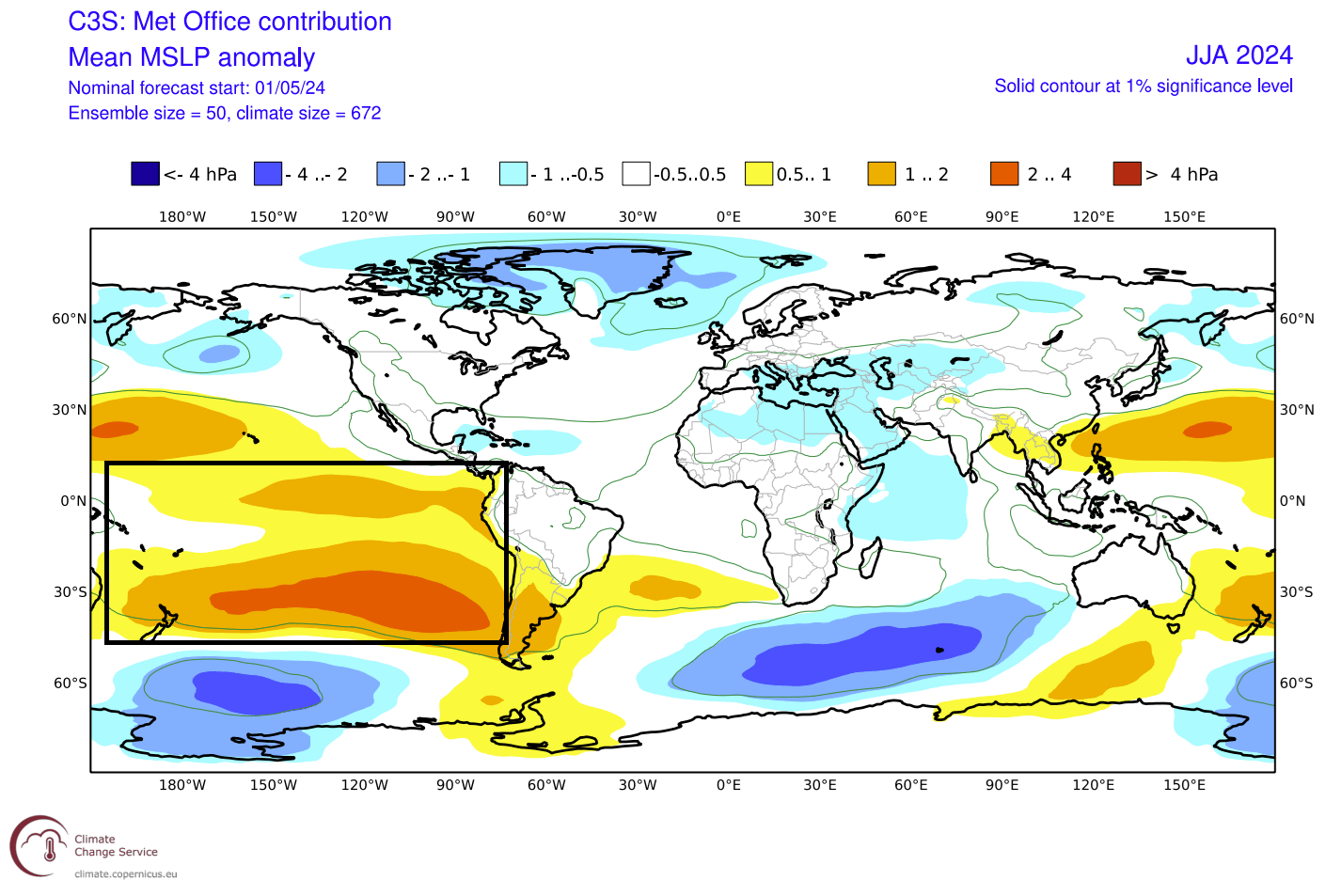
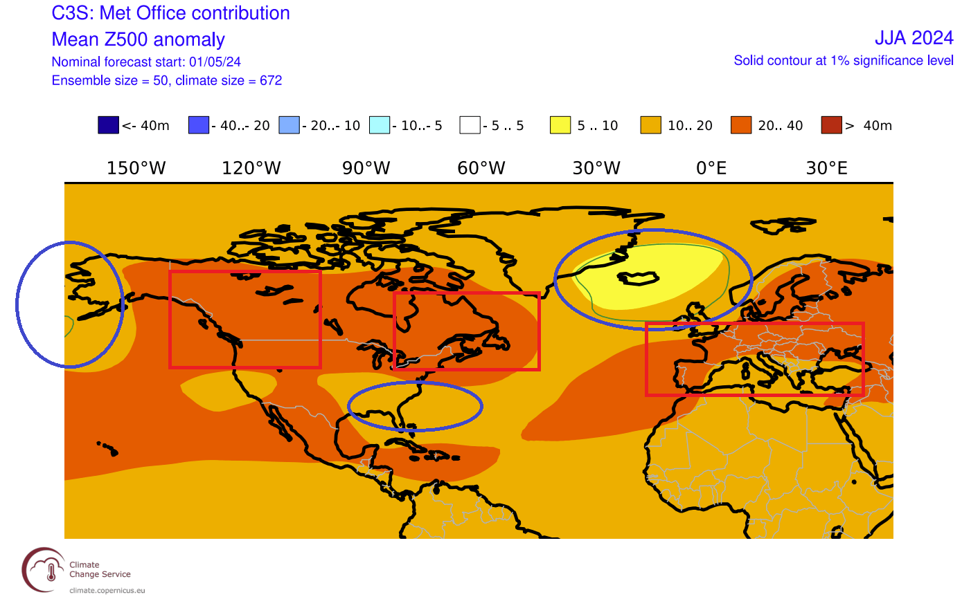
First, we have the pressure pattern forecast below. It is similar to the analysis we did above for past years, with a pair of low/high-pressure anomalies over the northeast Pacific and the United States. The difference is the high-pressure anomaly over the northeastern United States and southeastern Canada, where the past data suggests a low.
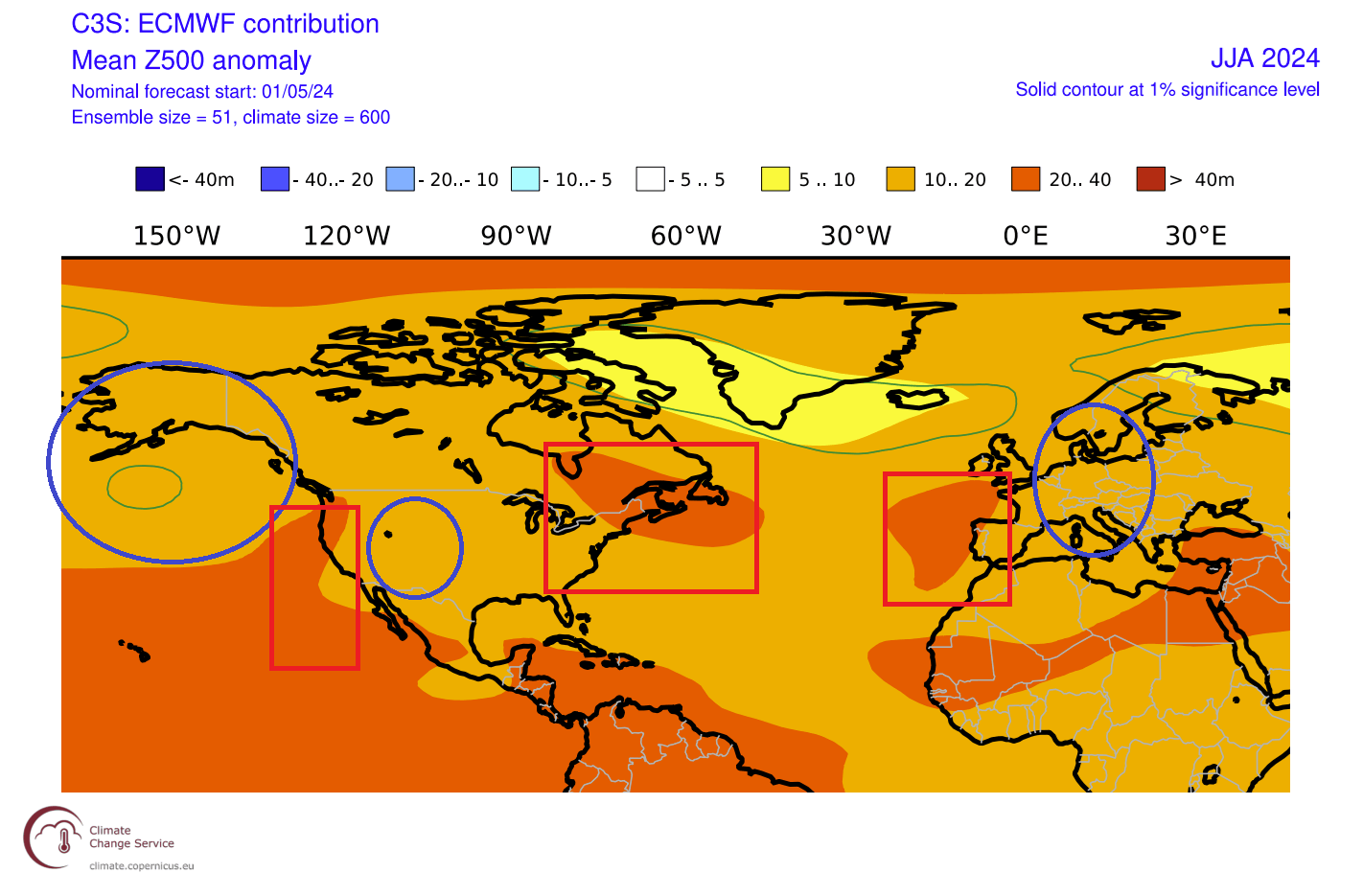
Another such pair is the high-pressure over the eastern Atlantic and a low-pressure indication over Europe and southern Greenland.
With the change in the pressure anomaly over the northeastern United States, the temperature forecast in the lower atmosphere is different from past patterns. We do not see any cold anomalies, as this is just a modeled forecast. But we usually look at patterns where the anomaly is higher than the surrounding area.
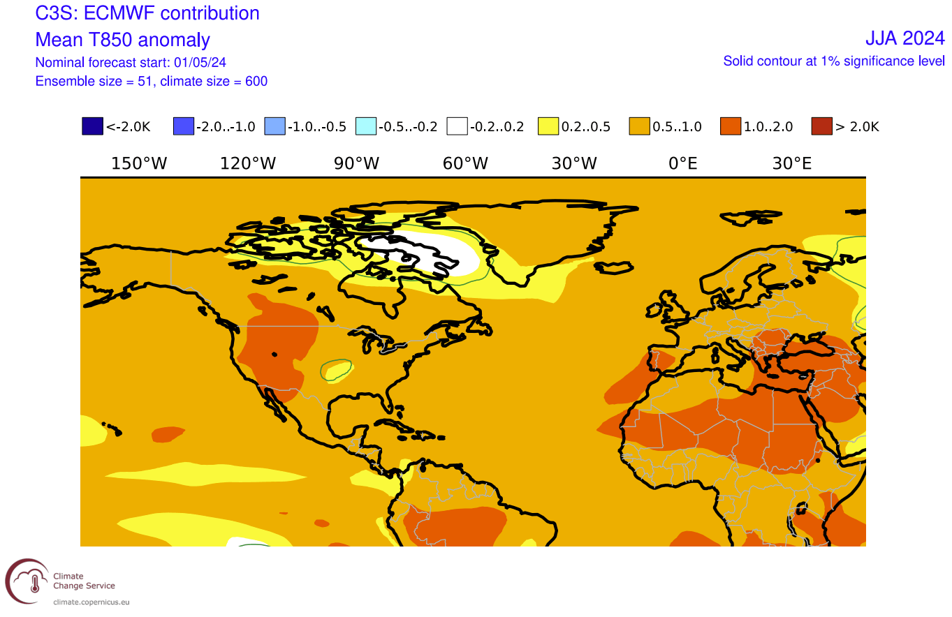
The signals in this forecast show an area of above-normal temperatures and a higher tendency of heatwaves over the western United States and up into southwestern Canada. An interesting area of reduced heat anomaly is indicated over the central Plains. Another warm anomaly area is over both southern ends of Europe.
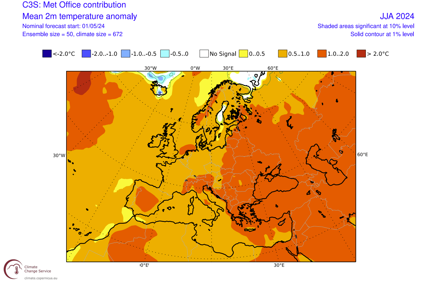
Looking closer at the surface temperature pattern over Europe, we see warmer-than-normal weather over a large part of the continent. The strongest anomalies and most heatwave tendencies are over the east/central and southern parts of the continent. This is similar to the forecast issued last month.

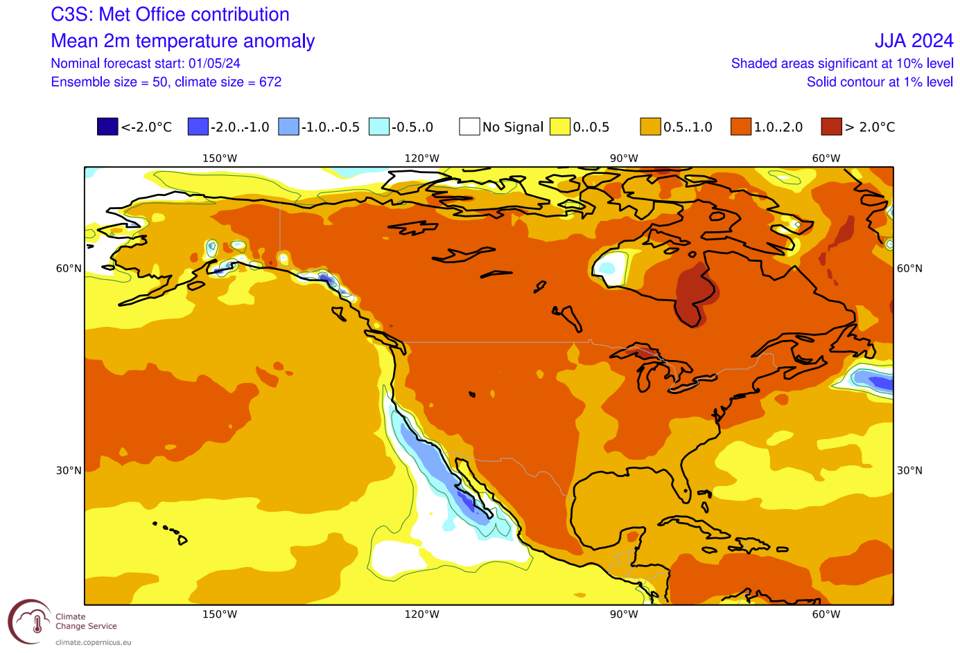
Over North America, we can see mostly warm anomalies over the western United States, expanding into southwestern Canada. This latest run of forecasts has reduced the warm anomaly over the Midwest and even introduced an interesting area of “normal” temperatures across the south/central Plains.
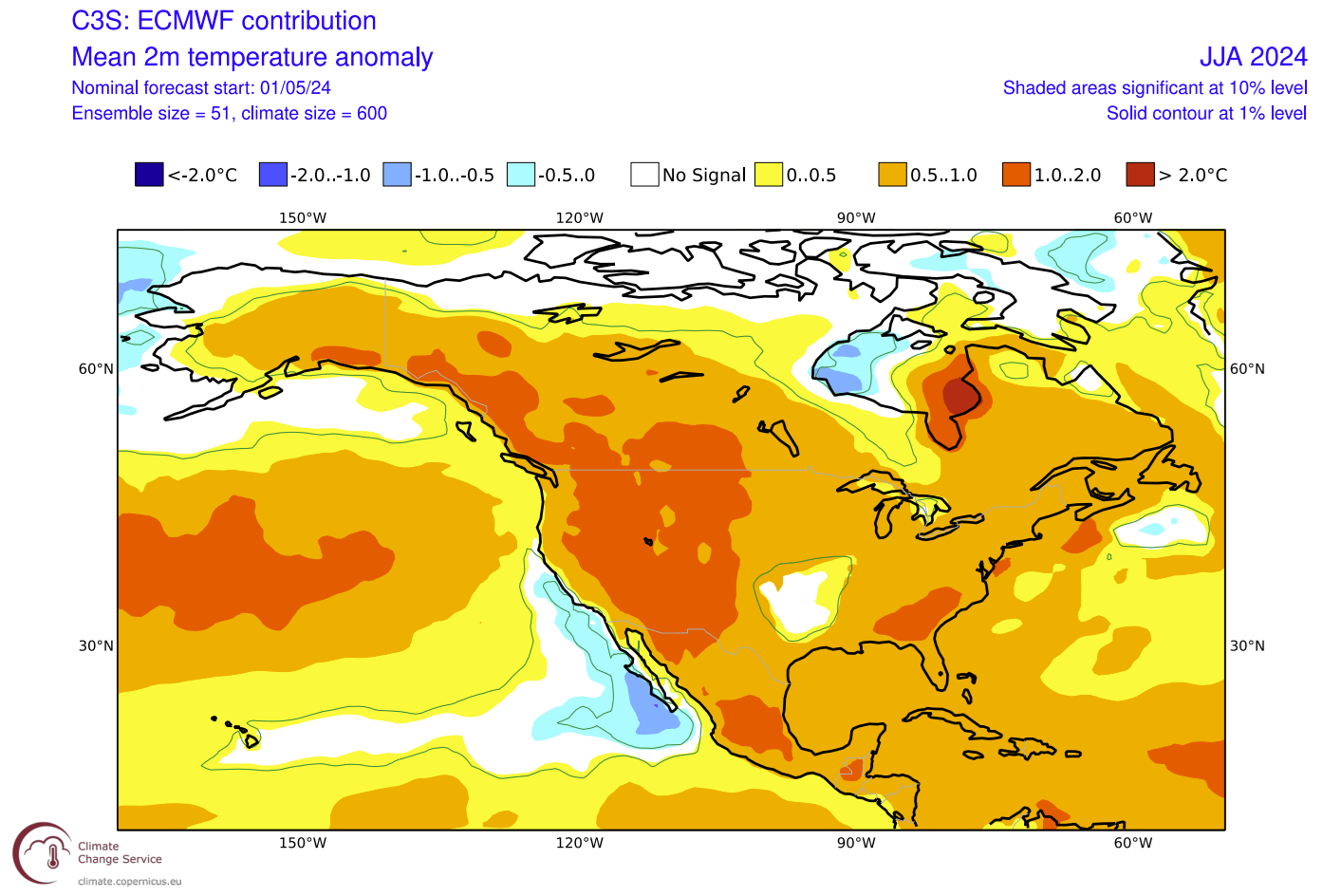
This shows a high tendency for prolonged heat events over the western United States and over the Southeast. It will be interesting to see how/why this area of normal temperatures is forecast over the Plains, but it is perhaps unusual to see it in a La Niña summer.
Canada is also warmer than normal in the eastern half of the country under the impact of the high-pressure area.
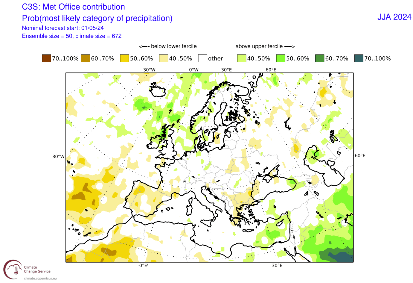
Looking at precipitation, we can see mostly normal precipitation forecast over mainland Europe, with no strong drought areas visible in this forecast. More rainfall is forecast over the northern parts, again due to the lower pressure and more unstable weather in the westerly winds.
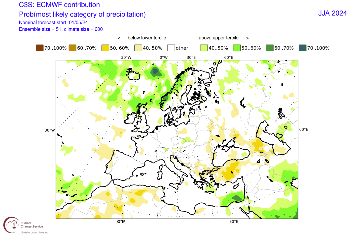
Overall, there is an indication of La Niña’s influence over Europe, which is usually hard to track, even during winter. But, there are some visible patterns that are similar to the expected pressure anomalies for a La Niña summer.
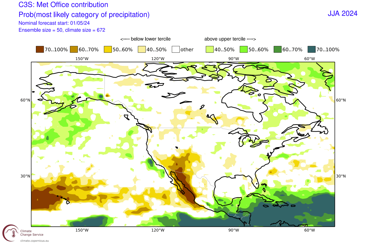
The precipitation forecast for North America also shows less rainfall over the western parts of the United States and parts of western Canada. More rainfall is expected across the Midwest, East Coast, and over the Plains.
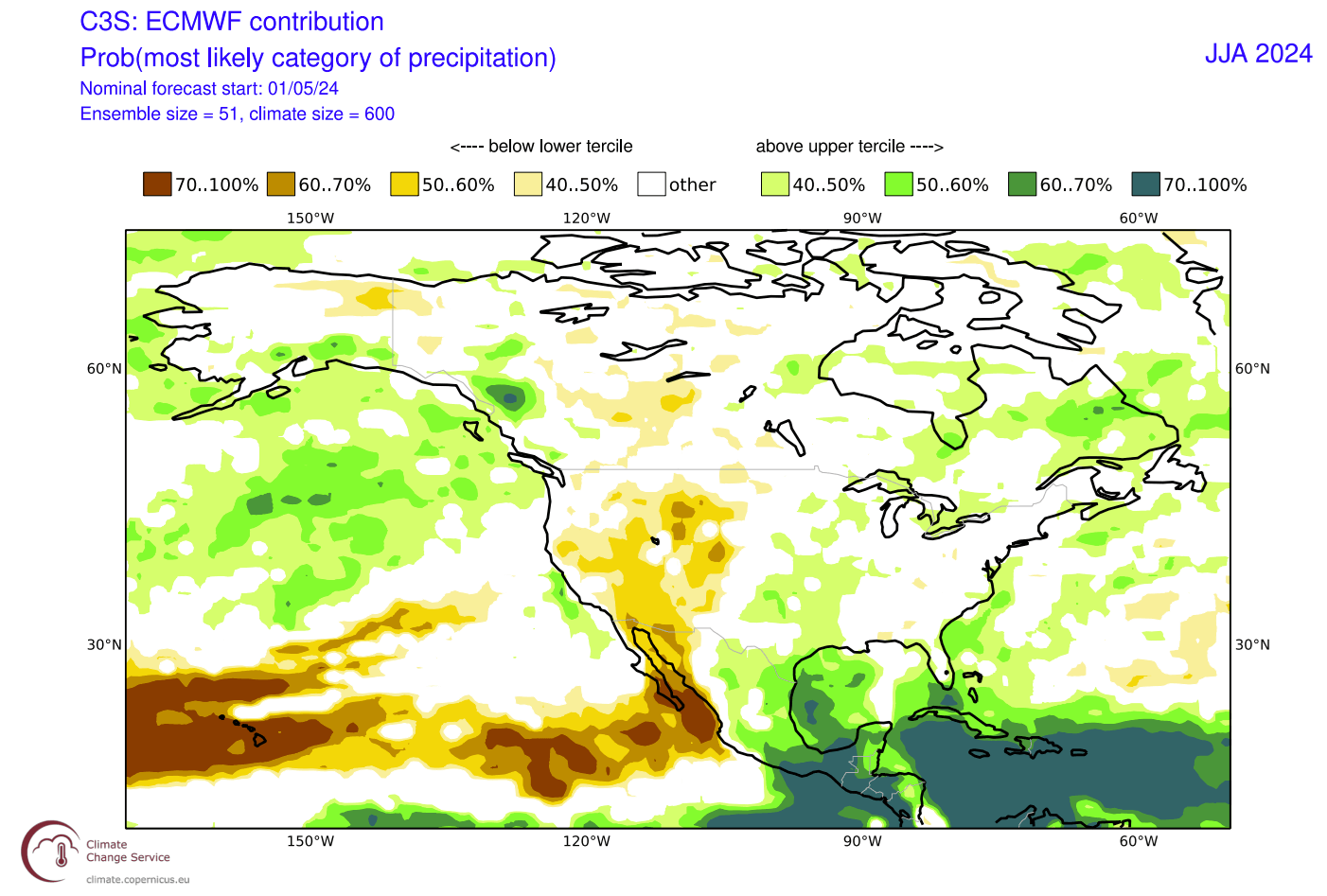
We also saw a temperature anomaly forecast over the Plains, which suggests a bit more unsettled weather over the region.
But if we know how the pressure pattern looks, we know that the south/central Plains and up towards the Midwest will be under a more southerly to southwesterly flow. That brings moisture, which is supportive of thunderstorm formation and more rainfall.
So when we have an overlap of increased rainfall and increased temperatures, like over the Midwest, it can be seen as an increased thunderstorm activity.
Overall, the summer weather pattern over North America does look to have a visible La Niña signature in the weather patterns. It makes sense, as North America is much closer to the source region in the Pacific, so it is expected to feel the early changes of the new La Niña emerging.
UKMO SUMMER FORECAST UPDATE
The second model of choice is from the United Kingdom Met Office, mostly called UKMO.
Below is the pressure anomaly forecast, and it shows a slightly different pattern to the ECMWF above. It shows a high-pressure area over a larger part of Canada and the northwestern United States, extending into the Atlantic.
The low-pressure area over the United States is focused more on the southeastern part of the country. Over Europe, the low-pressure zones are also separated into two regions: low to the north and a high-pressure zone over the mainland, unlike the ECMWF’s more west-east (high-low) approach.
Looking closer at the surface temperature pattern over Europe, it is similar to the ECMWF. Here we see the main heatwave tendency more towards the east and south. Some western and central parts still show stronger warm anomalies, indicating a higher frequency of heatwaves in these regions.
Due to the large high-pressure zone over the Pacific Northwest and eastern Canada, we can see a large area of strong warm anomalies over the majority of North America. Peak anomalies are found in the upper Midwest and southeastern Canada. Southern parts of the United States do not show the strongest anomalies, as it is under a low-pressure tendency, across a similar area as in the ECMWF forecast.
This shows a high tendency for prolonged heat events over the western half of the United States and over the Midwest, with the heat waves expanding across the border into southeastern Canada.
The precipitation forecast shows normal to drier conditions over far western and southern parts of Europe. Only a slight increase in rainfall is forecast over the central parts. More rainfall is forecast for the northern parts under the influence of a broader low-pressure zone.
The precipitation forecast for North America shows less rainfall over the southwestern and northwestern United States, just like the ECMWF. Less rainfall is also forecast over southern Canada. More precipitation is forecast for parts of the Midwest, around the Great Lakes, and over the northeastern United States.
Combined with the strong temperature anomalies over most of the United States, this forecast shows a strong drought potential for the southwestern United States.
NORTH AMERICAN FORECASTING SYSTEM
In addition to the European models, we like to use the North American Multi-Model (NMME) forecast. It combines several different long-range solutions from forecasting centers across North America into one single forecast.
The North American temperature forecast below is somewhere between the ECMWF and UKMO. It shows that the summer will be warmer than normal over the Midwest, like the UKMO, and over the western United States, with a gap in warm anomalies across the plains, like the ECMWF.
Another area of strong warm anomalies is forecast over far western and far eastern Canada, with a neutral zone over the south/central part of the country.
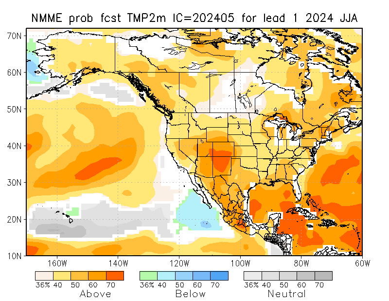
The NMME precipitation forecast for North America shows less rainfall than normal over the western United States, the central plains, and parts of the Midwest. More rainfall is forecast over the far northern United States, the deep south, and over the east coast.
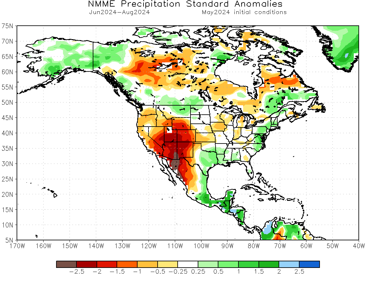
Less precipitation is also forecast over west/central Canada and parts of southern and eastern Canada. More rainfall is forecast for the far southwestern and southeastern parts of Canada, across the northwest, and also over Alaska.
The potential for drought conditions in the southwestern United States is higher than usual. The other two modeling solutions also show this, which increases the confidence in this scenario.
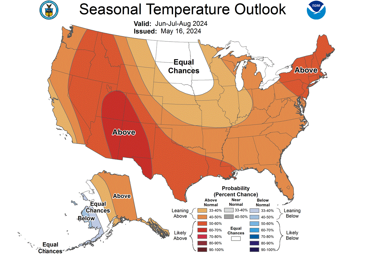
SUMMER 2024 LATEST OFFICIAL FORECAST
The NOAA official Summer temperature outlook shows that most of the United States is expected to be warmer than normal, apart from the northern Plains. The core warm anomalies are so far focused on the western parts of the United States and the northeast. Higher temperatures than normal over the west are also indicated in all model forecasts above.
The official Summer precipitation outlook is also close to the model forecasts. We see an equal-to-higher probability for more precipitation over the eastern and southeastern parts of the United States.
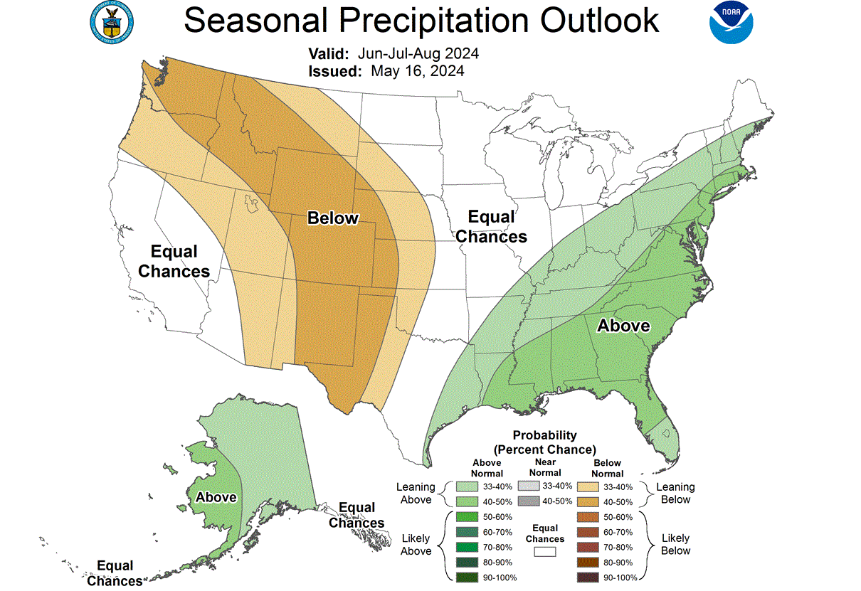
All models also show drier conditions over the western and southwestern United States, so this official forecast agrees with that scenario. However, there is less agreement over the northwestern United States, where less precipitation is only shown in the official outlook but not in the models.
We will release regular updates as fresh forecasts and data are available. So make sure to bookmark our page. Also, if you have seen this article in the Google App (Discover) feed, click the like button (♥) there to see more of our forecasts and our latest articles on weather and nature in general.
SEE ALSO: