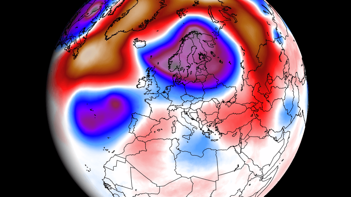
The June weather forecast for Europe shows a more dominant high-pressure area over the southern and eastern parts of the country, with a low-pressure anomaly more dominant over the northwest. Warmer than normal weather will stay over southern east-central and northern Europe for most of the month, while a more unsettled pattern is called for the northwest.
As the meteorological spring has come to an end, we will first take a quick look at the atmospheric patterns for the past season. Then, we will do a weekly forecast breakdown of the weather patterns over Europe for the coming month.
AS SEASONS CHANGE
The meteorological summer begins on June 1st. Meteorological seasons are 3-month periods that separate the year into four seasons based on the temperature and weather patterns.
In the Northern Hemisphere, June-August is the warmest period of the year, while December-February is the coldest period, covering summer and winter, respectively. The spring and autumn are the two transition periods in between.
So, as the meteorological spring comes to an end, we can first quickly look back at the weather patterns using the analysis data from the NOAA Physical Science Laboratory.
The image below shows the spring 500mb pressure anomaly. You can see a large high-pressure area over Scandinavia and eastern Europe. A low-pressure anomaly was present over the Atlantic, reaching into Western Europe.
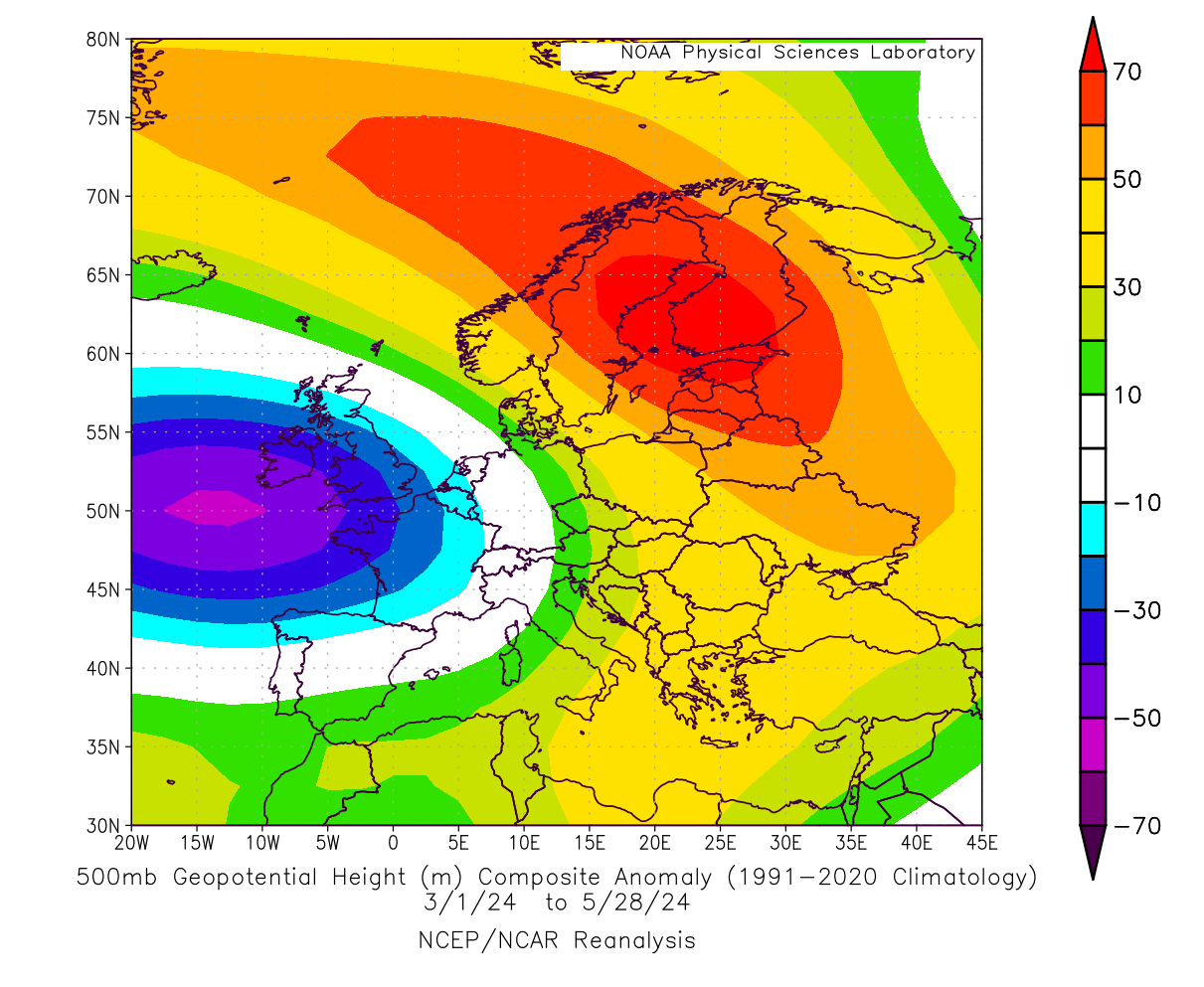
A low-pressure area spins counterclockwise, which means it produces a southerly flow on its front (east) side and a northerly flow on its back (west) side. This usually means warmer air transport ahead of the low area and cooler air behind the low.
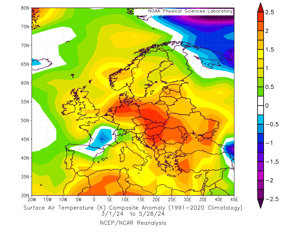
Below is a temperature anomaly analysis, which shows the effects of the low-pressure area over the west. Warmer-than-normal temperatures were present over much of central and eastern Europe and under the southerly flow, amplified between the pressure difference over western and northern Europe.
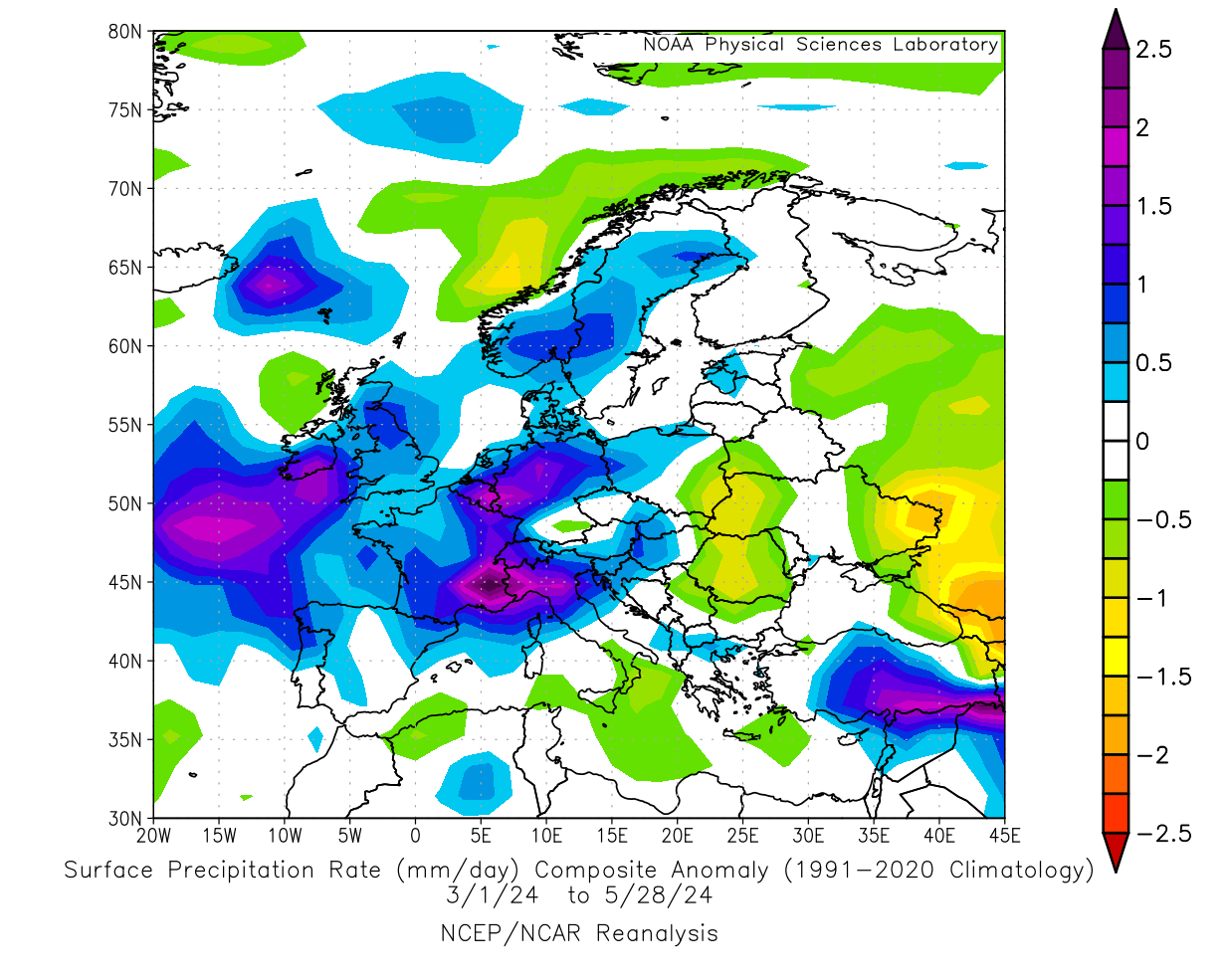
Pressure patterns also drive precipitation. The analysis below shows that this spring, there was more rainfall over western and central Europe. Again, this is due to the pressure difference between the west and the north, creating a warmer and moist southerly flow, creating more clouds and precipitation.
One of the drivers behind the overall spring weather patterns in the Northern Hemisphere was the weakening El Niño anomaly in the Pacific Ocean. El Niño is the warm ocean phase in the tropical Pacific. But in the latest analysis below, you can see this region starting to shift into a cold phase called La Niña.
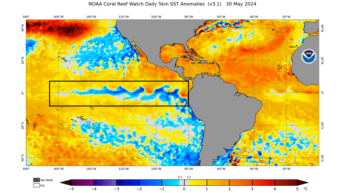
In the video below, you can see the spring shift from the warm ocean anomalies into more cold areas starting to appear. This was the rapid breakdown of the warm ENSO phase.
This is a new cold ocean ENSO phase that is currently developing. It will become more important for weather patterns as we move into summer and especially later towards winter. We will cover this in more detail in our upcoming ENSO update article, but it is worth mentioning as it is an important factor and a big weather driver in 2024 so far.
Europe is perhaps not as directly affected by the ENSO anomaly as North America, but we can still feel the impacts of the La Niña/El Niño as they change global weather patterns.
EARLY JUNE WEATHER
We will look at the June weather trends using the latest ensemble guidance from the ECMWF forecasting system. Graphics are provided by weathermodels.com using a commercial forecasting license and some from TropicalTidbits.
Looking at the pressure anomaly forecast for the first week of June, you can see a positive NAO pattern, with the amplified westerly flow into Europe. There is a low-pressure transit over central Europe, but the east and west are under high-pressure anomalies.

As mentioned, the NAO pattern describes the pressure difference between Iceland and the Azores. A positive NAO means low pressure over Iceland and a high over the Azores, as you can see in the image above.
As the pressure systems spin in the opposite direction, they act like a “pump”, bringing a strong westerly flow into western, central, and northern Europe.
This can be seen in the temperature anomaly forecast below for the same period. There is a strong warm anomaly over Scandinavia and the northeast, as the westerly and southwesterly winds bring a warmer airmass than normal into the region.
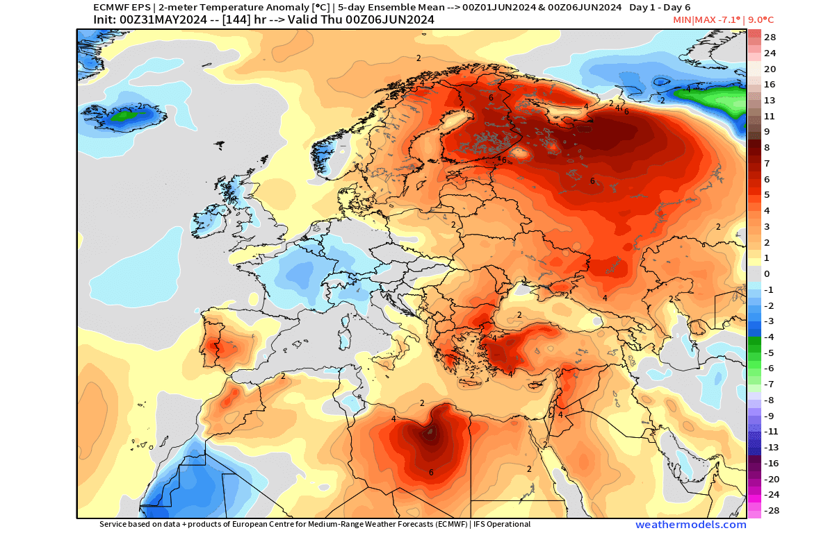
You can see a cool anomaly over the UK, Ireland, and parts of west-central Europe. This is due to the mild Atlantic airmass being driven into the region.
Below are daytime temperatures for early next week, reflecting the temperature anomaly trends above. You can see temperatures well into the 20s, reaching far up into Scandinavia. At the same time, the mild Atlantic airmass keeps the temperatures below 20°C over west-central Europe.

In the first week of June, temperatures will exceed the 30s in the southeast and will also start to rise over 30°C in Spain and Portugal.
Looking at the precipitation forecast, you can see increased rainfall potential over northern and parts of central Europe. Less rainfall is forecast over the UK, Ireland, western and southern Europe.

JUNE FORECAST – WEEK 2
The weather pattern in the second week is forecast to be similar to that in the early month. The main difference is a stronger high-pressure ridge over central and eastern Europe. The low-pressure area remains over northwestern Europe.

This promotes a more westerly to southwesterly flow over the continent and tends to keep temperatures down over the northwest and warmer over the central parts and the southeast.
The temperature forecast below shows this. The milder Atlantic airmass keeps temperatures in check over Iceland, the UK, Ireland, and parts of Scandinavia and Western Europe. A warmer airmass will spread into central, southern, and eastern Europe.

Looking at the daytime temperature early in week 2 of June, we can see 30°C coming into east-central Europe and the southeast. Over the UK and Ireland, we see temperatures between 12-16°C, with northern France and Germany going just slightly over 20°C.

Finishing off with precipitation, the forecast shows more rainfall over the regions with cooler temperature anomalies, including the UK, Ireland, and parts of Scandinavia and west-central Europe. Increased rainfall over regions with above-normal temperatures, like Poland, for example, can indicate increased thunderstorms and severe weather activity.

Less rainfall and drier conditions are forecast for much southern half of Europe under the influence of the high-pressure anomaly.
EXTENDED RANGE FORECAST
Going into the second half of June, we are entering the extended-range forecast. This means that we are just looking at the latest trends. Despite the success these forecasts had in previous months, these are not fixed weather scenarios.
The latest extended forecast for the third week of June shows the low-pressure anomaly shifting south, directly over the UK and Ireland, as the high-pressure ridge rises further to the north and with another high-pressure area over southern Europe.

In the temperature forecast, the cool air anomaly is hardly seen anymore and is indicated over France and northern Spain under the influence of the low-pressure area. The rest of Europe is forecast to experience warmer-than-normal temperatures due to the expanding high-pressure anomaly and a warmer southerly flow.

The precipitation forecast shows the movement of the low-pressure area and indicates more rainfall in the warmer eastern part of the low-pressure zone over Northwestern Europe and the central parts north of the Alps.

Southern, eastern, and northern Europe are forecast with less precipitation under the high-pressure anomaly.
Precipitation is also dependent on moisture and clouds, which are much harder to forecast than temperature patterns. So, for that reason, the precipitation forecast shows a decreasing signal as we go further out into the forecast range.
WEATHER IN THE LAST WEEK OF JUNE
For the last week of June, the latest weather forecast shows the low-pressure area to pull back north, with a trough extending into the west. A high-pressure anomaly remains over the southern and eastern parts of the country.

In the temperature forecast, we can see the normal to cooler temperatures over northwestern and northern Europe around the low-pressure zone and under the westerly flow. But most of the southern, eastern, and parts of central Europe are under warmer-than-normal temperatures.

The exception is west-central Europe under the influence of a trough, which can increase storm potential over central Europe.
We can see this with an area of increased rainfall in central Europe around the Alps. Otherwise, we also see increased precipitation over northern Europe and drier conditions over the southern and eastern parts under the high-pressure anomaly.

We will keep you updated on the weather pattern development in the coming weeks and months, so don’t forget to bookmark our page. Also, if you have seen this article in the Google App (Discover) feed, click the like button (♥) there to see more of our forecasts and our latest articles on weather and nature in general.
Learn more: