Hurricane Beryl made a devastating CAT 4 landfall in the Windwards Islands on Monday and continued strengthening into the earliest Category 5 on record for the Atlantic Basin. A 165 mph behemoth storm is now grazing across the Caribbean Sea, on its way for the following impact, Jamaica on Wednesday.
Hurricane Beryl is the earliest storm to reach Category 5 strength on record in the Atlantic. It reached the record earlier than the previous storm by more than two weeks. The previous record holder for the earliest Category 5 was Hurricane Emily on July 16th, during the hyperactive 2005 Atlantic Hurricane Season.

Hurricane Beryl took advantage of the record-breaking hot waters of the western Atlantic and the Caribbean region, explosively intensifying into the most powerful storm on Earth for 2024.
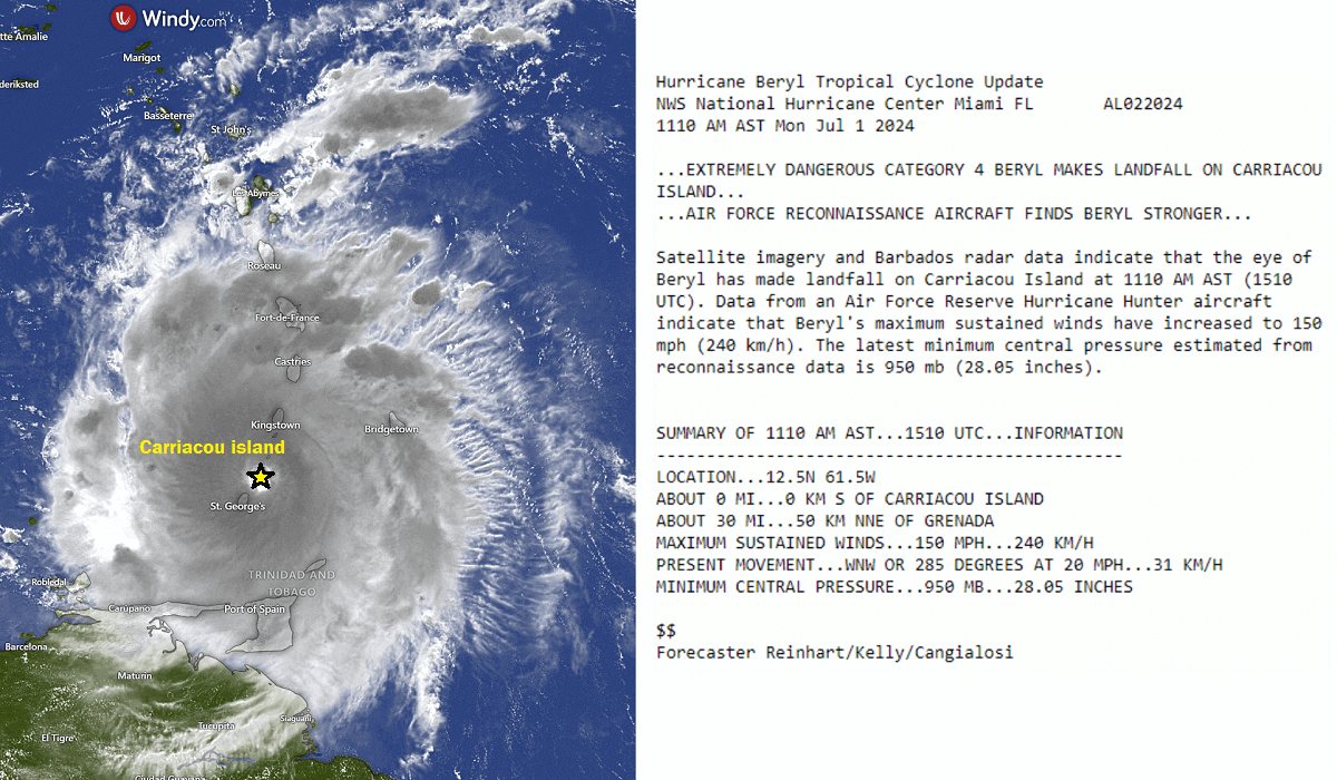
On Monday, Beryl crossed the southern portion of the Windward Islands as an intense Category 4 hurricane with maximum sustained winds of 150 mph. It then crossed the Saint Vincent and the Grenadines island chain and made landfall at Carriacou Island.
One reason Beryl intensified to a Category 5 hurricane more than two weeks earlier than any other Atlantic Category 5 storm on record is exceptionally high Ocean Heat Content Levels (OHCL). The chart for the Caribbean Ocean heat content below indicates what usually occurs in the middle of September, not early July.
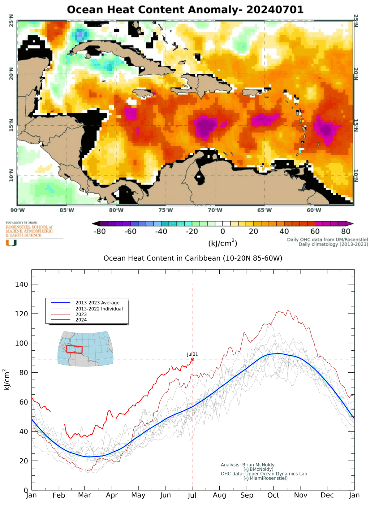
Record-high water temperatures are undoubtedly the primary catalyst of Beryl’s explosive intensification. This clearly indicates how hot the ocean waters in the tropical region have been recently.
The 2024 Atlantic hurricane season officially started on June 1st. After mid-August, the activity typically increases toward the peak in September and October.
Hurricane Beryl: The impressive behemoth and record-breaking Category 5 storm
After explosively strengthening on Sunday, hurricane Beryl tracked towards the Windward Islands early Monday. Beryl’s eye made landfall on Carriacou Island at 1110 AM AST on Monday. At that time, it was Category 4 intensity with 150 mph winds.
Beryl then continued moving west-northwest into the Caribbean Sea and soon intensified into a Category 5 hurricane. On Tuesday, the behemoth storm remained an impressive Category 5 hurricane.
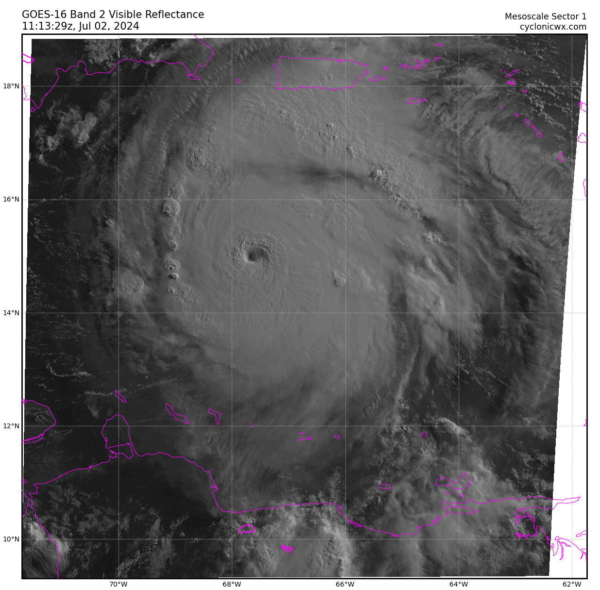
Satellite imagery shows a well-defined eye, expanding outflow, and a prominent outer band.
The NOAA Hurricane Hunter aircraft data showed the minimum central pressure falling near 930 mbar, and the Tail Doppler Radar measured 160-170 kt of wind a few 100s meters above the surface.
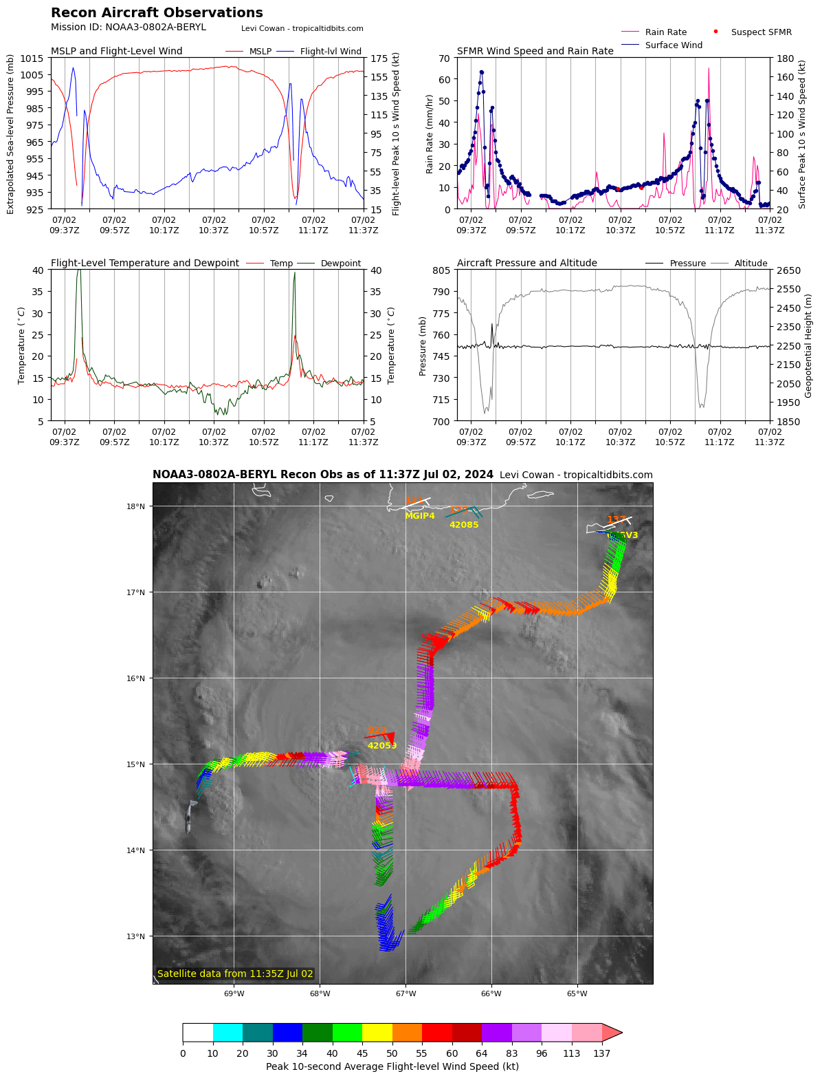
These data support hurricane Beryl’s initial intensity of 160-180 mph, revealing that it increased in intensity overnight into a solid Category 5 storm.
Hurricane Beryl forecast track: Jamaica is next, then the storm heads for Yucatan
Early Tuesday morning light revealed an impressive stadium effect on the satellite’s visible spectrum. This was right when NOAA Hurricane Hunters penetrated the storm and found the winds even more intense than during all recon passes earlier.
Hurricane Beryl is forecast to remain a powerful hurricane as it moves across the Caribbean Sea later this week. A Hurricane Warning is in effect for Jamaica, where hurricane conditions are expected on Wednesday.
A Tropical Storm Warning is also in effect for the south coast of Hispaniola, and a Hurricane Watch is now in effect for all Cayman Islands.
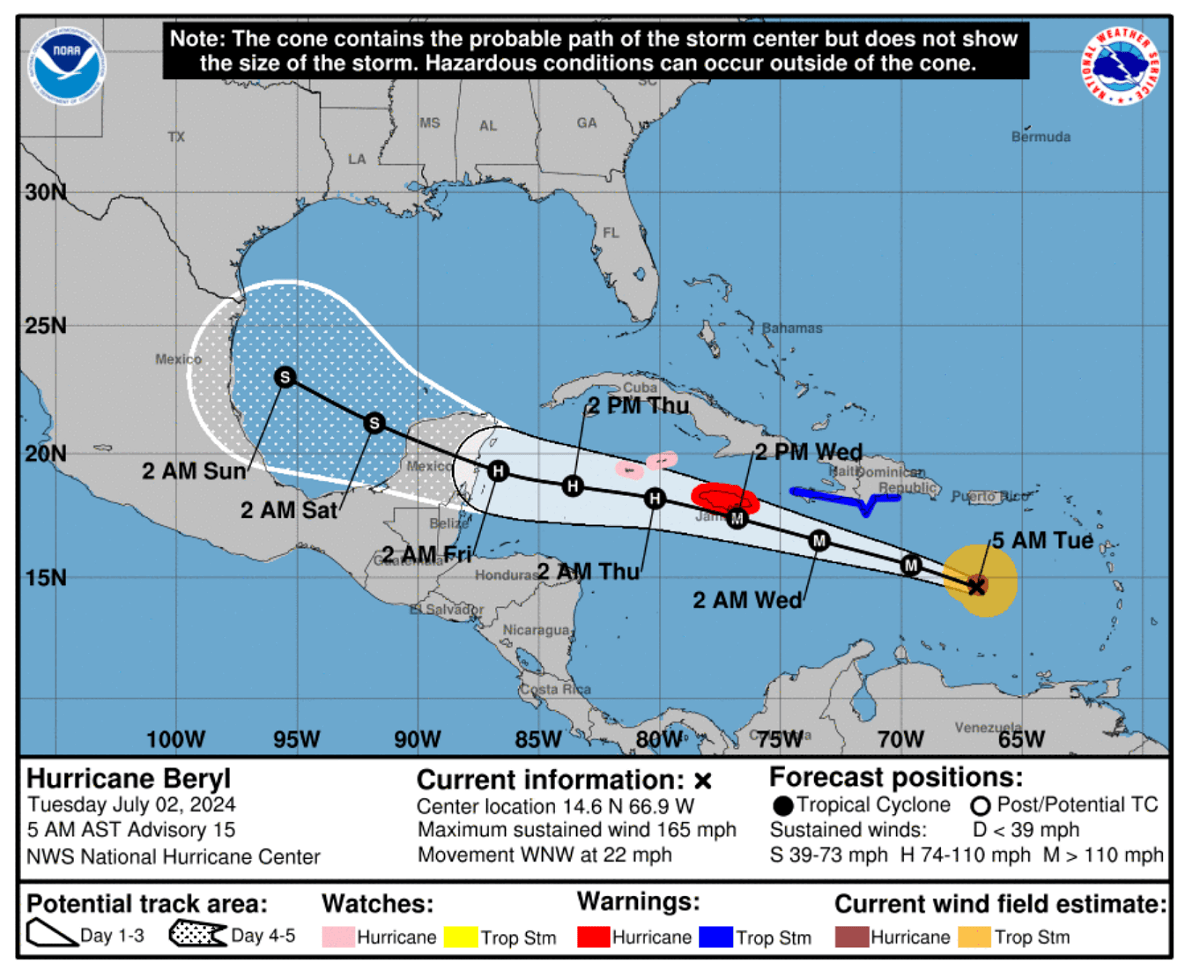
Heavy rainfall and flash flooding will likely occur over much of Jamaica on Wednesday.
Interests in Belize, the Yucatan Peninsula, Cuba, and the southwestern Gulf of Mexico should monitor Beryl’s progress. Additional watches and warnings will likely be required later today or Wednesday.

The uncertainties regarding the future track after the impact with Jamaica remain. The general weather model consensus estimates the next landfall could follow on the Yucatan Peninsula, Mexico.
However, the fresh model data suggests that the peninsula’s miss is still not ruled out.

If this potential track occurs, it would mean Beryl’s intensity would remain much stronger when it enters the Gulf of Mexico. Therefore, the potential impact on the US Gulf Coast would become of the utmost interest after the next weekend.
Atlantic Hurricane Season 2024 Forecast
During an average tropical year, the Atlantic hurricane season produces up to 14 named tropical storms. On average, seven typically become hurricanes, with around 3 reaching the major strength (hurricane of a Category 3 or greater).

A typical Atlantic hurricane season has two peaks. The first period of increased activity occurs from early through mid-September, while the second boost typically happens through mid-October. Statistically, the general increase in activity across the tropical Atlantic typically begins in the trough early/mid-August.
The seasonal forecasts from the Colorado State University (CSU), led by Dr. Phil Klotzbach, hint at 23 named tropical systems, with eleven hurricanes and five major storms forecast for hurricane season 2024. That’s well above the 30-year average. Based on the long-term average, a hurricane season typically brings 14 named storms, seven hurricanes where three reach a major intensity (Category 3 or greater).

The Accumulated cyclone energy (ACE) is also forecast to be much higher than average. This metric compares tropical cyclones’ overall activity, typically 123 for the whole season. For 2024, the CSU forecast calls it above 200.
Major Hurricane Beryl has already made nearly 20 ACE in the last couple of days. And much more has yet to be added this week.

Judging by these pre-peak outlooks, the Atlantic hurricane season 2024 will likely be much stronger than in recent years. To keep things on track, the 2023 hurricane season produced 21 total systems, 20 of which were storms, seven hurricanes, and three major hurricanes.
In 2023, the above-average Atlantic seawater temperatures have led to a busy hurricane season despite the effects of El Nino. These warmer-than-normal sea temperatures are also observed across the Caribbean and the Gulf of Mexico this year, while La Nina will gradually form late in 2024.
This indicates that hotter-than-ever ocean waters will fuel upcoming tropical cyclone formation as hurricane season activity ramps up.

A tropical storm or hurricane organizes and gains its strength when specific weather conditions are met. Typically, hurricanes need a low-shear environment with hot sea waters, which results in plenty of very moist air mass above the sea.
Thanks to overheating oceans, the Atlantic Hurricane Season 2024 is forecast to be much more active than usual, with more storms and tropical cyclones strengthening faster and becoming more intense.
CyclonicWX, Climate Reanalyzer, NOAA, NHC, Colorado State University, and Tropical Tidbits provided images used in this article.
See also: