The collapse of the long-lasting heat dome and an extensive, historic warm period over a large part of Europe has finally happened; the autumn season is here. A more dynamic weather pattern has been established and is yet to become extreme. A combination of subtropical airmass advection, a very warm Mediterranean Sea, and favorable frontal systems will bring significant rainfall to the Alpine region through mid-September.
The first front will cross the northern Mediterranean and the Alps on Sunday night into Monday. As high wind shear and strong instability overlap, there is potential for an outbreak of severe thunderstorms. By early Monday, flooding risk will increase from northern Italy across Slovenia and Austria.

Later next week, a large upper trough will develop over Europe and dig far south across the continent. It will bring the first significant blast of a much colder air mass into central Europe and the Mediterranean, inducing severe weather, additional flooding events, and likely a good amount of snow for the higher Alps.
The first weather front that followed the collapsed blocking ridge flipped the pattern mid-this week. The following satellite image from Friday shows its remnants over the Balkan peninsula. To the west, a large upper low is centered over the Bay of Biscay, gradually moving east. Ahead of it, a new wave of warmth is advecting across the Mediterranean towards the Alps.
Another interesting feature of the satellite is the extremely rare event ongoing in Africa. Due to the more northerly shift of the Inter-Tropical Convergence Zone (ITCZ) than usual, tropical waves that normally move west over the Atlantic are being pushed into the western Sahara desert. The wave is located over Mali and Mauritania.
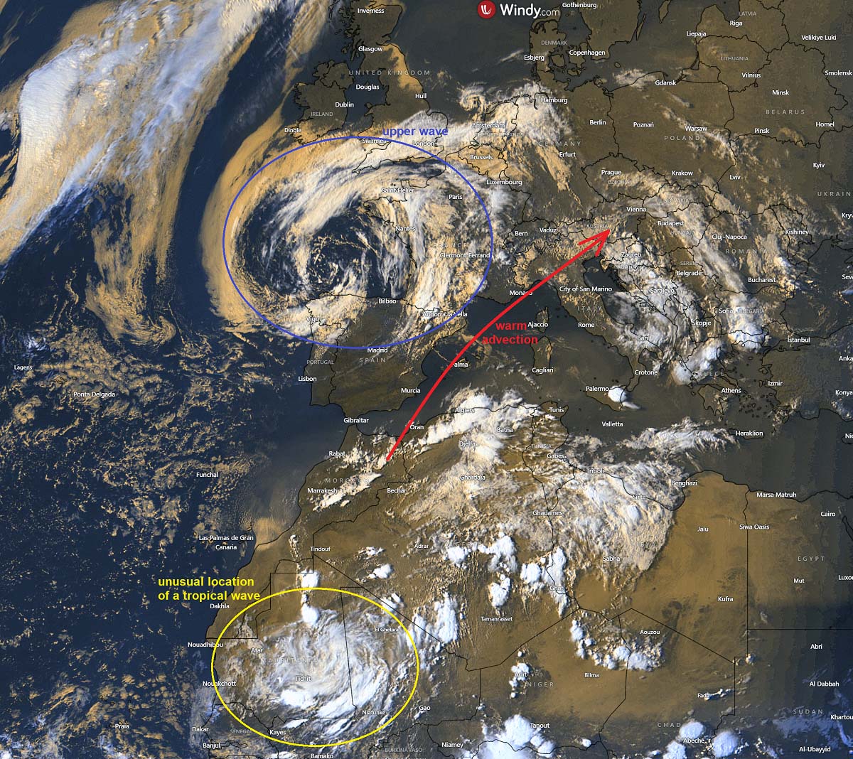
This unique rainfall event is unfolding across the Sahara desert, one of the driest places on Earth. The rainfall is so anomalous that in September, much of the western Sahara will receive over 500% of normal monthly rainfall. Parts of the desert will turn green after this event.
We discussed the following article: Unexpected Rainfall in the Sahara Desert: A Climate Mystery Unfolds.
Both waves, the upper low over western Europe and this tropical wave in northwestern Africa, will help the air mass trajectory bring warm and significantly moist air into the northern Mediterranean and central Europe in the coming days. This will lead to severe weather and potential flooding events.
In addition, the extreme marine heatwave, combined with the still unusually warm Mediterranean sea waters, will contribute more moisture to the upcoming rainfall periods through mid-September.
Let’s now dig into the details of the developing weather pattern, as it is much more dramatic than Europe’s patterns in the late summer period.
Extreme Mediterranean marine heatwave in place as unusually warm waters remain
After the extensive and long-lasting heatwaves this past summer, the global seas, the seas around Europe, and especially the Mediterranean Sea have warmed significantly. A so-called marine heatwave is a new norm in recent years, as the seas have become extremely warm worldwide.
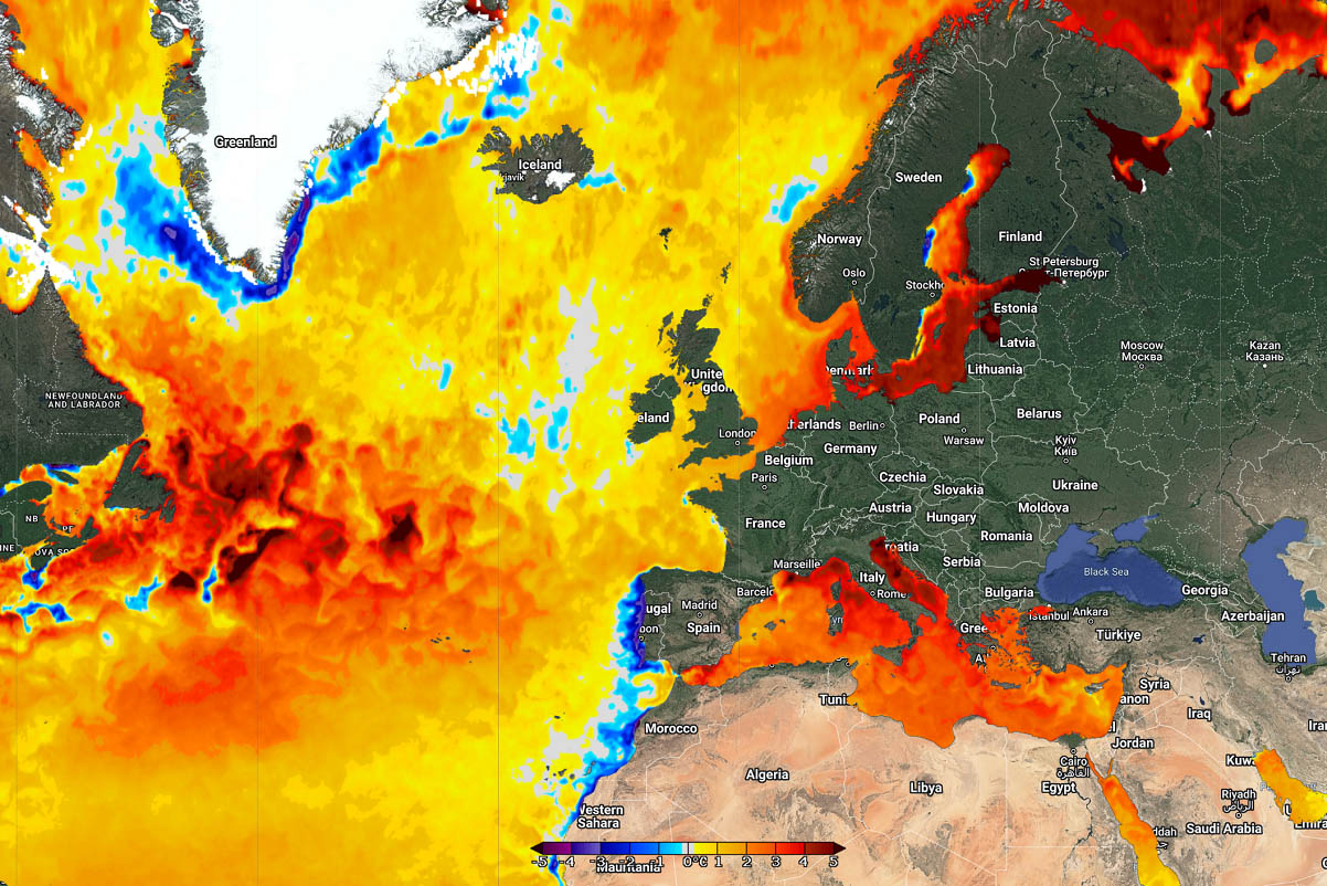
Sea waters are still extremely warm around Europe this early September, as seen in the image above. The most significantly warmer and anomalous temperatures are over the Baltic, North, and Mediterranean regions.
Those include the Liguria and Tyrrhenian Seas, the Adriatic Sea, the Ionian Sea, and the Aegean Seas. These water temperatures are about 4-6 °C warmer than average, which is extreme.
The following close-up satellite analysis of the Mediterranean Sea region represents water temperatures in late August. Notice that the southern Mediterranean, Tyrrhenian, northern Adriatic Sea, and Eastern Mediterranean still had water temperatures between 28 and 30 °C.
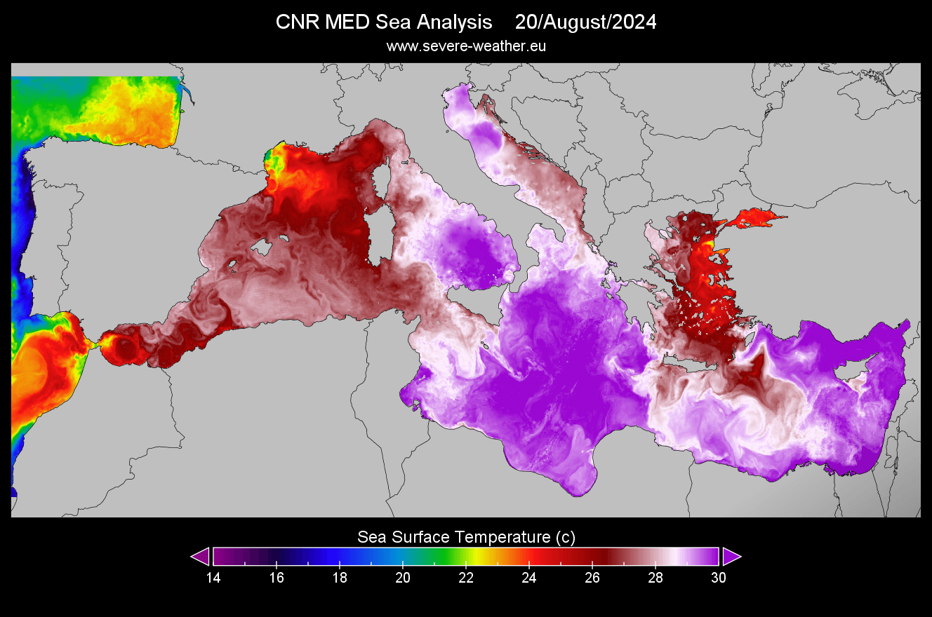
This was maintained due to the extended period of intense heatwave that lasted for a couple of weeks from early August to the early days of September.
Closely monitoring the extremely warm Mediterranean Sea in late summer and early autumn is needed, as warm seas play an important role in rainfall events. The warmer the seas, the more extreme and torrential rainfall can occur. There have been numerous cases where several hundred mm of rainfall led to destructive flooding across coastal Italy, Spain, the Alps, and the western Balkans.
One recent example was the historic and devastating rainfall event in Slovenia on August 4th, 2023, causing billions of dollars in damage.
The following video animation represents the Mediterranean Sea temperature anomaly during summer this year. It shows how it was constantly above the average and became extremely anomalous throughout July and August.
While these anomalies have occurred in previous years, they were particularly severe in 2024 due to a record-breaking summer season in the region.
The upper low moves towards central Europe and becomes negatively tilted by Sunday
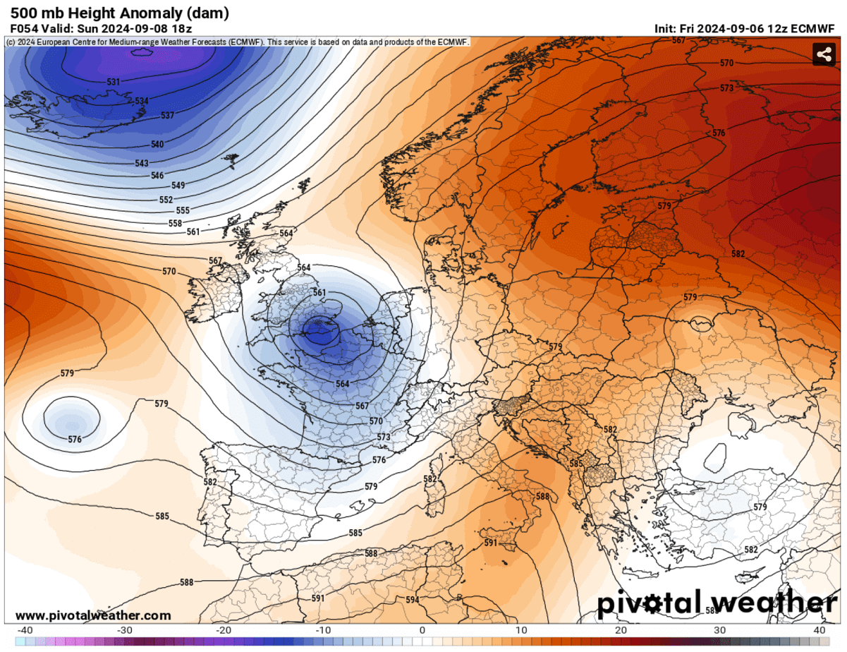
This weekend, the general weather picture across Europe indicates a departing upper ridge over eastern Europe, extending over the Mediterranean. To the west, a large upper low gradually transforms and emerges with a large wave over the Atlantic.
By Sunday, the wave will become negatively tilted while sliding towards central Europe. A surface frontal system will move towards the northern Mediterranean and the Alpine region.
This will induce an unstable air mass over the region as strong warm advection combines with the warm Mediterranean Sea and will overlap with the jet stream winds aloft. Thus, strong wind shear will overspread the unstable air mass. A perfect recipe for severe thunderstorms will be possible, leading to intense rainfall, strong winds, and even tornadoes.
As discussed with the satellite image earlier, the combination of the upper low on the west and the unusual location of the tropical wave in northwestern Africa will result in very high precipitable water (PWAT) content spreading towards the Mediterranean and the Alpine region.
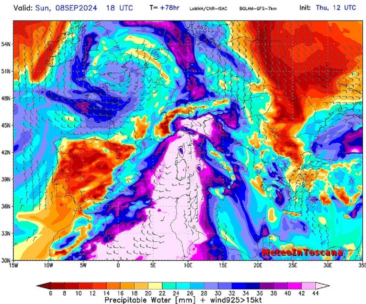
This normally means that rainfall becomes more torrential as more water-content layers are throughout the atmosphere. Combined with a strongly unstable air mass, this usually leads to intense flash floods. The chart above indicates that the PWAT will be off the charts ahead of the front associated with the upper wave on Sunday.
Conditions will deteriorate by mid-Sunday across North Italy, and an unstable airmass will be encountered. Severe thunderstorms will likely spread east overnight Sunday into Monday towards the Adriatic Sea and the Balkan peninsula.
These storms are expected to bring intense rainfall, severe winds, flash floods, and possibly tornadoes along the coasts of Ligurian Bay and northern Adriatic.
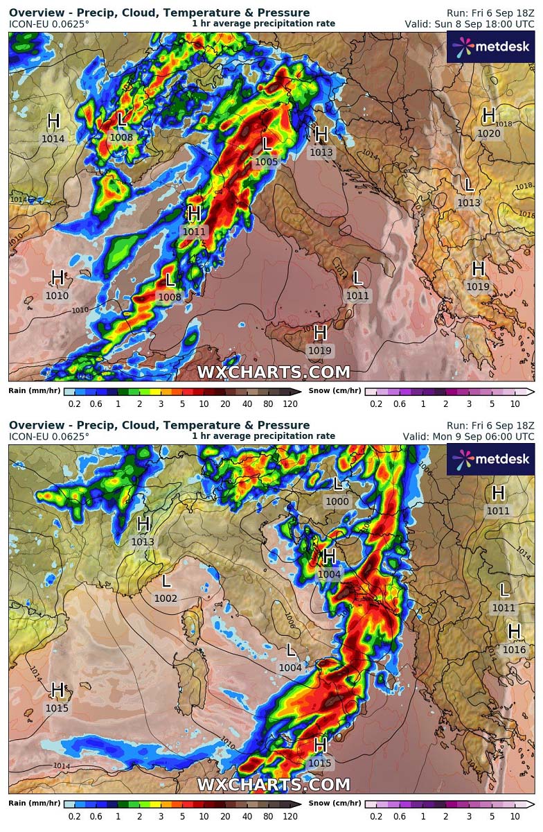
By Monday morning, the cold front will already reach south-central Italy and the south Adriatic Sea, grazing across western Balkan peninsula countries. The Eastern Adriatic coast should be on high alert for intense storms with potentially damaging winds, tornadoes, heavy rainfall, and local flooding.
The accumulated rainfall for this event will vary greatly, depending on the local topography and how effectively the unstable airmass will serve the best conditions, combined with the orographic rainfall due to strong, moist, south-southwesterly winds.

The northern Apennines and the Dynaric mountain range should expect around 150-200 mm or more locally from Sunday through Tuesday in about 48 hours. These areas include coastal areas where intense flash floods are the most likely to develop.
Another deep wave with more excessive rainfall arrives, followed by a significant cold blast into central Europe
Once the first wave is over by early next week, a short break in the activity is foreseen. But the North Atlantic will already be brewing a potential what’s next for the European continent late next week. A strong blocking High will develop over the Atlantic, combined with a deep and powerful upper wave digging south after mid-week.
This will establish a significantly colder air mass corridor from the north towards the deep south over Europe, reaching the Mediterranean by next weekend. The following 500 mbar heights chart represents the situation over Europe next Friday: a blocking High on the west and a deep low over the continent, with its core over the Alps and northern Mediterranean.

Such a weather pattern setup is usually a recipe for an extended period of excessive rainfall and high risk for flooding potential across the region. As the first wave on Sunday and Monday will be fast-moving, there will barely be much effect on the warm seas. So, the marine heatwave with warm waters will remain in place for future frontal waves.
This means the second system could bring even more rainfall to northern Italy, Austria, Slovenia, and Croatia late next week. History tells us these events are of great concern and should be closely monitored for potential flooding.
The following chart indicates the total rainfall over the next 10 days. A lot of rainfall is forecast along the Dynaric mountain range from western Slovenia to Albania and over the Alpine range, with local 200-400 mm well possible.

Remember that this chart above is indeed a global ECMWF weather model, so local anomalies (usually in the worst way) are likely. Thus, even more rainfall could result. Such amounts undoubtedly have the potential for damaging floods.
The Meteogram charts show both frontal systems with excessive rainfall. Below is a comparison of two locations, Bovec (northwest Slovenia) and Mariazell (northeast Austria), over the next 14 days. Notice that the first system on Sunday night is short but very intense.
The second rainfall event that follows late next week will be longer but also bring a lot of additional rainfall.

One can also clearly see that the temperatures will increase just before the first event strikes on Sunday. This represents a strong, warm advection we discussed earlier, leading to an unstable airmass for the first front. Later, the overall temperatures will be much colder with the second system on Friday and the next weekend.
The strong blocking High over the North Atlantic will block the warmer zonal flow, trapping the large trough/low between the Atlantic High and another one on the east. The meridional flow from the north will deliver much colder air mass towards the south, reaching central Europe and the Mediterranean by Friday.

Much colder weather will follow over the next weekend, with temperatures around 8-12 °C below the average for mid-September. They should last several days, as the upper low will be large, and it will take longer to vanish and gradually decay the week after.
Under the strong High on the east, a much warmer air mass will maintain towards Arctic Russia, partly also affecting eastern Scandinavia and Europe. It will be much colder than normal across the western half of Europe.

With this intense blast of chilly refreshment, the cold wave will likely also lead to the first significant snowfall in the Alps, with a good chance for high snow accumulation in higher levels above 2000 m ASL.
The following charts show the accumulated new snow for the next weekend, which exceeds 100 cm in a few days from Switzerland to Austria. High snow will also be possible across the Italian and NW Slovenian Alps (Julian Alps).

Stay alert for worsening weather conditions in the coming days and late next week. Significant flooding events, including severe weather, are likely to occur.
Wxcharts and Pivotalweather provided images for this article.