With strong pressure anomalies around the Northern Hemisphere, we are currently observing an unusually weak Polar Vortex in the Stratosphere above the North Pole. This has implications for future weather development and is also connected to how weather patterns will develop over the United States and Canada this month and potentially even in the Winter of 2024/2025.
We already discussed a weaker Polar Vortex for September. But since then, the Polar Vortex has not really strengthened much and is currently marked the weakest it has been in early October in the past 40 years.
The Polar Vortex normally plays a major role during the Winter season. But this year, it is starting out unusually weak, which can carry important implications for the upcoming Winter season, as it has happened already in the past, during the 1981/1982 Winter season.
POLAR VORTEX DEVELOPMENT
The best way to understand the Polar Vortex is to visualize it. In simple terms, it is just a name that describes the broad winter circulation over the northern (and southern) hemispheres.
Below, you can see a 3-dimensional image of the Polar Vortex. The vertical axis is greatly enhanced for better visual presentation. It shows the actual structure of the Polar Vortex and how it is connected down to the lower levels and the pressure systems.

The Polar Vortex extends over many layers of the atmosphere. The lowest layer is called the troposphere, where all weather events occur. But above that, we have the stratosphere, a deeper and drier level that is also home to the ozone layer.
For this reason, we always separate the entire Polar Vortex into an upper (stratospheric) and a lower (tropospheric) part. They both play their role differently, so we monitor them separately. But both parts together form the weather circulation across the Northern Hemisphere.

To put the Polar Vortex into perspective, we produced a high-resolution video below. This video shows the vortex in 3D, giving you a better idea of what it actually looks like. However, note that the vertical size of the vortex was greatly enhanced for visual purposes.
The main takeaway from the video should be that the Polar Vortex is not just one winter storm or a cold outbreak that moves from the Midwest into the eastern United States. It is the entire weather circulation over the Northern Hemisphere.
CURRENT STATE OF THE POLAR VORTEX
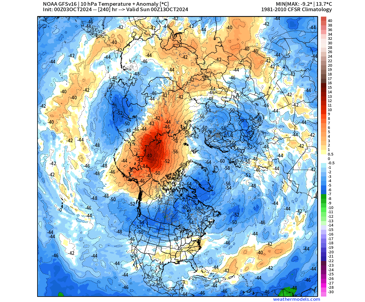
The Polar Vortex is currently smaller in size, but it is displaced a bit towards Siberia. The image below shows geopotential height and temperature in the mid-stratosphere at the 10mb level (30km/18.5miles). The Polar Vortex looks like a “cyclone” with a cold core near its low-pressure center. Image by weatheriscool.com
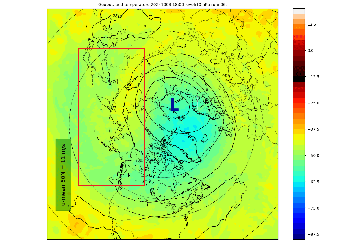
You can see a weak warm area on its Pacific side. That is also where an anomaly of high pressure is developing in the Stratosphere, helping to push the Polar Vortex off center and limiting its strengthening.
Below is the image for the same level, but it shows the pressure anomaly. It nicely reveals the pressure anomaly in the stratosphere over the western parts of the Polar Vortex.

Let’s look at the 3D structure of the whole Polar Vortex. We can see it is currently not fully extended to the lower levels, which is not that unusual as October is the month when the Polar Vortex is expected to strengthen and connect downwards.
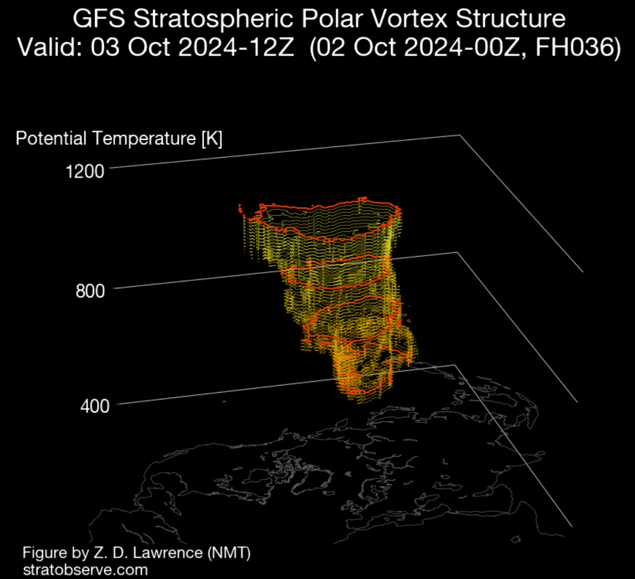
But you cannot really “disconnect” the air itself, so we can still track the pressure anomalies. The vertical pressure anomaly structure can directly reveal the connection between the stratospheric Polar Vortex and the lower levels.
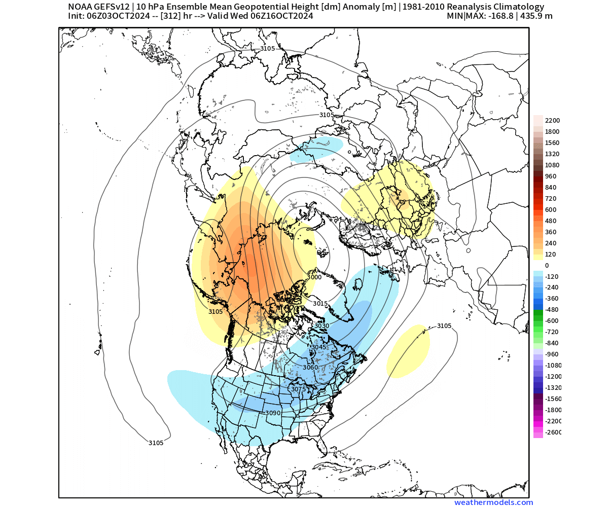
Below is the vertical pressure analysis from the ground up to the top of the stratosphere (45km/28 miles). You can see the strong negative anomalies over Greenland and the polar regions in the stratosphere, connected all the way to the surface levels under an angle into Siberia.
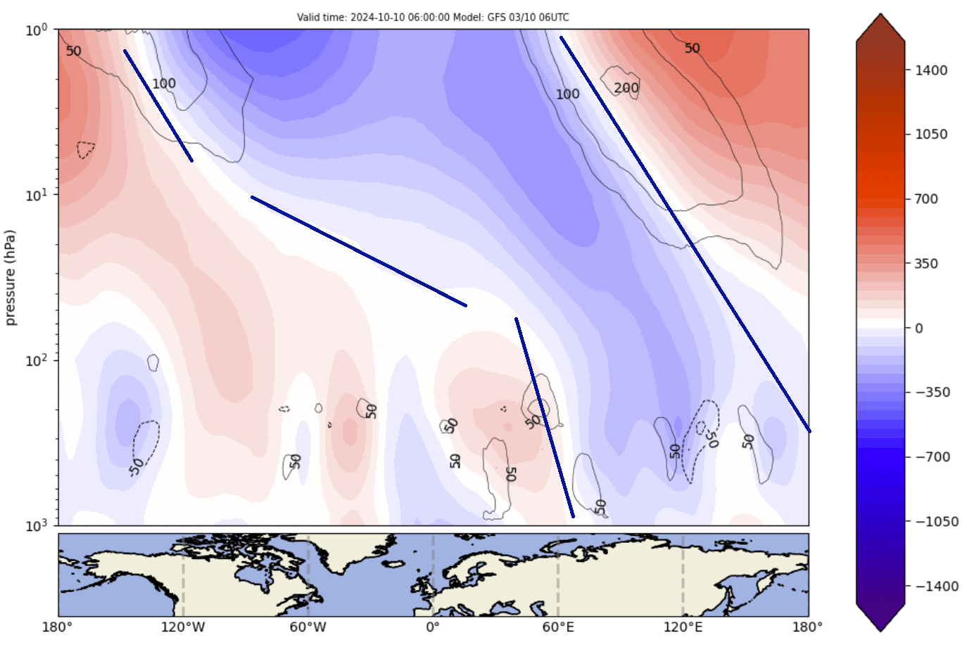
You can also see the high-pressure anomaly surrounding the Polar Vortex over the entire stratospheric level over the Pacific side. This is what is pressing against the Polar Vortex, also affecting its structure and limiting its development.
This can be seen reflected in the weather pattern analysis below. You can see the pressure anomalies across the Northern Hemisphere in the next 5 days. You can see the concentrated low-pressure area over the lower polar regions, which is acting like the “foot” of the stratospheric Polar Vortex that you can see in the image above.
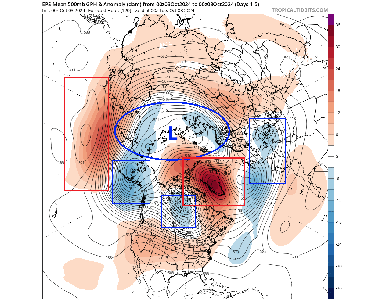
A strong high-pressure anomaly is developing over Greenland. It is going to push deep into the polar regions, almost breaking apart the lower Polar Vortex into individual areas. You can also see the strong pair of high and low-pressure areas in the North Pacific and Aleutians, driving the energy up into the stratosphere.
This affects the temperatures around the northern hemisphere. With a weaker low-pressure area over the pole, the colder air is transported out. But since we are just in early October, there is not really any strong mass of cold air available for significant anomalies.
The reason we showed you this is to reveal the connection and importance of the stratospheric Polar Vortex and its link with the weather at the surface. A situation like this in December or January would have a much different outcome, with more proper winter weather over the eastern United States.
We must monitor the state of the Polar Vortex, because it can have a profound impact on our daily weather. We mainly separate the Polar Vortex into two different modes:
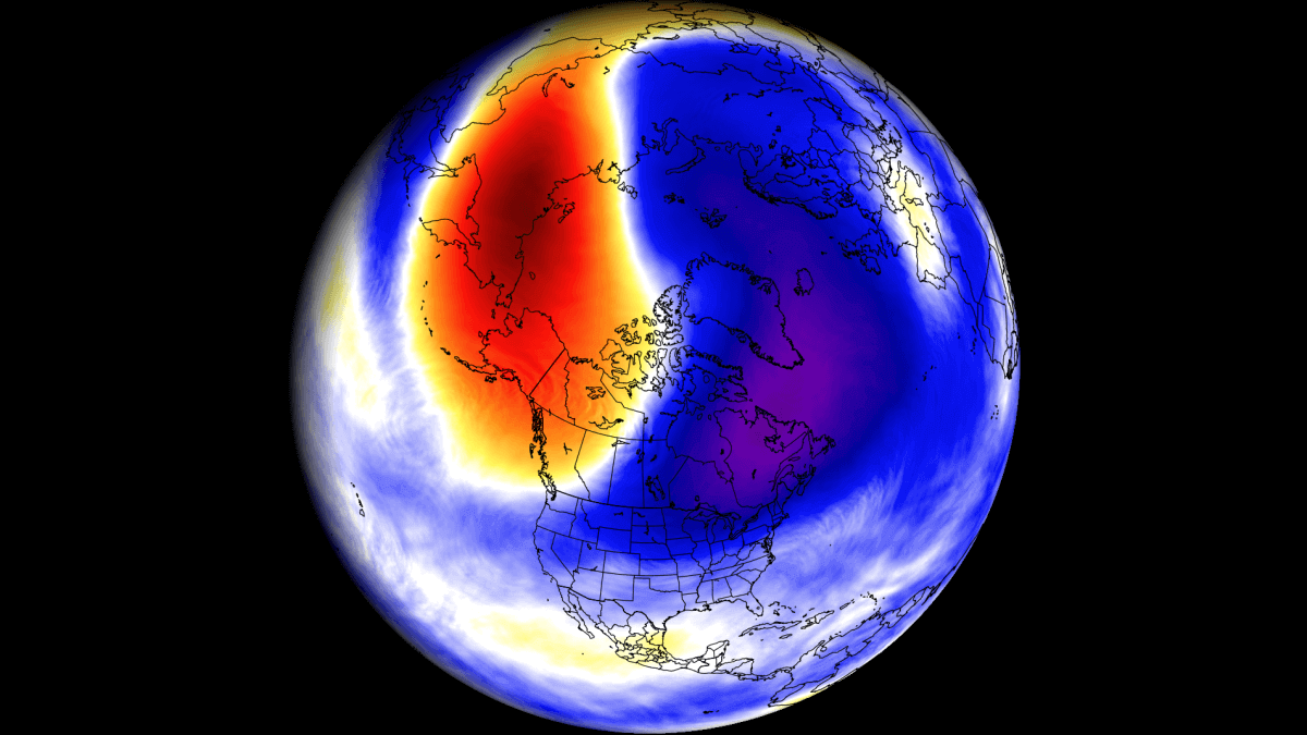
A strong/stable Polar Vortex usually means strong polar circulation and jet stream. This contains the colder air into the Arctic Circle, creating milder conditions for most of the United States.
In contrast, a weak/disrupted Polar Vortex creates a weak jet stream pattern. As a result, it has a harder time containing the cold air, which can now escape from the polar regions into the United States. Image by NOAA.
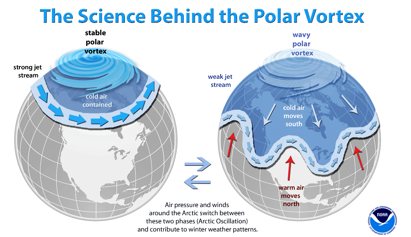
So, if you want cold and snow during Winter, and you live in the central or eastern United States, your odds are highest with a weak Polar Vortex. In nature, that means a heavy disruption of the jet stream and a release of cold air from the polar regions.
For this reason, we closely monitor the strength of the Polar Vortex and all the changes around it. This is even more important when there are sudden changes in the strength of the Polar Vortex, with potential warming events.
CHANGES IN THE ATMOSPHERE
But how do we measure the strength of the stratospheric Polar Vortex? The simple answer is the wind. The more organized the stratospheric polar Vortex is, the stronger the winds inside and around it, which means it can have a stronger influence on the surface.
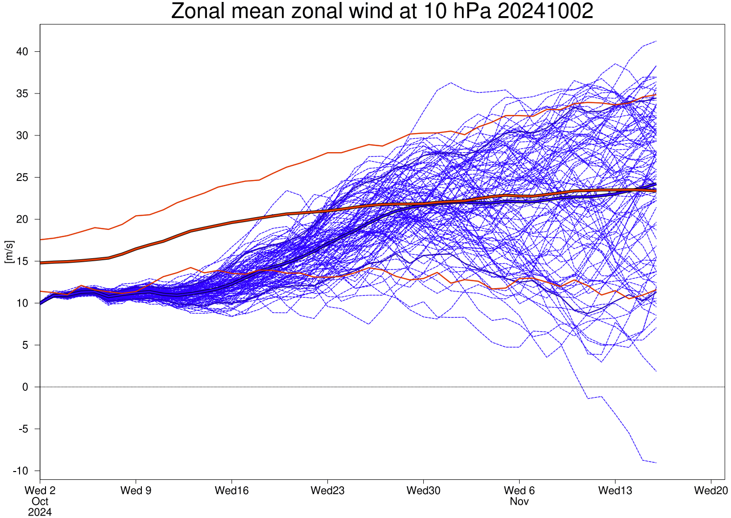
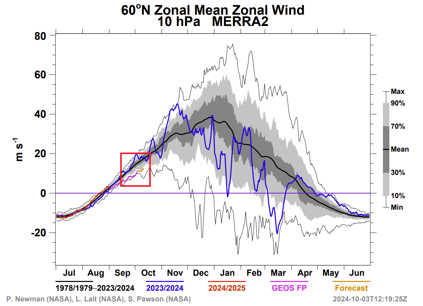
The image below shows the wind analysis and forecast for the next 30 days in the mid-stratosphere. Black lines are the ensemble forecasts, and in the background, we have the climatology, showing the normal values and the highest and lowest recorded data.

You can see that currently, and for the next two weeks at least, the stratospheric Polar Vortex will be running much weaker than normal. In the coming days, it will approach the record weak point for this time of year for the past 66 years.
This signals that something is off both in the lower and especially in the higher parts of the atmosphere. These effects can usually transfer down to the lower levels, with some delay, altering the weather patterns.
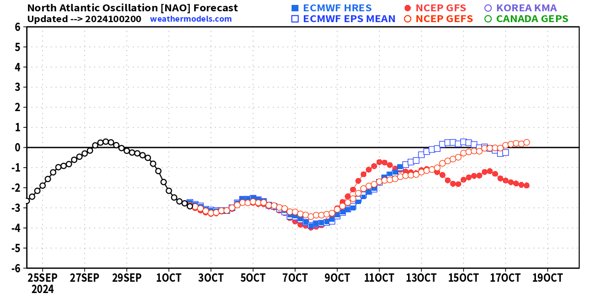
Another model we often look at is the ECMWF, which also has an extended forecast for the stratospheric winds. The image below shows an unusually weak Polar Vortex for much of October, running in the very lowest values for this time of year. The thick red line is the normal wind for this time of year.
But all these low values are not just on a graph, but can also be seen in the actual weather and the developing patterns.
WEATHER CONNECTIONS
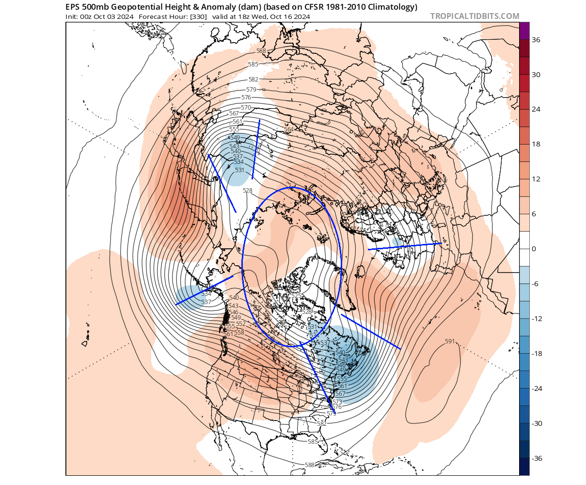
If we look at the Polar Vortex forecast on day 10, we can see a strong high-pressure anomaly in the stratosphere still at the western side of the Polar Vortex. But as the vortex still grows in October, it starts to expand.

Because the Polar Vortex is growing but is blocked to the west, it starts to create an extension into North America. You can see that, as an arm of the Polar Vortex is extending into North America.
Looking at the stratospheric temperature forecast for the same period, you can see a large temperature anomaly over the same area as the pressure anomaly. This is not like a true stratospheric warming event, not this early in the season. But it clearly indicates that the Polar Vortex is in a very disrupted state.
The main question at this point is how this reflects in the lower levels and our weather patterns?
We can try to track the changes in the lower atmosphere by using a special polar circulation index. This index is related to the lower Polar Vortex and its strength. The higher the index goes, the stronger the Polar Vortex and the stronger the weather circulation, and the opposite with negative/low values.
This index is shown in the forecast image below. It will run negative for at least half the month, which means weak circulation and a disrupted Polar Vortex. This has implications for weather patterns across the Northern Hemisphere.
If you saw such a negative index for the December-February period, this would mean an almost certain snowfall and cold air outbreak across the eastern United States. Since we are in October, the pattern still gets disrupted, but we can’t really expect snow and cold. Yet.
First, we can look at the lower pressure pattern for late next week. The forecast clearly shows the very weak and disrupted circulation. A high-pressure anomaly took over the polar regions and also the western United States.
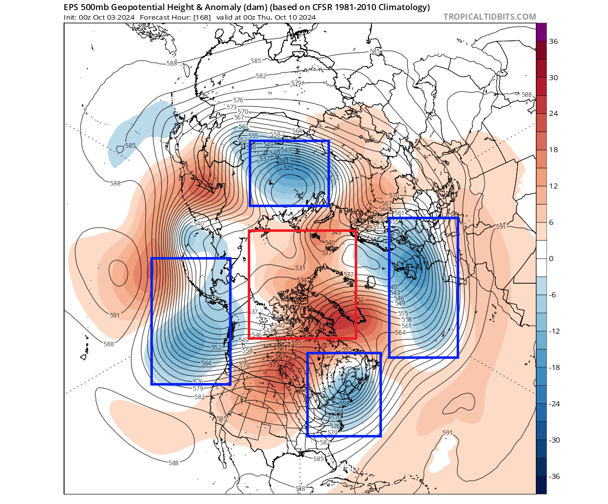
The normal circulation is disrupted, so instead of a large low-pressure area over the pole, we have several smaller ones. This creates very different weather patterns across the Northern Hemisphere compared to an organized and strong Polar Vortex.
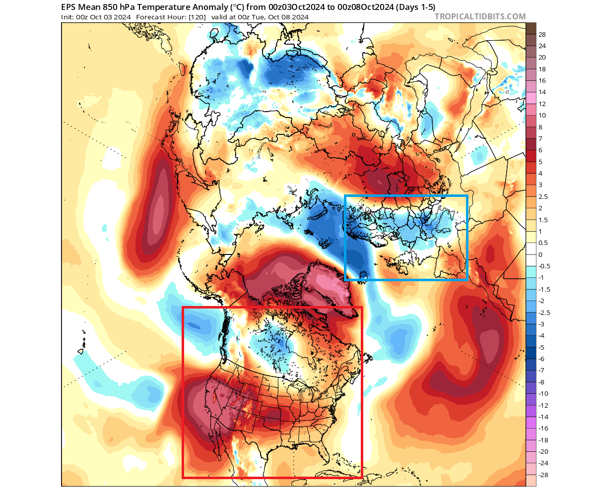
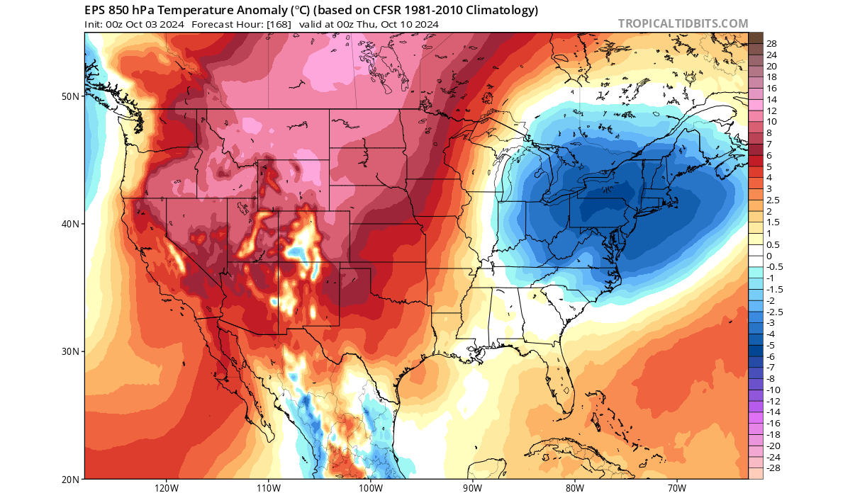
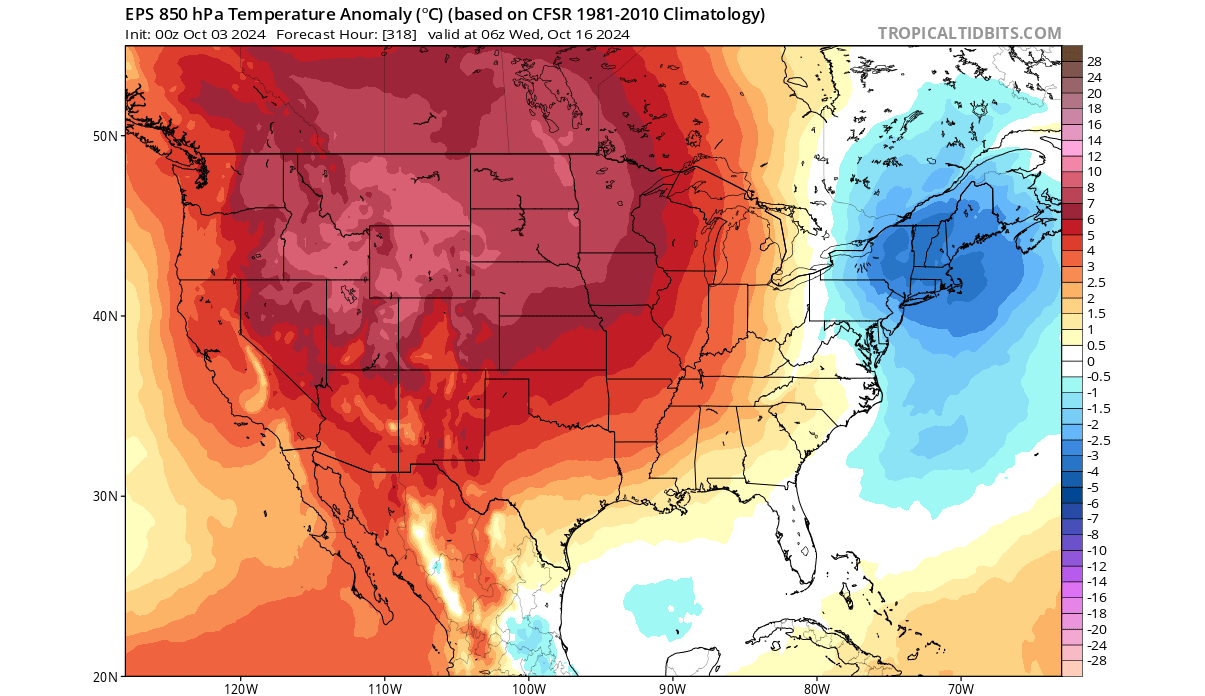
Looking at the temperature pattern for the same period, you can see an important cold anomaly over the eastern United States. That is the leftover of a displaced “arm” of the Polar Vortex and the extensions in the stratosphere that we showed earlier above. There are three more across the Northern Hemisphere as the Polar Vortex is disrupted.

Looking closer at the United States and Canada, you can see quite a broad area of lower-than-normal temperatures over the east. In early October, this won’t bring freezing temperatures or snow to the eastern and northeastern United States.
But the reason we are looking at this pattern is that if this were to repeat in 2 months, then the actual weather outcome would be a more proper cold and also a snow cover over the east and northeast. So, these current events tell an important story of how important the Polar Vortex is at any point in time, especially if you want proper winter weather.
But there are indications that a weaker Polar Vortex in Autumn/Fall can be more prone to stay weak or even fully collapse when it comes into winter.
THE DISRUPTION CONTINUES
As we have seen, the stratospheric anomalies are expected to last into the second half of the month. Below is the 3-dimensional structure forecast, and you can nicely see the very compressed and elongated structure of the Polar Vortex. We have marked the blue circle in the surface area to outline where the surface connection is.
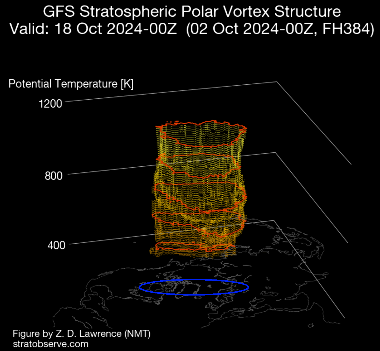
This elongated shape is also seen in the stratospheric forecast for mid-month. The high-pressure anomaly still exists over the western side of the Polar Vortex, reaching into Siberia. Of course, due to this anomaly changing the shape of the vortex, it is still extending its southern end into North America.
Below is the lower-level pressure pattern forecast for the same period. You can see this elongation reflecting down. The main low-pressure arm is also in the same area, extending into the northeastern United States and eastern Canada. This just shows how important it is to follow the development at all levels of the Polar Vortex any day of the cold weather season.
Other low-pressure arms are not as strong in this forecast, so we will look at the temperature anomaly under the main low-pressure area.
The temperature anomaly forecast for the same period shows an interesting pattern for the United States and Canada. You can see another cold anomaly over the northeastern United States and southeastern Canada. Again, in mid-October, this won’t bring snow to the Northeast of the United States.
This again shows just how much potential these weak Polar Vortex events have to bring anomalous weather and, in many cases, a proper winter week or two over the eastern United States and Canada.
But can we use these current events as any indication for the upcoming Winter of 2024/2025?
INTO WINTER 2024/2025
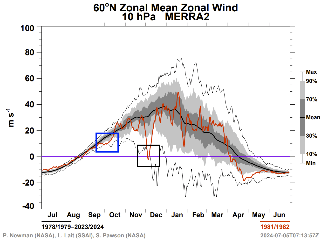
Usually, such unusual early development must also influence long-range weather development. In some cases, these anomalies do not mean much. But we can actually find another similar event in early October, dating back to the 1981/1982 season.
Below is NASA’s stratospheric wind analysis/forecast for the current 2024/2025 season. Ignore the blue line, which shows the last season. You can see that we are drifting at very record-low values for this time of year, as also shown earlier in the article. But when was that record low point created?
The answer is in October 1981. Below is the same NASA analysis for that season. You can see the same pattern in October, with half the month running at record-low values. The Polar Vortex did spin up to normal values but never was really strong. In early December, the stratospheric winds got reversed from a Sudden Stratospheric Warming event, which set the tone for the rest of Winter.
Below is the pressure anomaly pattern for the Winter of 1981/1982. You can see a high-pressure anomaly over the polar regions, just like we see now in our current pattern. But as this was in the December-January-February period, the energy was much higher, the air was colder, and the pressure systems were stronger.
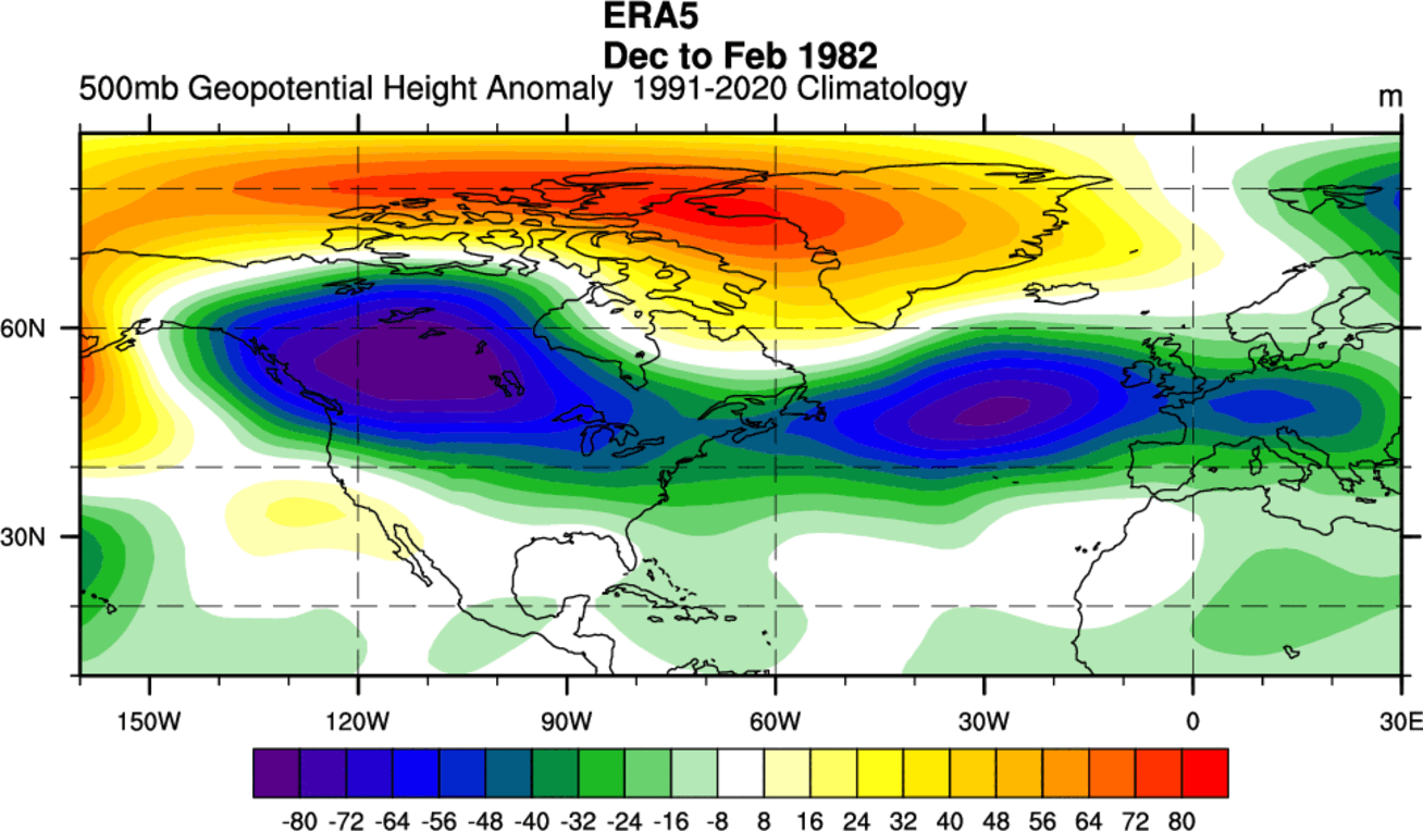
The low-pressure areas were strong and covered Canada and the United States and extended all the way over the Atlantic.
Looking at the surface temperature analysis for the same period, we can see the expected image: cold air anomalies over much of Canada, expanding into the northern and eastern United States.

This is probably one of the more typical good winter scenarios for the eastern United States, and it was largely aided by the Polar Vortex and its dynamics.
Of course, nobody can guarantee or even say that we will now have the same pattern in the upcoming Winter 2024/2025. But we are looking at how past anomalies and unusual developments have continued into the following Winter, reminding us how small changes can have a long-reaching impact.
We will keep you updated on the global weather pattern development, so bookmark our page. Also, if you have seen this article in the Google App (Discover) feed, click the like button (♥) there to see more of our forecasts and our latest articles on weather and nature in general.
January weather pattern change: