A unique rainfall event is currently unfolding across the Sahara desert, one of the driest places on Earth. The amount of rainfall might not seem large by normal standards, but a large part of the Sahara will get well over 500% of normal monthly rainfall in September.
It’s not very often that the Sahara desert experiences these rainfall events. They are very rare, less than once per decade on average, but they are usually a sign that something is changing in the Earth’s weather system, indicating an unusual state of the Atmosphere as we head into Autumn and Winter.
This article was updated on “September 2nd” with the latest forecast graphics and an additional segment on the potential reason for such an unusual event.

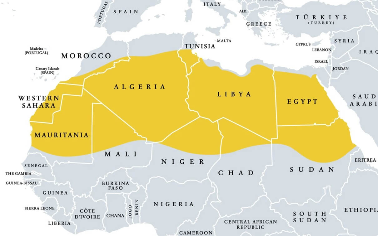
THE DRIEST PLACE ON EARTH
Sahara is called one of the driest places on Earth because it receives little to no yearly precipitation. It is one of the world’s largest and hottest deserts, extending from the Atlantic Ocean in the west to the Red Sea in the east. It covers over 9.2 million square kilometers (3.6 million square miles).
This region is hot and dry because it is under the subtropical ridge, a permanent high-pressure system. This ridge causes the air to descend, making the atmosphere dry and stable and preventing cloud formation and precipitation.
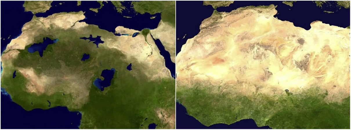
But the Sahara was not always a hot wasteland. Just a few thousand years ago (6000-11000), it was a green region with lakes, rivers, and lush vegetation. But changes in the Earth’s orbit caused shifts in the world’s weather patterns. That abruptly transformed the green region into some of the driest land on Earth.
Below is an image that compares what scientists believe northern Africa looked like a few thousand years ago. It was a green area filled with life, but weather changes have transformed it into the dry, hot region that we know today.
WEATHER AND PRECIPITATION
The image below shows the average monthly rainfall for August in the past 53 years. You can see that the Saharan region is mostly void of precipitation, with only some low amounts in the more southern regions. But notice the very strong belt of precipitation across the Equator.
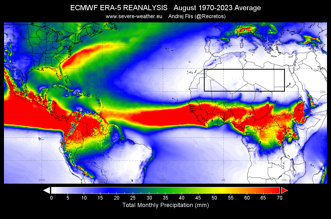
That tropical rainfall belt is called the Inter-Tropical Convergence Zone (ITCZ). It’s basically a band of clouds, showers, storms, and rainfall that is spread around the whole Equator. This feature exists because the trade winds from both hemispheres meet, creating rising motion, clouds, and rain.
In the image below, you can see the latest ITCZ analysis by NOAA. The black line shows the normal (expected) position of the ITCZ for this time of year. But the red line shows the actual position of this anomaly, and you can see it has shifted much to the north.

The graph data shows an even better picture of the ITCZ position over Africa. We can see that since June, the ITCZ has been shifting much more to the north than usual. This can drastically change the weather patterns over the region and also affect the Atlantic Hurricane Season.

Because the whole ITCZ has shifted to the north, strong thunderstorm systems move into the Atlantic Ocean at a higher latitude over colder waters. That means we can get fewer tropical systems powering up as they move out of Africa at a bad location to organize and intensify.
This is just one of the indirect impacts that the ITCZ position in Africa can have on the weather in North America, especially during the Hurricane Season in the United States.
But the more immediate affect of this northerly shift is that it brings rare rainfall events deep into the Sahara desert.
RAINFALL IN THE DESERT BEGINS (UPDATED)
Over half of the Sahara desert receives less than 25mm (1 inch) of yearly rainfall. Occasionally, more rainfall is found along the southern portions as the ITCZ shifts up and down. But a full on rainfall event across most of the desert is not something we see every year, or perhaps even every decade.
Below is the latest GFS model forecast for total rainfall in the next 16 days. What you see is rainfall covering a large part of the Saharan desert. The amounts might not look high, but if we consider the total yearly amount, many regions have a few years worth of rain in a few days. Image by weathermodels.com using a commercial license.
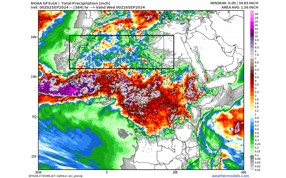
Some areas of the Desert are forecast to see over 1 inch (25mm) of rainfall, which is 5-10 years’ worth of precipitation, making this truly remarkable event.
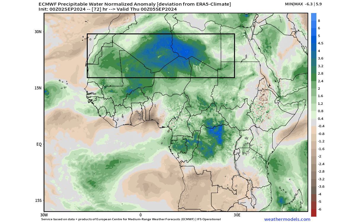
The image below shows the forecast of total atmospheric water compared to normal values. As you can see over the Sahara, the values are on the magnitude of 5-8x over the normal values, making this event in the range of roughly once in several thousand years.
Below is a video animation that shows the accumulated precipitation over Northern Africa. It nicely shows the progress and the spread of rainfall across a large part of the Saharan desert.
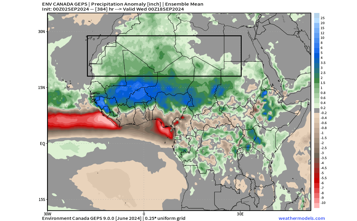
Precipitation anomalies also give us a very clear picture. An anomaly is a deviation from the normal. So the ensemble rainfall anomaly forecast below shows that a large part of the Saharan desert will experience a widespread rainfall anomaly in the coming two weeks, and likely deeper into September.
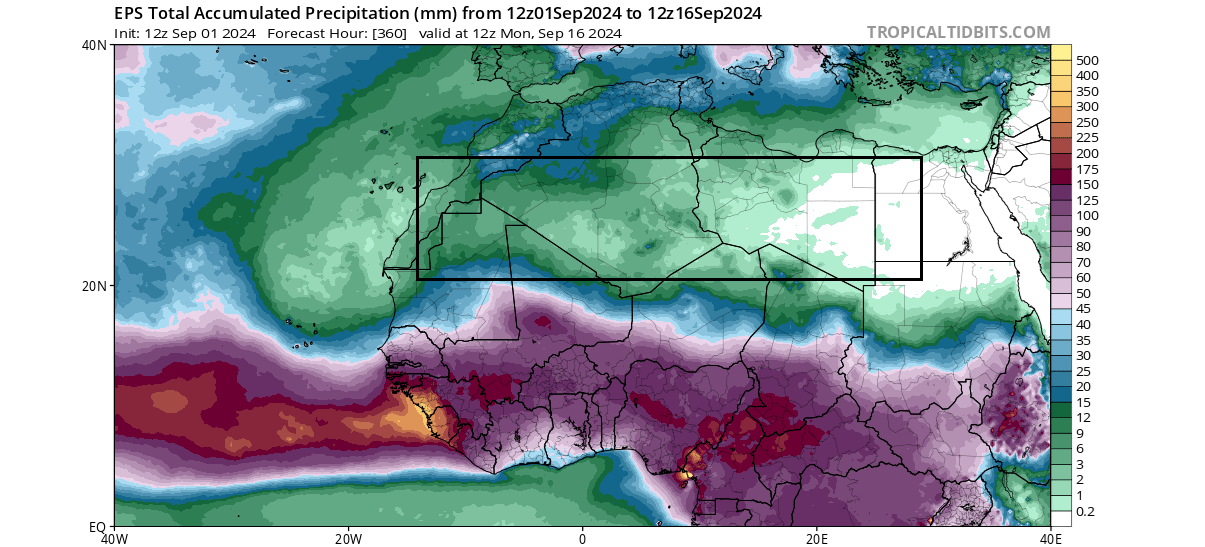
Looking at the ECMWF ensemble total precipitation for the first half of September, we can see that actual total amounts are perhaps not super high. Again, it shows us that many regions are forecast to get a few years worth of rain in the next two weeks.
The ECMWF extended precipitation anomaly for the second half of September does not show widespread anomalies. But, above-normal precipitation is still clearly visible in the desert areas. As this is an ensemble average, the forecast strength will increase as this period gets closer.

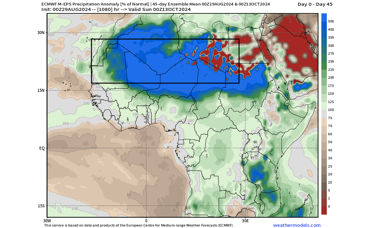
Looking even deeper into September, the image below shows the forecast for the percentage of normal precipitation. As you can see, the Saharan desert is maxed out at 500% over a very large area. This indicates that central regions will get over 1000% of the normal rainfall in the coming days and weeks ahead.
With such strong anomalies, we have to ask the question, what causes such an extraordinary weather event?
A DISTURBANCE IN THE SYSTEM (NEW)
In 2023, a study was released by several authors, that addressed the precipitation changes in the sub-Saharan (Sahel) region. They discovered a connection between the warm ocean temperature anomalies over the Atlantic Ocean and the Mediterranean, impacting the precipitation patterns over the Saharan regions.
The image below is a simple calculated result showing the precipitation anomalies, with the Atlantic (A+) and Mediterranean(M+) waters much warmer than normal. There is an obvious signal that warmer waters are connected with increased precipitation events in the sub-Saharan region. This helps to change the ITCZ position and fuels the desert rain events.
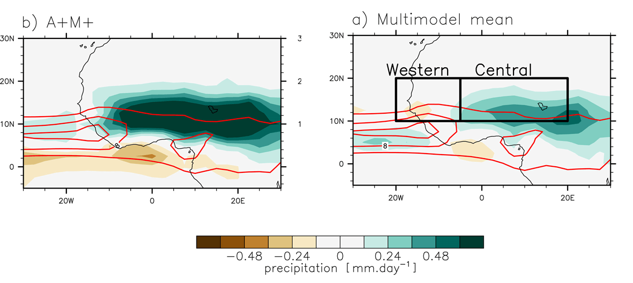
The image below shows the Ocean regions in question, marked in the North Atlantic and the Mediterranean. These areas are directly connected to atmospheric circulation, tropical pressure, and rainfall patterns over Northern Africa.

The latest ocean temperature analysis shows that both these areas are much warmer than normal. Based on the data from the study above, this nicely fits into the theory of the changing precipitation patterns over Saharan regions under such oceanic anomalies.

But how rare are these events really?
RARE WEATHER EVENT
We decided to produce a graph for precipitation over the Sahara, covering the month of August. You see the rainfall anomalies for each August in the past 53 years, with only four years showing a strong anomaly and more rainfall. With four events in the past five decades, it gives as less than one such event per decade.
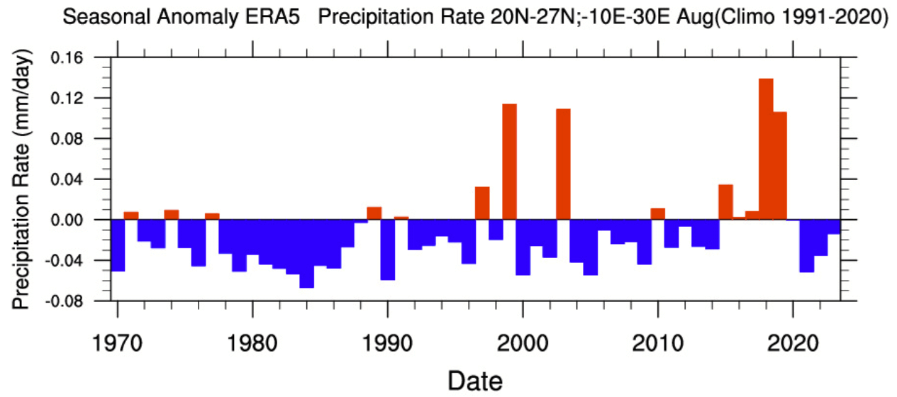
But this only gives us a general idea of how often more rain falls in the desert. The magnitude of this current event is not yet seen on these analysis graphs, but it is very likely that it will be the highest in several decades.
Because the precipitation forecast also shows strong anomalies in September, we decided to look at September data for the same period and area. As you can see, only one strong event occurred in 1994. We don’t have the 2024 data yet to understand the full context, but based on the forecast, it will be at least the second wettest year in the past decades.
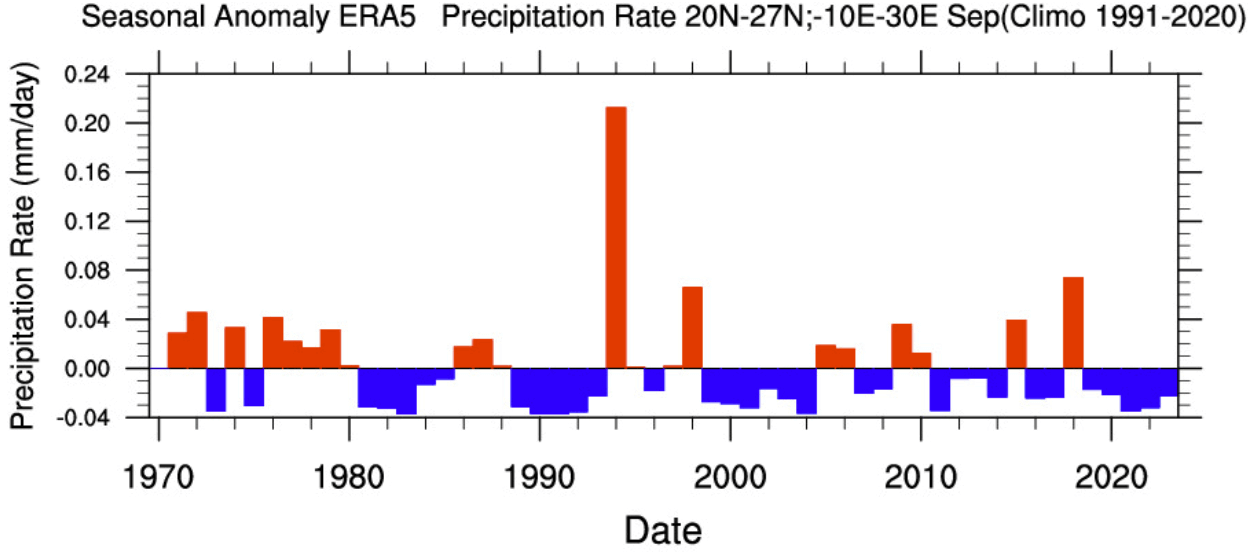
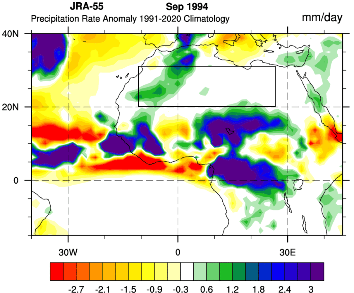
Looking closer at the 1994 precipitation anomaly, you can see that the overall anomalies were not as strongly widespread as you can see in some current forecasts for September. This could indicate that the current event could be placed very high in the history books, if not among the wettest years.
We have not yet completed our research on potential indications for Autumn or Winter across the United States or Europe. But one thing is certain: Such strong and rare weather anomalies can indicate a big instability of the global weather system.
We will keep you updated on the developing weather trends in the coming seasons, so make sure to bookmark our page. Also, if you have seen this article in the Google App (Discover) feed, click the like button (♥) there to see more of our forecasts and our latest articles on weather and nature in general.
Don’t miss:
Winter Forecast 2024/2025: First long-range Predictions from Seasonal Weather models