A major weather pattern change is finally coming up for Europe. An Arctic blast will spread from the north, leading to a significant and progressive pattern. Developing multiple intense winter storms that will rapidly move across Europe. Heavy rain, heavy snow, and blizzard are forecast.
After weeks of blocking High dominance over the European continent, the weather change is here. The rest of November will be characterized by a much more dynamic weather pattern, with multiple intense winter storms crossing the continent.
An extensive upper trough will emerge over Europe due to the intrusion of much colder weather from the Arctic region towards the south. Its lobes will rotate across the continent until late this month, causing intense frontal systems with heavy snow and strong winds.

So, this large trough will be the dominant feature for the rest of November, while the blocking High will establish over the North Atlantic, allowing cold airmass to maintain with the meridional flow from the north towards the continent.
This Sunday, the water vapor and air mass satellite across Europe and the Atlantic revealed a stable pattern over the Atlantic Ocean and Greenland. A large trough is already strengthening across northern Europe, and cold airmass is gradually spreading between it and the continent.
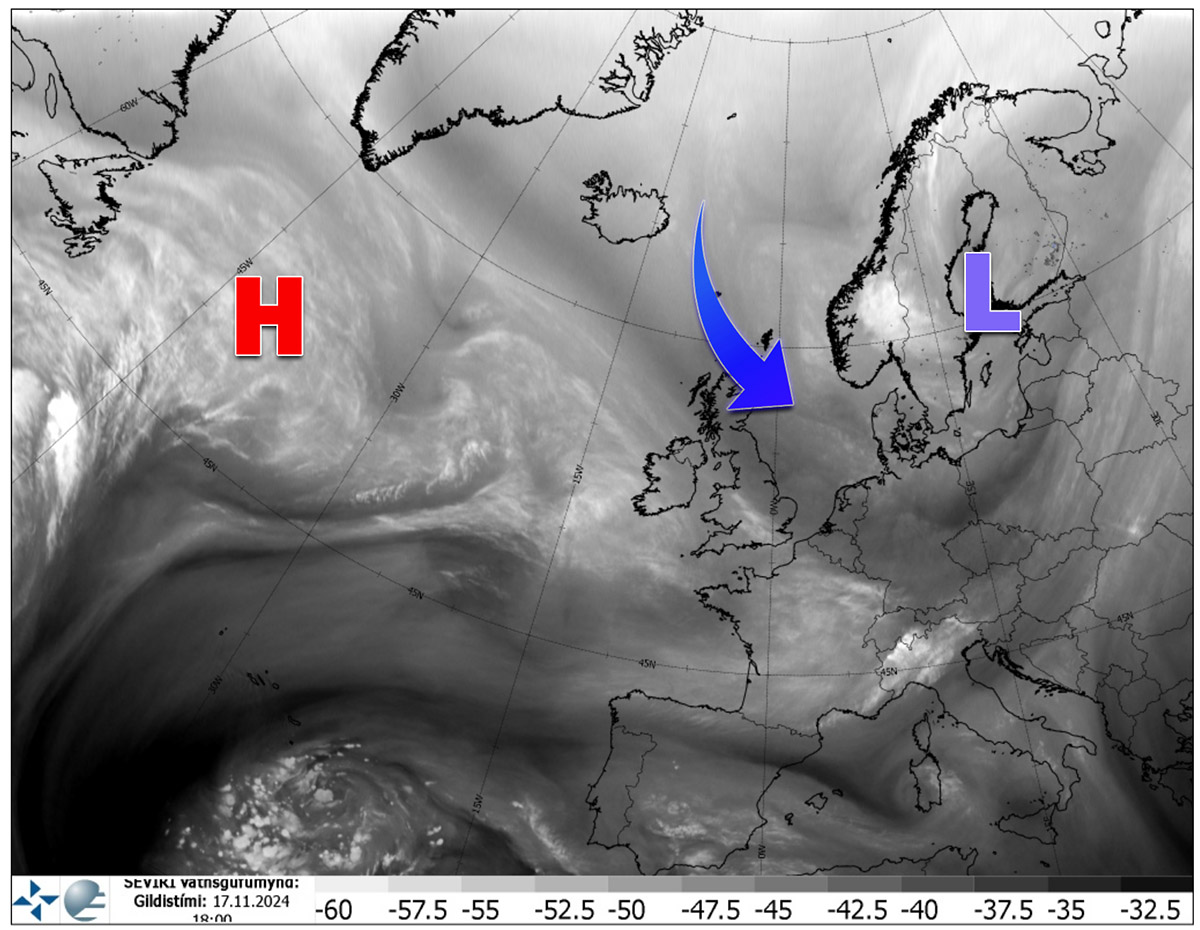
This will change the general weather pattern over the continent by Tuesday when the first system emerges from western Europe into northern Europe. The dynamic pattern over Europe is greatly seen in the following video animation.
Multiple weather frontal systems with winter storms will develop this week, bringing fresh snow to parts of western Europe, intense snow, and a blizzard over Sweden and Finland on Wednesday. Then, another deep low and snow blizzard will follow for the Alps and northern Balkan peninsula on Friday.
Conditions will deteriorate over Western Europe again over the weekend as a violent North Atlantic storm is forecast to impact Ireland and the UK.
Let us discuss the upcoming pattern evolution and forecast for each winter storm this week.
Major weather change forecast for Europe; progressive winter pattern develops
A large upper-level trough will establish over the European continent by mid-week, dominating the weather pattern. If we remember the first half of November, Europe was under an extensive Omega blocking High; it will now be a completely flipped pattern.
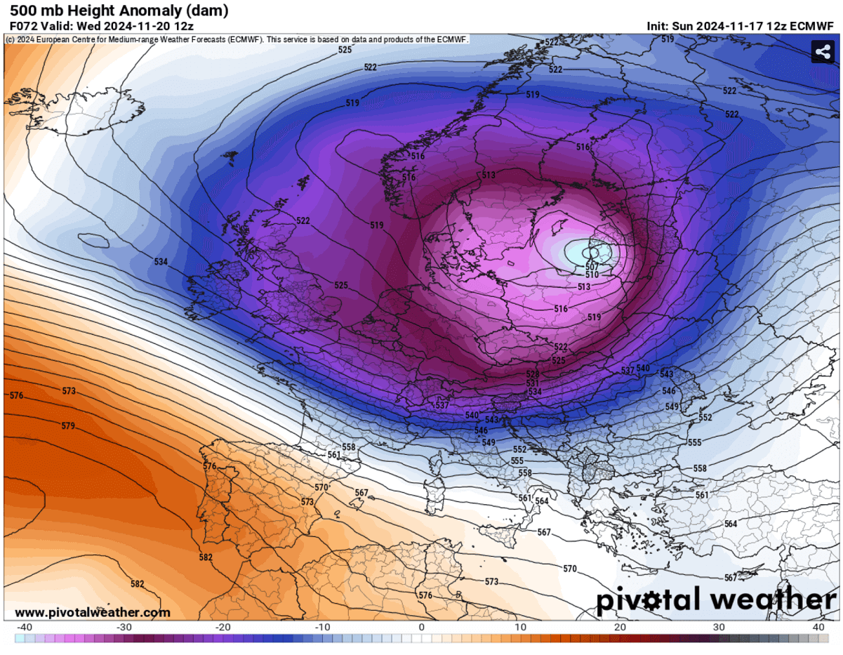
On Wednesday, the trough will be centered over northern Europe, with a large blocking High over the Azores. Thus, the two large-scale features will result in intense jet stream upper winds in between.
The intensity of the established flow can be seen on the following chart for winds at 500 mbar geopotential level, roughly 8 km above the ground. The core of the jet stream will bring violent winds, with 130-150 knots.

The maximum intensity of jet wind will help those flying eastbound by reducing their flight times. Those traveling westbound will experience more turbulent flights and longer travel times.
The large trough will allow Arctic airmass to advect across the Atlantic into Western Europe through mid-week, then gradually progressing east and south towards the next weekend.
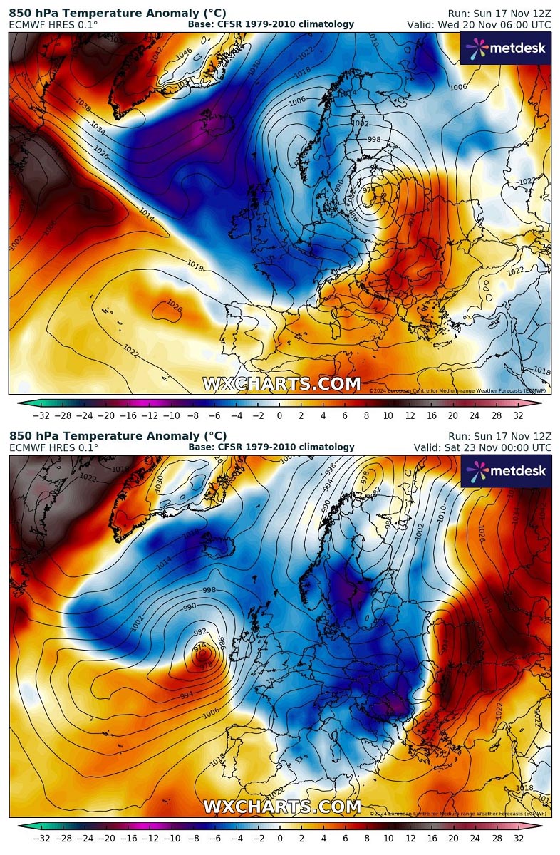
Therefore, it will establish conditions for precipitation into snow for many regions.
A powerful winter storm will blast Sweden and Finland with intense snow blizzard on Wednesday and Thursday
Under the core of the upper trough, a significant surface frontal system will develop from the UK into Benelux and Germany on Tuesday, rapidly moving northeast towards Poland and Sweden. Gaining strength, fed by the very cold upper levels aloft.
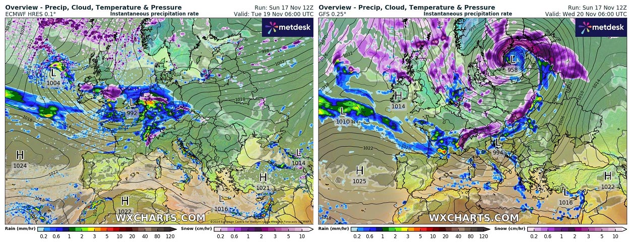
Surface pressure will significantly deepen as the system moves onto the Baltic Sea region. With nearly explosive intensification, the central pressure will be pushed below 960 mbar by Wednesday morning.
While the main cold front will be fast-moving east on Wednesday and dragged towards the Alps and the Balkans, conditions near the core of the surface low will be intense.
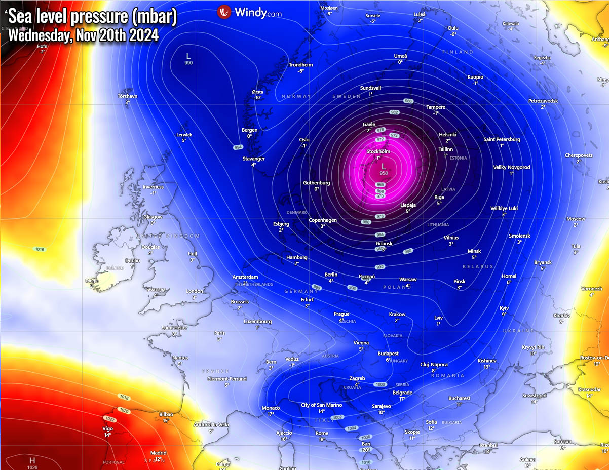
Heavy snow will develop on the cold side of the frontal system as it moves towards southern Sweden on Wednesday morning. Warm advection ahead of the low will spread into the Baltic region, but the air mass will remain cold enough to support snow at least over Estonia initially.
The system will gradually move northeast across the Baltic Sea, worsening heavy snow and blizzard conditions across southern Sweden throughout Wednesday. Heavy snow with strong winds will support near-blizzard conditions further north across central Sweden and south Finland by Wednesday night into Thursday morning.
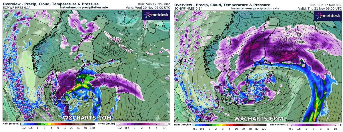
On Thursday, the center of the low will mature and begin weakening while moving east into the Baltic countries. It will be a cold, wintry day with widespread snow showers in the region. Heavy snow will continue farther north, thanks to western Russia’s advection of moist airmass.
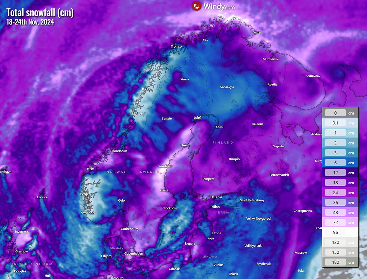
Most Scandinavian countries will receive significant snow through the next weekend. However, this deep low across south-central Sweden and southern Finland will produce the highest amounts.
Quite some snow is also forecast across parts of the UK and Ireland earlier on Tuesday and Wednesday. Associated with a rapidly organizing winter storm under the strengthening cold lobe aloft, at least northern England and Scotland will see some decent amount of snow.
Heavy snow will be possible, though the amount of snow that accumulates strongly depends on the position of the low on Tuesday.
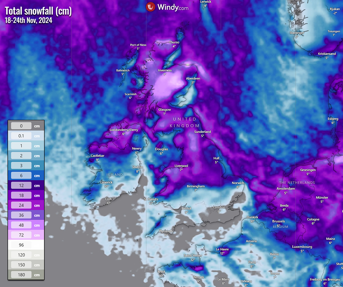
Some snow will also be possible across Ireland and Wales.
Intense Winter Storm expected to impact the Alps and northern Balkans with heavy snow and blizzard on Friday
Late this week, the focus on the significant winter weather will shift further south as another cold lobe of the large low aloft digs deeper onto the continent. An even larger and deeper geopotential heights overspread two-thirds of Europe.
This will allow the system to drag much colder air mass further south towards central Europe and the Alps.

In response to the cold advection aloft, an intense secondary Lee cyclone will form in the wake of the Alps, a typical pattern across the northern Mediterranean. A deep surface low will occur across north Italy, moving across the Adriatic Sea and the Balkan peninsula.
According to the latest weather model guidance, the central pressure is likely to drop below 990 mbar on Friday. This normally creates significant severe winter weather across the northern Mediterranean region.
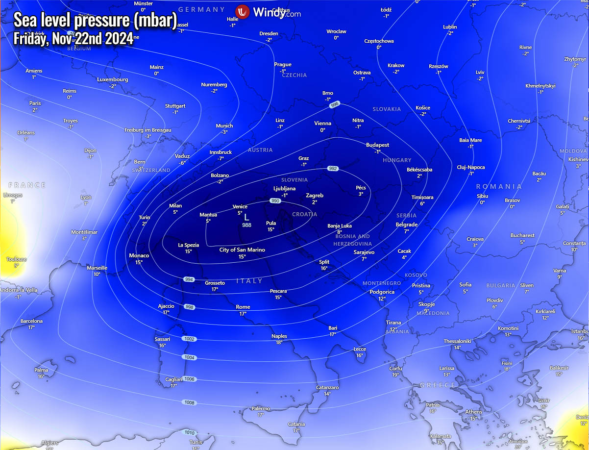
By Thursday night, the surface cyclogenesis occurs across the northern Mediterranean when the cold airmass reaches the western Alps. A rapidly developing cyclone will deteriorate weather conditions, with heavy rainfall across north-central Italy and the north Adriatic region, including severe thunderstorms with flash floods.
Heavy snow will fall over the Alps overnight and possibly along the Dynaric mountain rain across the northwestern Balkan countries. This, however, strongly depends on how deep and strong the cold air pool remains to the east of the range from the first frontal system on Wednesday.

It is possible that warm advection ahead of the developing low will be pretty strong, so precipitation will be rain, which could also lead to freezing rain on early Friday.
On Friday, heavy rain will be associated across the warm sector over central Italy and west-central Balkan peninsula countries ahead of the moving cold front. On the cold side, heavy snow will likely follow over Slovenia and Croatia on Friday. Blizzard conditions could develop locally, as strong Bora downslope winds will be in place.
This potentially significant winter storm combo is visible on the meteogram for Postojna, Slovenia (in the country’s southwestern part). Notice the first front crossing with a significant temperature drop on Wednesday, followed by intense precipitation on Thursday night into Friday. In contrast, temperatures remain well-below freezing at 850 mbar (about 1200m above sea level).

If verified, this would bring a significant snow blizzard and high snowfall accumulation across parts of Slovenia and Croatia, as seen on the total snow chart below. 15-40 cm of fresh snow will be possible in some areas.
Notice that a lot of snow could accumulate across the western Alps and the Balkan countries, including Austria, Hungary, and western Romania.

However, it depends on which track the secondary surface low takes. A more northerly track would bring stronger warm advection and more precipitation as rain. In contrast, the more southerly trajectory would bring colder weather and less snow as the main moisture remains over the Balkans.
Violent Atlantic storm forecast to impact Ireland and the UK over the weekend
Towards the end of the week, a deep trough over Europe gradually weakens while drifting east. A blocking High develops over southern Europe, bringing warmer airmass back into southern Europe and towards the Balkan peninsula.
However, further west and north, an intense upper trough emerges from the Atlantic into western Europe. Its core is forecast to be significantly deep, leading to a powerful frontal system towards the surface on Saturday.

The GFS and ECMWF weather models hint at a violent Atlantic storm blasting into Ireland and the UK on Saturday, with a deep surface low and pressure into the 950s mbar range.
Ahead of this large low, strong, warm advection is foreseen at the nose of the strengthening high-pressure system over the Mediterranean.
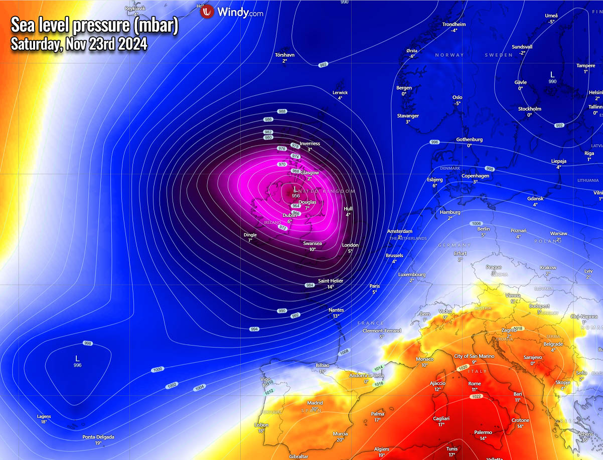
A violent storm will cross Ireland and the UK on Saturday, with heavy rain squalls associated with the cold front. However, some heavy snow could still be possible across Scotland, as cold will remain in place from days earlier before strong warm advection takes over.
Deep low is forecast to have its center to the west of Ireland. Violent winds and significant waves could blast the coast of Ireland on Saturday.

In some areas, this storm will bring strong to severe winds, possibly up to 150 km/h. The system is forecast to be large, thus impacting most of Western Europe over the weekend.
gusts
Windy, PivotalWeather Wxcharts provided images used in this article.
See also: The impact of a La Niña event on Winter Snowfall across the United States and Canada