Meteorological Autumn is just around the corner. Looking at the latest seasonal forecast, we can see clear signs of a weak La Niña emerging. Its influence will spread on the Autumn weather patterns across the Northern Hemisphere, especially North America, which will continue into Winter 2024/2025.
The meteorological Autumn covers three months, from September to November. This is the transition season from the warmest to the coldest part of the year.
As mentioned, an important player for Autumn weather this year will be the La Niña, which has a known history of Autumn and especially Winter impacts. So, before going into the forecast, we will quickly look at how La Niña works and what its history of impacts can show us for the future.
WEAK LA NINA RETURNS
La Niña is a cold phase of the large and powerful oceanic ENSO oscillation. It is a region of the tropical Pacific Ocean that shifts between cold and warm phases. The cold ENSO phase is called La Niña, and the warm phase is called El Niño.
These ocean temperature anomalies (warmer or colder) occur in specific regions of the Pacific Ocean, as shown in the image below. The main regions are 3 and 4, together covering a large part of the equatorial Pacific.

Looking at the latest ocean temperature anomaly analysis, you can see these colder-than-normal surface waters in the central and eastern ENSO regions. These cold anomalies have a “wave-like” shape. This is because of the strong easterly trade winds that push the waters towards the west, creating swirls on the ocean surface.

A big part of this process is the temperature anomaly below the ocean surface. You can see that in the image below from NOAA, which shows subsurface data, revealing a large cold ocean anomaly in the eastern and central Pacific Ocean.

Below is a high-resolution animation that shows the ocean temperature anomaly change across the ENSO regions in the Pacific this past Spring. You can see the shift from the warm ocean anomalies into more cold areas starting to appear. This was the rapid breakdown of the warm ENSO phase and a shift towards a new cold phase.
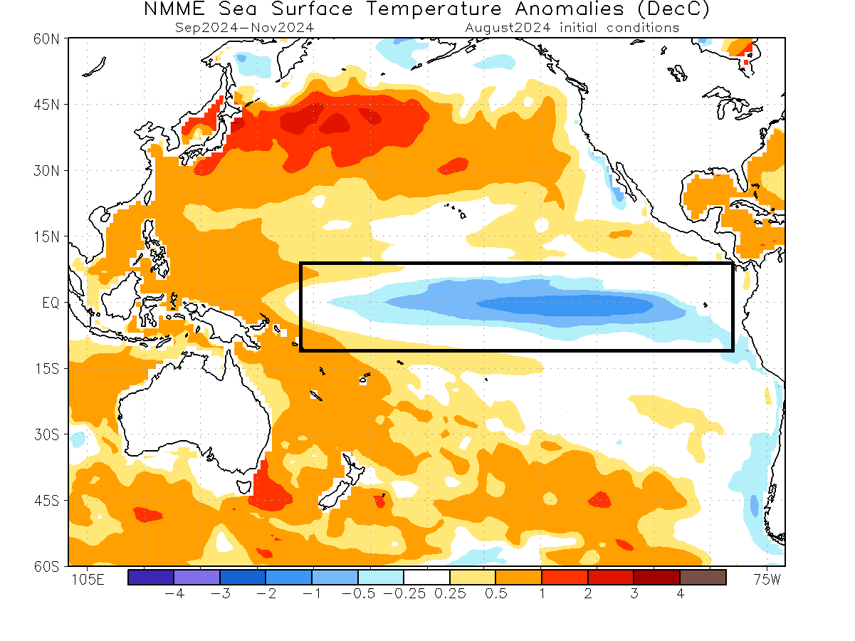
Below is an analysis/forecast image from NMME, which shows the temperature drop as the warm phase ended and the forecast of the main ENSO 3.4 region. You can see the continued negative anomalies and cooling forecast over the Autumn and Winter of 2024/2025. The forecast average is within the La Niña threshold, but it’s weaker than last month.
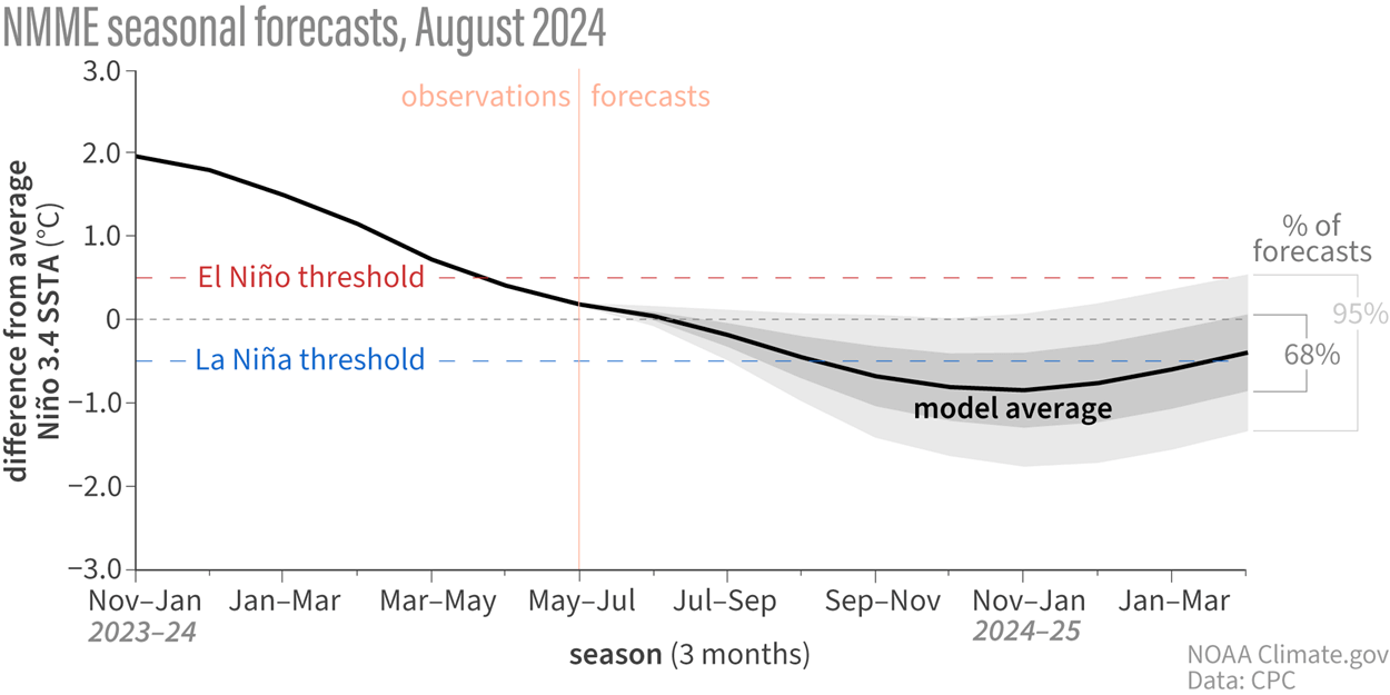
The actual ocean temperature forecast for Autumn from NMME shows that a La Niña anomaly is present. It is not as strong as some from past years, but it is strong enough to impact both the ocean and the atmosphere, as we will see in the forecast part of the article.
This data gives us enough confidence that we will see some influence from these anomalies over the coming cold weather season. But how does an ocean anomaly impact the weather worldwide?
WEATHER PATTERNS IN A LA NINA AUTUMN
Several autumn/Winter seasons have had an active La Niña phase. This gives us an opportunity to analyze past data to see how the Autumn weather patterns usually develop under a La Niña.
ENSO phases significantly influence tropical rainfall, pressure patterns, and the complex energy exchange between the ocean and the atmosphere. The image below shows the circulation pattern of La Niña and its connection to the ocean and the atmosphere.
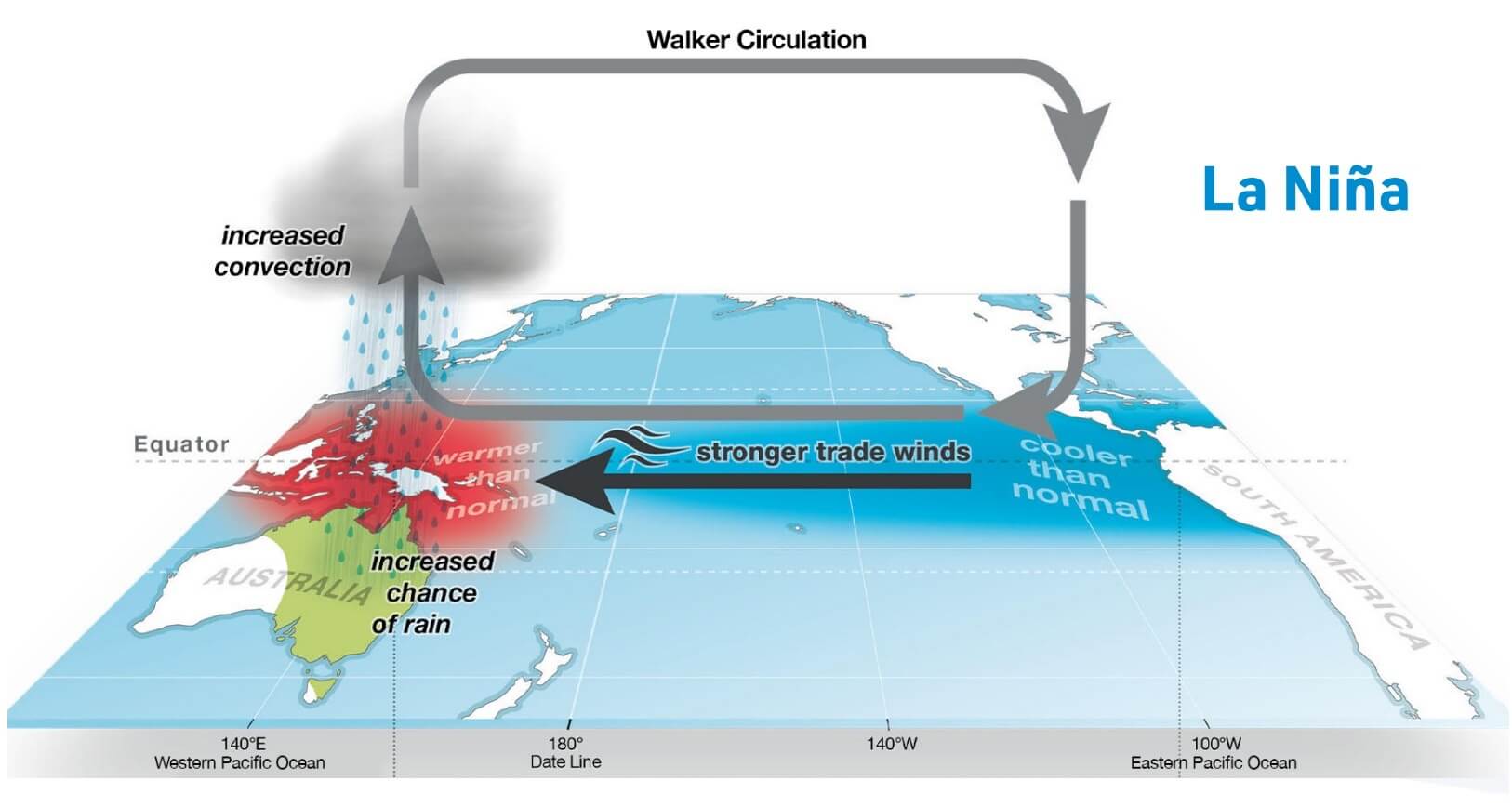
This way, the ENSO significantly impacts tropical rainfall and pressure patterns, altering the atmosphere-ocean feedback system. The ENSO influence is spread globally through this system, changing the Winter temperature and snowfall patterns over the Northern Hemisphere.
In essence, you could also say that these ocean anomalies act like control lights on the dashboard of your car. So, they not only have their own influence but also signal the overall state of the atmosphere.
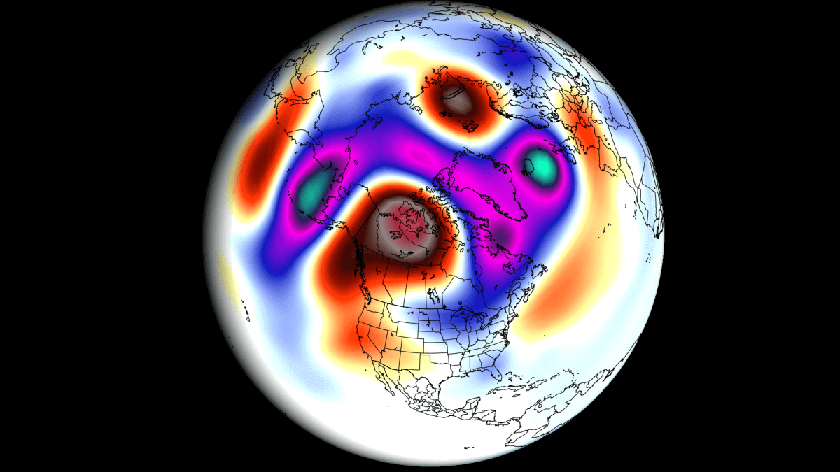
Below, we produced special graphics showing the connection between the ENSO and pressure anomalies in September-December. Simplified, it shows the prevailing signal during an active ENSO phase. In this case, the colors represent a La Niña signal.
First, we have the pressure pattern, covering the Autumn and early Winter period. The two features that stand out are the North American and North Atlantic pressure patterns.
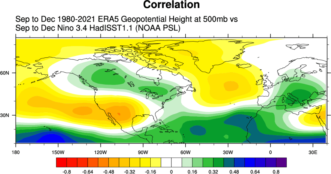
In the North Atlantic, a high-pressure system extends from the ocean up north into Greenland. West of it, a lower pressure area covers Canada and the northeastern United States, and a high-pressure system extends from the North Pacific into the southern United States.
This later brings the jet stream further down into the northern United States as Winter starts, but more on this in our early Winter forecast article next month.
Next, we have the temperature patterns. The below-normal temperatures over Alaska and parts of Canada are expected due to being under a low-pressure area. The western United States is warmer, with cooler anomalies trending towards the northeastern and far northwestern parts of the Country.

There is a cool signal over most of Europe due to the prevailing northerly flow from the high pressure in the North Atlantic. But, the ENSO phases do not directly influence the weather patterns over this region as they do over the United States and Canada.
Precipitation patterns in a La Niña Autumn season are very “two-faced”. We can see a drier-than-normal pattern over most of the central and southern United States and wetter conditions over the northwestern and far northeastern United States and Canada.

Over Europe, we see a drier trend over the west and more precipitation in the central/east parts. So we have quite obviously separated precipitation patterns.
Knowing what La Niña is and how it can change our weather seasons, we will now look at the actual predictions to see if we can find its influence on the coming Autumn 2024 weather season.
AUTUMN 2024 LONG-RANGE FORECAST UPDATE
For the Autumn 2024 forecast, we will look at the two main (or most used) seasonal models: The ECMWF model from Europe and the NMME, a combined forecast from several different North American models. Forecast images are from the Copernicus Climate EU project and the NCEP.
All these forecasts are an average picture over three months (September-October-November) and show the general prevailing weather pattern forecast for the meteorological Autumn. This only shows/implies how the weather patterns might look 40-60% of the time during the weather season.
Long-range/seasonal forecasts can never be deemed “reliable”. Here, we only look at trends and how weather patterns might evolve on a large scale, so we don’t use this long-range data to forecast weather in a specific city on a specific day and hour.
The latest pressure pattern forecast shows signs of a weak La Niña presence: a high-pressure system in the North Pacific, with another high-pressure area over the western United States. Low-pressure systems can be found over Alaska and also over northern Europe.
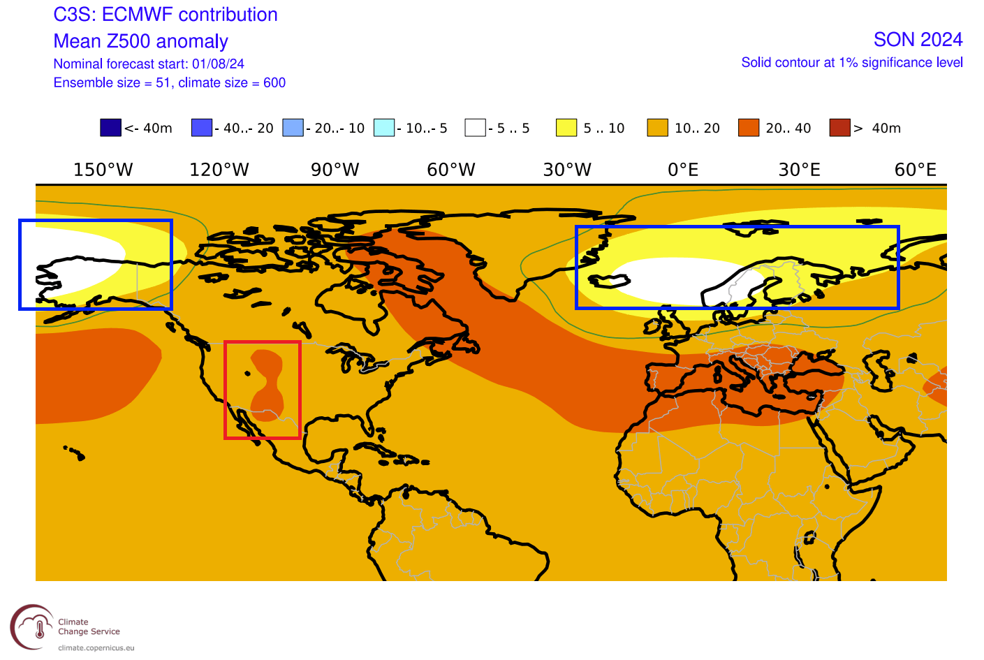
A high-pressure zone extends from eastern Canada across the Atlantic and into Europe. This can influence the weather pattern over the eastern United States and upper Midwest and could limit the highest temperature anomalies to the west and southwest of the United States.
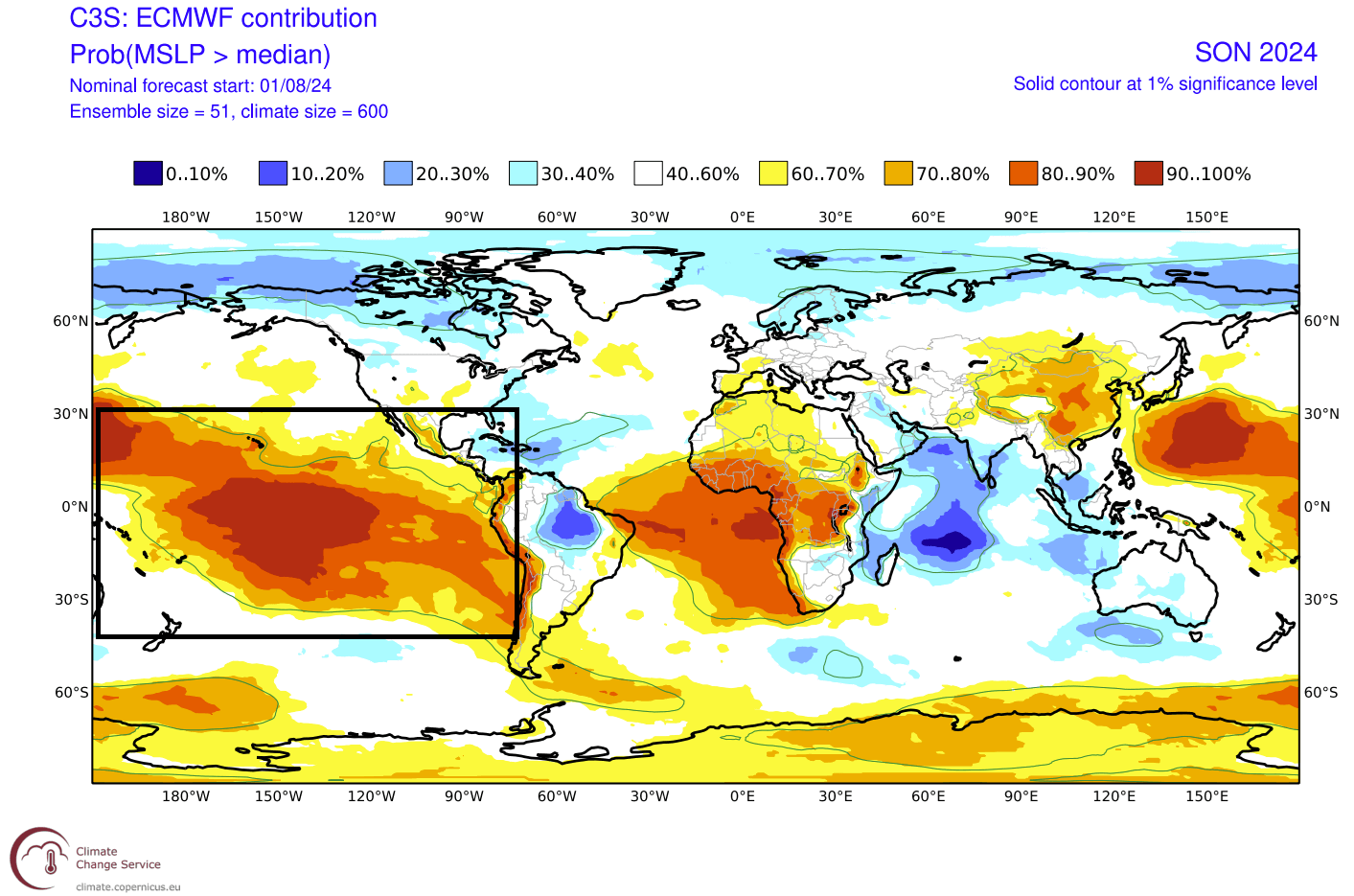
The surface pressure anomaly also shows an interesting pattern over the tropical Pacific. A broad high-pressure area is forecast to cover the region, indicating a La Niña-type pattern. This way, we can look for the La Niña influence on the tropical surface-level circulation, confirming its presence in the atmosphere.
TEMPERATURE AND PRECIPITATION FORECAST
Looking at Europe, we can see warmer-than-normal surface temperatures over much of the continent. This is due to a high-pressure area over the North Atlantic extending into Europe that the ECMWF pressure forecast shows. The influence of a low-pressure area can be seen over the northwest, bringing a milder airmass into the United Kingdom and Ireland.

The precipitation forecast shows a drier Autumn over much of southern Europe. At the same time, a low-pressure zone is forecast to bring more precipitation to northern parts and over the United Kingdom and Ireland, as well as more rainfall into central parts.

Over the United States, we see the core of the warmer temperatures over the west, under a high-pressure system. Warm anomalies also extend into the eastern United States and eastern Canada. But we do see an area of lower anomalies over the Midwest, as indicated by the pressure forecast.

Looking at precipitation, we have wetter conditions over the northwestern United States, the East Coast, and parts of the upper Midwest. Less precipitation than normal is forecast over the southern half of the United States under the influence of a broad high-pressure system over the southwest.

It is interesting to see more precipitation in the Gulf of Mexico and in the western Caribbean. This is part of the tropical systems development region. This could be seen as a potential signal for more tropical activity later in the Hurricane season.
AUTUMN 2024 SNOWFALL FORECAST
Looking at snowfall forecasts in Autumn might be a bit of a stretch, but November is the last month of Meteorological Autumn. This month is already deep enough into the year to bring some cold air and potential snowfall in strong cases.
Below is the ECMWF snowfall forecast for Europe, which shows less snowfall than normal for much of the continent. Some areas show a bit more snowfall, like elevations of Scandinavia, due to a westerly flow with the low-pressure area. Some snowfall areas are also seen over the Alps and northern Balkans.

The November snowfall forecast for North America shows increased snowfall amounts over the western United States, most likely above certain elevations. More snowfall is also forecast over western Canada. Less snowfall is forecast for much of eastern Canada, the plains over the United States, the Midwest, and the northeast.

NMME AUTUMN 2024 FORECAST UPDATE
NMME model system stands for North American Multi-Model Ensemble (NMME). It combines several individual models to show an average picture from different solutions.
This forecasting system covers more scenarios, but the drawback is that the forecast image can get heavily diluted at longer ranges. That is due to the strong differences in the forecast, produced from different models in the mix.
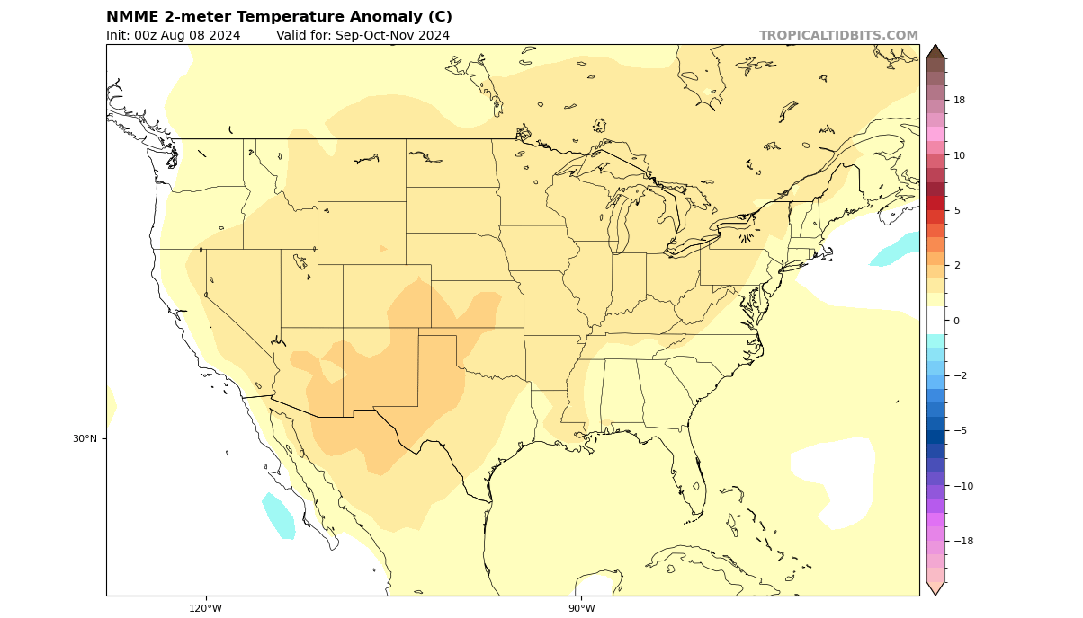
The temperature forecast for the United States and Canada below shows a warmer Autumn over the western and southwestern parts of the United States. Parts of the Midwest, the eastern United States, and the Northeast all show weaker anomalies, in line with the expected La Niña influence.
The precipitation forecast for North America is very “diluted” due to many models in the mix. But the main trend and idea is very similar to the ECMWF forecast above: Less precipitation is likely over the southern and southwestern United States, and more is likely precipitation is likely over the northwest and the east coast.

This again shows some support for the ECMWF forecast, which does trend toward a weaker but visible La Niña influence in the overall Autumn 2024 weather circulation.
AUTUMN 2024 OFFICIAL OUTLOOK UPDATE
Below is the latest official Autumn 2024 temperature outlook from NOAA/CPC for the United States. The forecast shows a warmer-than-normal Autumn season over the western United States, with the belt of warm anomalies extending over the south and up into the northeast.

We can also see a neutral temperature zone in the upper Midwest. That does indicate a chance of more cold fronts coming down from the northwestern United States and western Canada into the plains and towards the eastern United States, as the low-pressure area over Canada gets stronger towards Winter.
It could also mean earlier snowfall than normal in the northern United States closer to Winter.
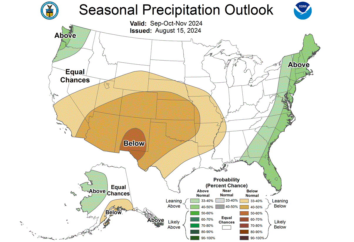
The NOAA Autumn 2024 precipitation outlook shows drier conditions in the western and central United States. Wetter conditions are expected mostly on the east coast of the United States and over the northwest.
This is a similar precipitation pattern to past La Niña Autumns. With this in mind, we can also quickly look at the usual winter weather pattern that follows such autumns.
ENSO AND WINTER WEATHER PATTERNS
As we examine the influence of the La Niña on Autumn, we can also see its impact on the Winter season. We will soon release a proper first Winter Forecast article, so this is just a general outline of La Niña’s influence on winter weather patterns.
Typically, the first influence of these ocean anomalies can be seen in the jet stream patterns changing. The jet stream is a large and powerful stream of air (wind) at around 8-11km (5-7mi) altitude.
Historically, a strong blocking high-pressure system in the North Pacific is the most typical effect of a cold ENSO phase. That usually redirects the polar jet stream down over the northern United States, along with the colder air.
Below is the average jet stream position in La Niña winters and the resulting weather patterns developing over the United States and Canada. It shows the redirection of the jet stream from western Canada down into the northern United States.

The displaced jet stream brings colder temperatures and winter storms from the polar regions down into the northern and northwestern United States. Warmer and drier winter weather prevails over the southern states.
The image below shows the average pressure pattern during the La Niña winters over the past 40 years. A strong high-pressure system is visible in the North Pacific, and a low-pressure area is over Canada and the northern United States. The images were produced with PSL tools.

The circulation of the strong high-pressure system promotes the development of a low-pressure region over Alaska and western Canada. It relocates the jet stream downwards between the two strong pressure systems, marked above by the blue lines.
The temperature analysis for the same winters as above shows the cold air anomaly under the jet stream in western Canada and the northwestern United States. A cooler area extends over the Midwest and into the south-central plains, creating a likely cold front path.
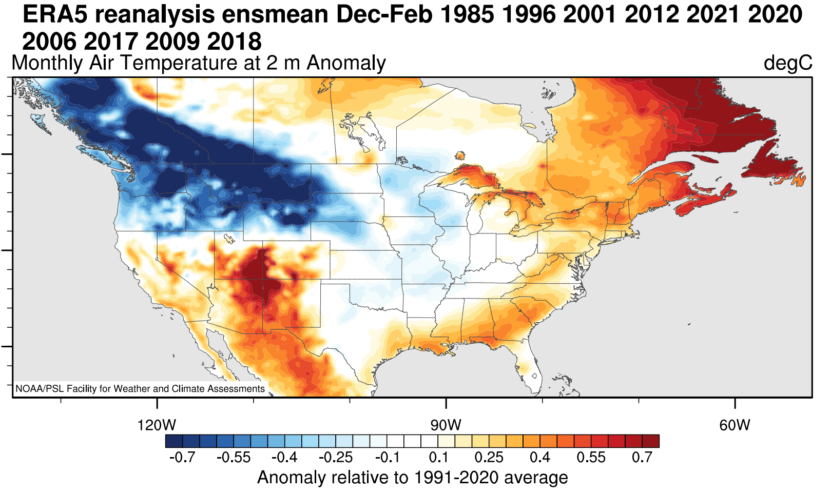
Warmer-than-normal weather and mild winter conditions typically develop over southwestern, eastern, and eastern Canada. The most dynamic winter weather usually occurs between the warm and cold anomalies in the Midwest and the central United States.
Looking at precipitation, La Niña winters are usually drier over the southwestern United States and Canada. Drier conditions also develop in the southeastern United States as La Niña produces a weaker subtropical jet stream and less moisture for the east. More precipitation is expected over the northwestern United States, the Great Lakes, and parts of the northeast.

The same changes occur with snowfall. Colder air is more easily accessible to the northern United States, increasing the snowfall potential when moisture is available. In the image below, you can see the average snowfall pattern for weak La Niña years, as expected for this Winter season.

In addition to the northwestern United States and the Midwest, there is increased snowfall potential over the northeastern United States and eastern Canada.
We will keep you updated on the global weather pattern development for the coming seasons, so make sure to bookmark our page. Also, if you have seen this article in the Google App (Discover) feed, click the like button (♥) there to see more of our forecasts and our latest articles on weather and nature in general.
SEE ALSO: