Winter 2024/2025 snowfall predictions show a global weather signal from a weak La Niña, now starting to appear in the Pacific, getting ready for Winter. From Canada to the United States and across the Atlantic to Europe, you will see the first Snowfall predictions and trends for the upcoming Winter season.
First, we will look at the leading global weather driver for the upcoming weather seasons, the La Niña. What does the latest ocean data show, and what are the expectations for the 2024/2025 season?
Then, we will examine the snowfall predictions month-by-month for the United States, Canada, and Europe, using the two leading global long-range forecasting systems.
GLOBAL SEASONAL WEATHER INFLUENCE
ENSO is a region of the equatorial Pacific Ocean that changes between warm and cold phases. Typically there is a phase change around every 1-3 years. The warm phase is called El Niño, and the cold phase is called La Niña.
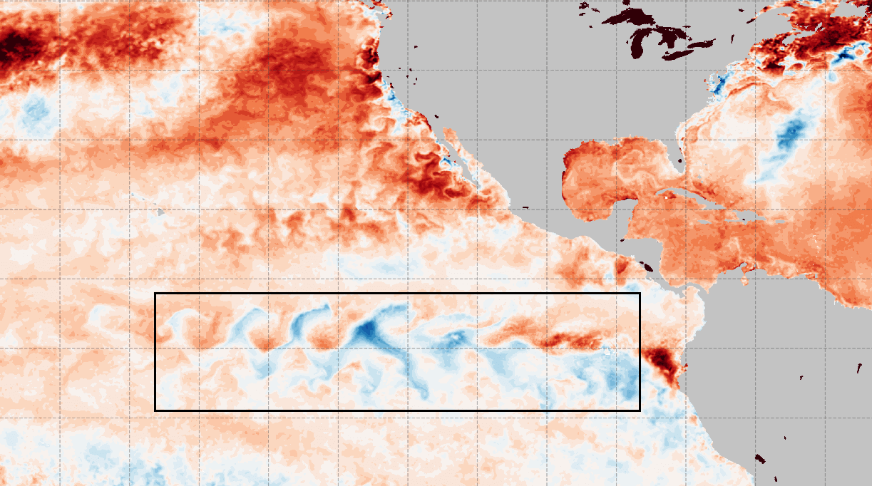
Below is NASA’s latest mid-August ocean anomaly analysis. It shows colder-than-normal surface waters in the central and eastern ENSO regions. These cold anomalies have a “wave-like” shape. This is because of the strong easterly trade winds that push the waters towards the west, creating swirls on the ocean surface.
ENSO phases significantly influence tropical rainfall, pressure patterns, and the complex dynamics between the ocean and the atmosphere. The image below shows the circulation pattern of a cold phase, which is currently developing.
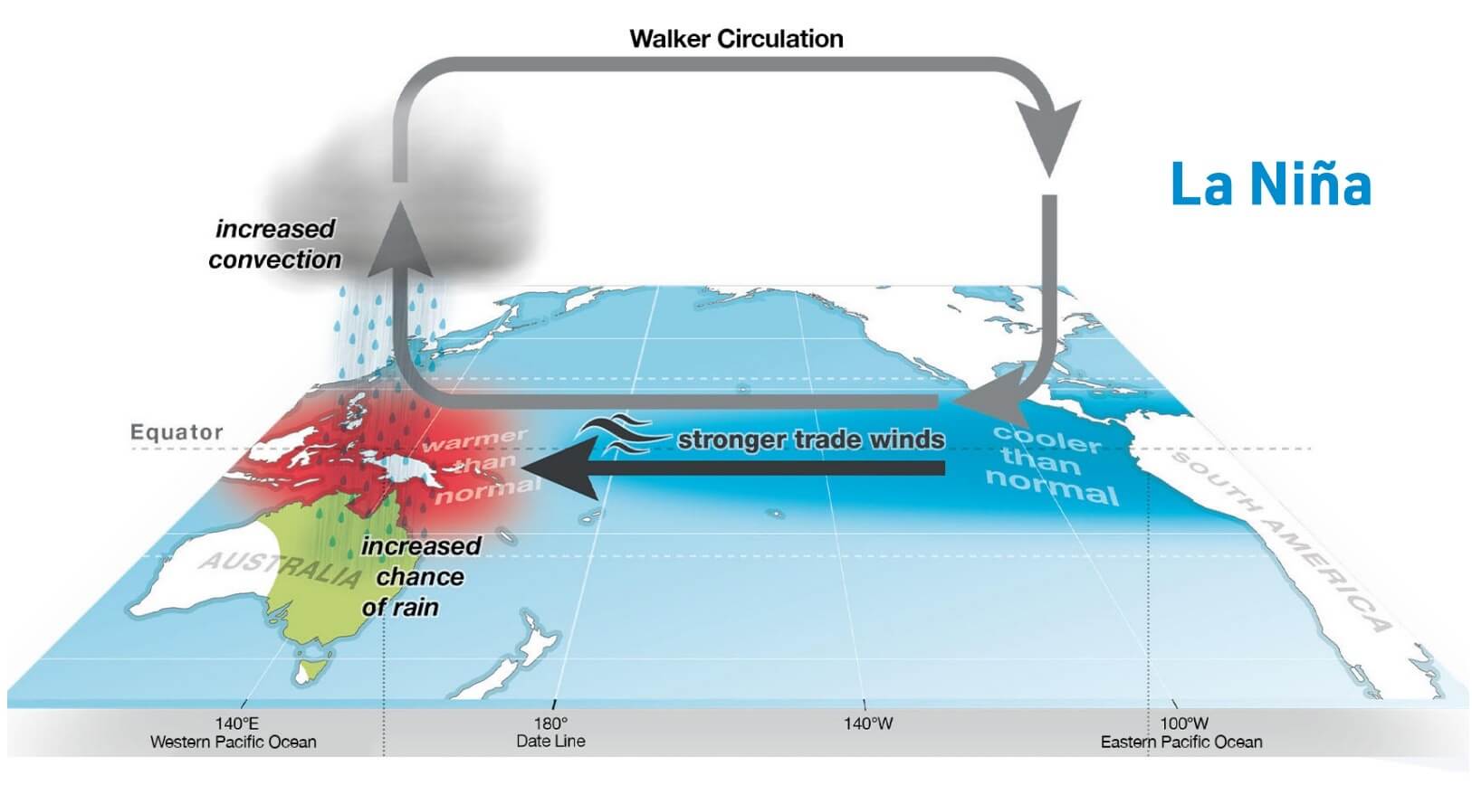
Changing the circulation, ENSO significantly impacts tropical rainfall and pressure patterns, altering the atmosphere-ocean feedback system. This feedback system spreads the ENSO influence globally, especially the Winter temperature and snowfall patterns.
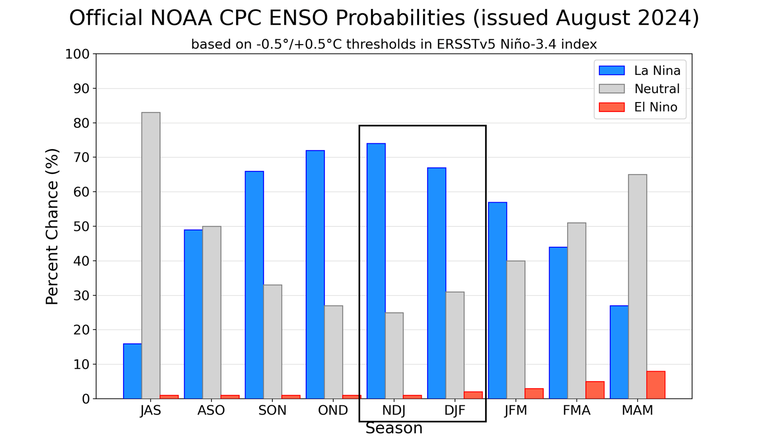
Below is an official CPC probability forecast image, showing the long-range forecast of the central ENSO region. As forecasted, La Niña conditions will last over the Fall and Winter. A weakening of the La Niña is expected early next year, with a shift to a neutral phase.
To better understand the ENSO changes, we produced a high-resolution video animation that shows how the ocean temperatures went from warm to cold anomalies across the ENSO regions in the tropical Pacific.
So, what exactly does this mean for the winter weather patterns and snowfall potential? We will take a closer look at the weather influence that La Niña usually shows over North America, as it has a more direct impact.
Europe is not known to have any specific/direct influences, as it is too far from the source. But that does not mean it has no impact.
La Niña does change the weather globally, but apart from the direct influence over North America, places like Europe have many other factors at play before any La Niña influence can spread this far.
NORTH AMERICA WINTER PATTERNS
The main influence of these ocean anomalies can be seen in the changing jet stream patterns. A jet stream is a large and powerful stream of air (wind) at around 8-11km (5-7 mi) altitude, flowing like an atmospheric river.
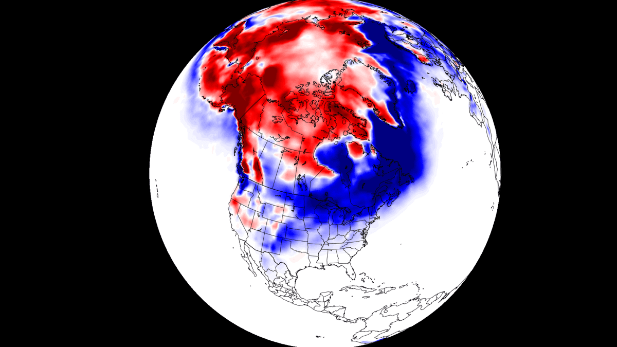
Historically, a strong blocking high-pressure system in the North Pacific is the most typical effect of a cold ENSO phase (La Niña). That usually redirects the polar jet stream down over the northern United States.
The circulation of the strong high-pressure system promotes the development of a low-pressure region over Alaska and western Canada. It pushes the jet stream downwards between the two strong pressure systems and is marked above by the blue lines.
The image below shows jet stream redirection from La Niña and the resulting weather patterns developing over the United States and Canada.

The displaced jet stream brings colder temperatures and winter storms from the polar regions down into the northern and northwestern United States. Warmer and drier winter weather prevails over the southern states.
Looking at the temperature analysis for the same winters as above, we can see the cold anomaly area under the jet stream in western Canada and the northwestern United States. A cooler area extends over the Midwest and down into the south-central plains.

Warmer-than-normal weather and mild winter conditions typically develop over the southwestern and eastern United States and eastern Canada. The main winter weather dynamics are usually between the warm and cold anomalies in the Midwest and the central United States.
Data also shows that the La Niña jet stream pattern significantly affects the snowfall potential over North America as the pressure systems take a different path.
The colder air is more easily accessible to the northern United States, which increases the snowfall potential when moisture is available. In the graphic below by NOAA-Climate, you can see the average snowfall pattern for weak La Niña years, as expected for this Winter season.
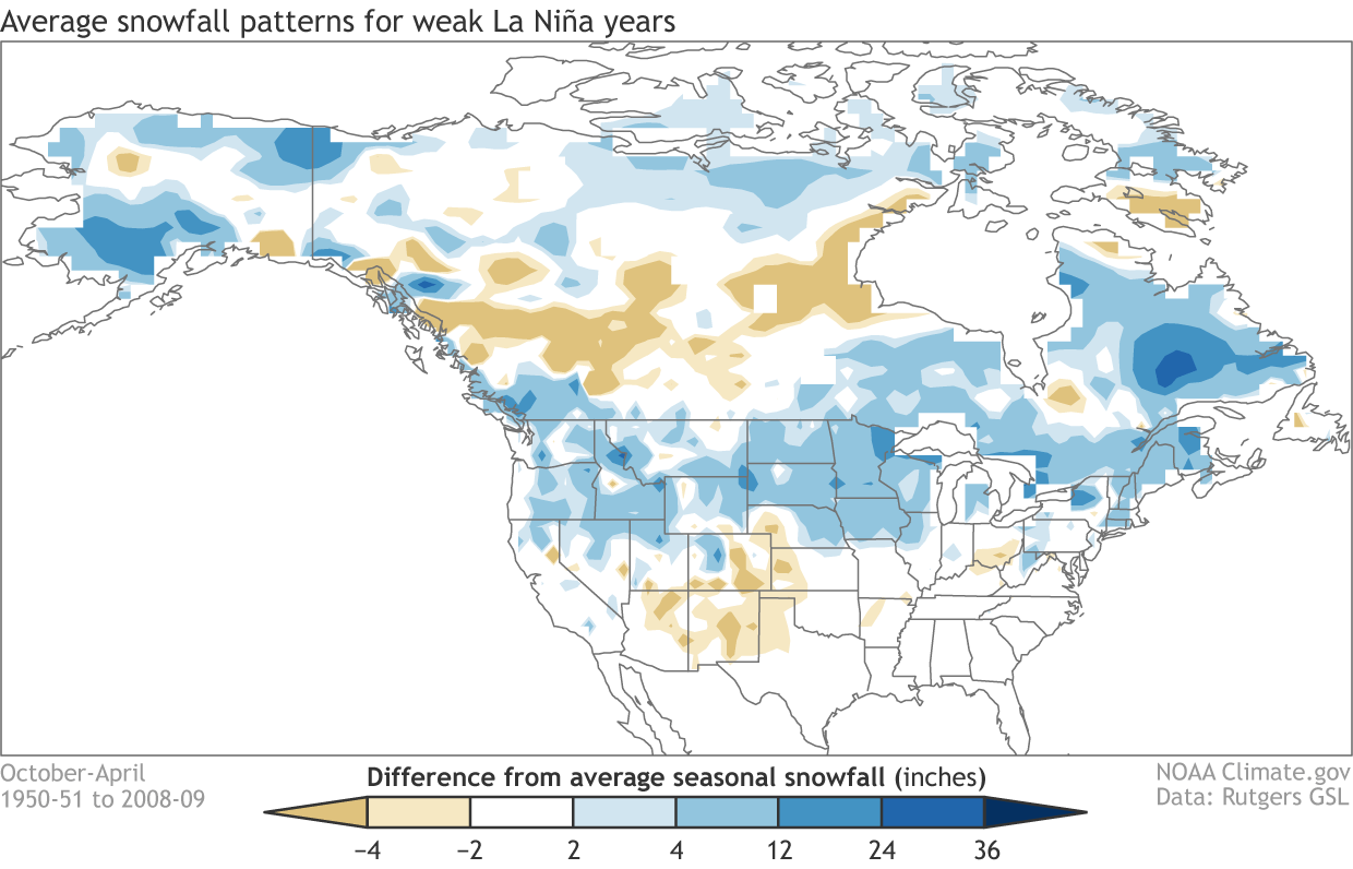
In addition to the northwestern United States and the Midwest, the northeastern United States and eastern Canada show more snowfall potential in such ENSO conditions.
It’s time for some actual Winter snowfall predictions from the latest forecast models. Since the latest forecast data was released in mid-late August, the February data is not yet included, but will be added in the next update as soon as data is available.
WINTER SNOWFALL PREDICTIONS
The format of this snowfall forecast is simple. We will look at two well-established seasonal weather forecasting systems, the ECMWF and the UKMO. The data used to produce these images is the latest available, from mid-August.
You will first see the average snowfall forecast for November-December-January, and then we will do a monthly breakdown. There are a lot of details in the monthly forecast that the whole seasonal average cannot show.
These forecasts show the snowfall anomaly, which means they show the areas forecast to receive more (or less) snowfall than normal. If an area is forecast to receive less snowfall than normal, it doesn’t mean it will receive no snow, just that less snowfall than usual is expected.
ECMWF WINTER 2024/2025 SNOWFALL FORECAST
We will start with the ECMWF, the most often used and highly regarded seasonal forecasting system.
First, the average forecast over Europe shows below-average snowfall. However, due to the influence of a local low-pressure system over the north, more snowfall than normal is forecast over Scandinavia.
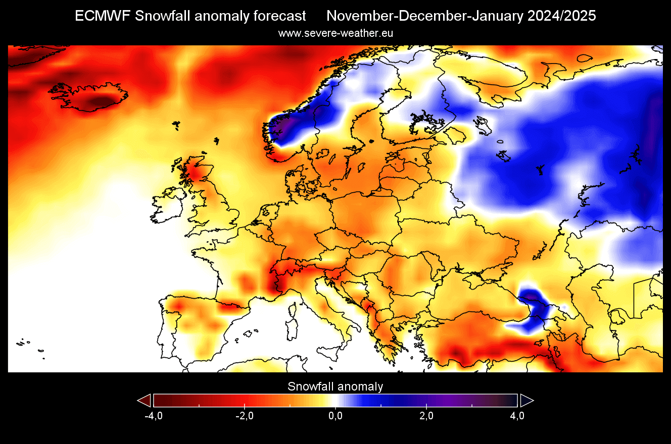
The November forecast also shows mostly below-average snowfall across Europe. Some potential for more snowfall is seen over the Alps and northern Balkans.

The December snowfall forecast shows less snowfall than normal over much of the continent. An area of more snowfall is over the Alps and again over northern Scandinavia.

The January forecast shows reduced snowfall potential over much of the continent. But an area of more snowfall is forecast to push into southeastern parts, likely due to a high pressure anomaly over the northwest.

NORTH AMERICA ECMWF SNOWFALL PREDICTION
The seasonal average shows that most of the United States is forecast with below-average snowfall. This is perhaps surprising, especially for the Midwest and the far Northeast, which usually get more snow in a weak La Niña winter.
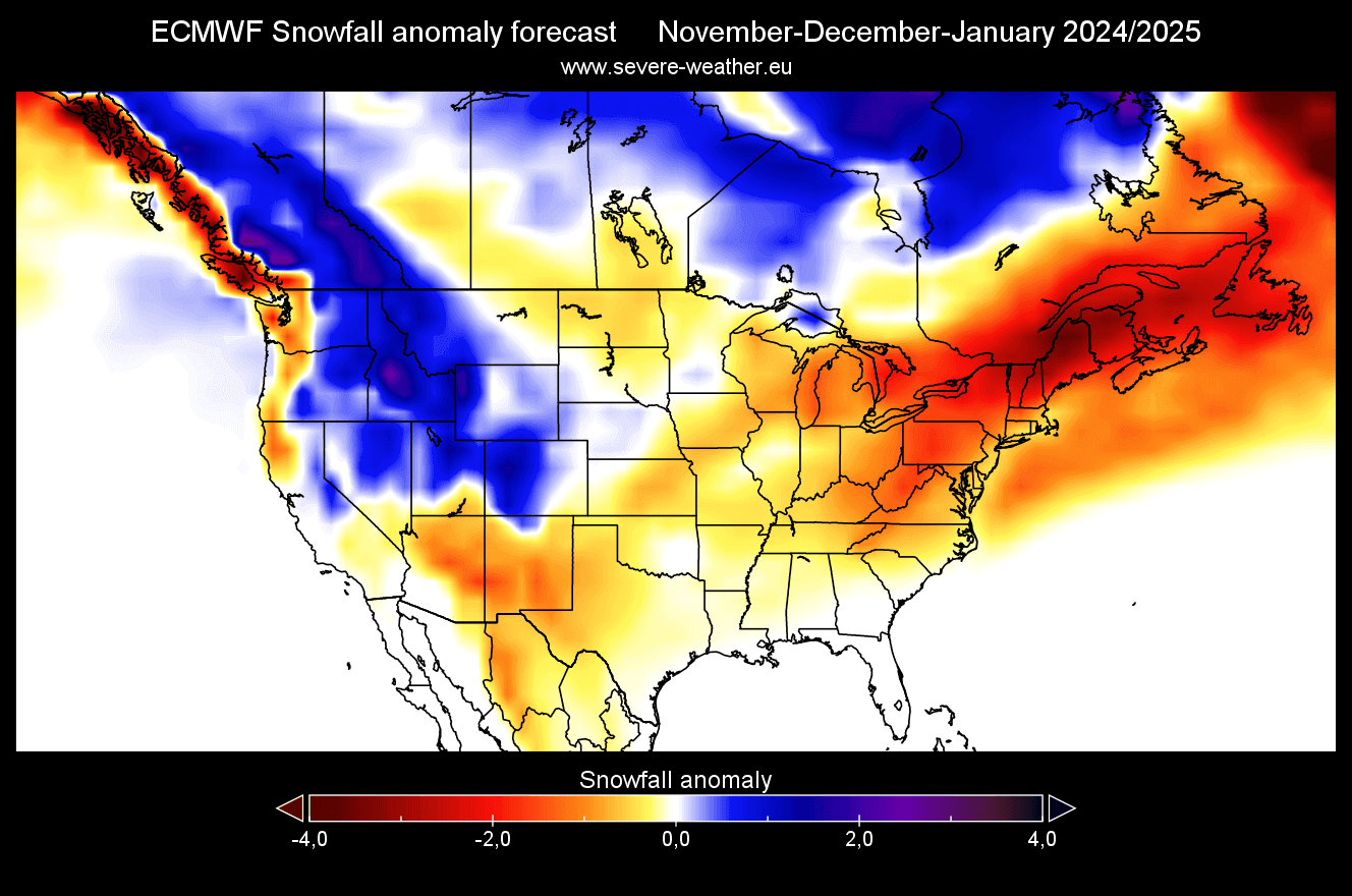
Canada shows more snowfall over much of the country, except for parts of the south and southeast. But remember that this is the first batch of long-range snowfall predictions, and there are many more details in the month-to-month patterns, especially in mid-to-late Winter.
The November snowfall forecast for North America shows increased snowfall amounts over the western United States, most likely above certain elevations. More snowfall is also forecast over western Canada. Less snowfall is forecast for much of eastern Canada, the plains over the United States, the Midwest, and the Northeast.

The December snowfall forecast shows some improvement. More snowfall is forecast over parts of the north-central United States and the upper Midwest. Less snowfall is still forecast over the far northwest and northeast of the United States, but an increased snowfall area is expanding over eastern Canada.

January snowfall forecast shows an interesting pattern. A strong area of above-normal snowfall is forecast over the west/northwest of the United States and the upper Midwest. More snowfall is also seen over much of Canada.

The January snowfall forecast from ECMWF still shows less snowfall across the eastern and southern United States. Overall, the January forecast looks similar to a more typical La Niña pattern, except for the Northeastern United States, which should usually get more snowfall in such a pattern.
UKMO WINTER 2024/2025 SNOWFALL FORECAST
As you can never trust a single forecast model, we use the UKMO long-range forecasting system along the ECMWF. It was developed by the United Kingdom Met Office, which is where the initials UKMO come from.
First, looking at the seasonal average for Europe, we can see another weak snowfall forecast identical to the ECMWF. Most of the continent is forecast to have less snowfall than normal, except for some northern parts.

The November forecast shows a below average snow potential over much of Europe. Again, more snowfall is forecast over the northern parts, just like in the ECMWF forecast.

The December snowfall forecast shows no major improvement except for the usual higher elevations of northern parts and a small area on the southern Alps and over the southeast.

No major change is forecast for January across the continent. As the forecast shows, snowfall potential is increasing down from the northeast, and some areas over the central parts.
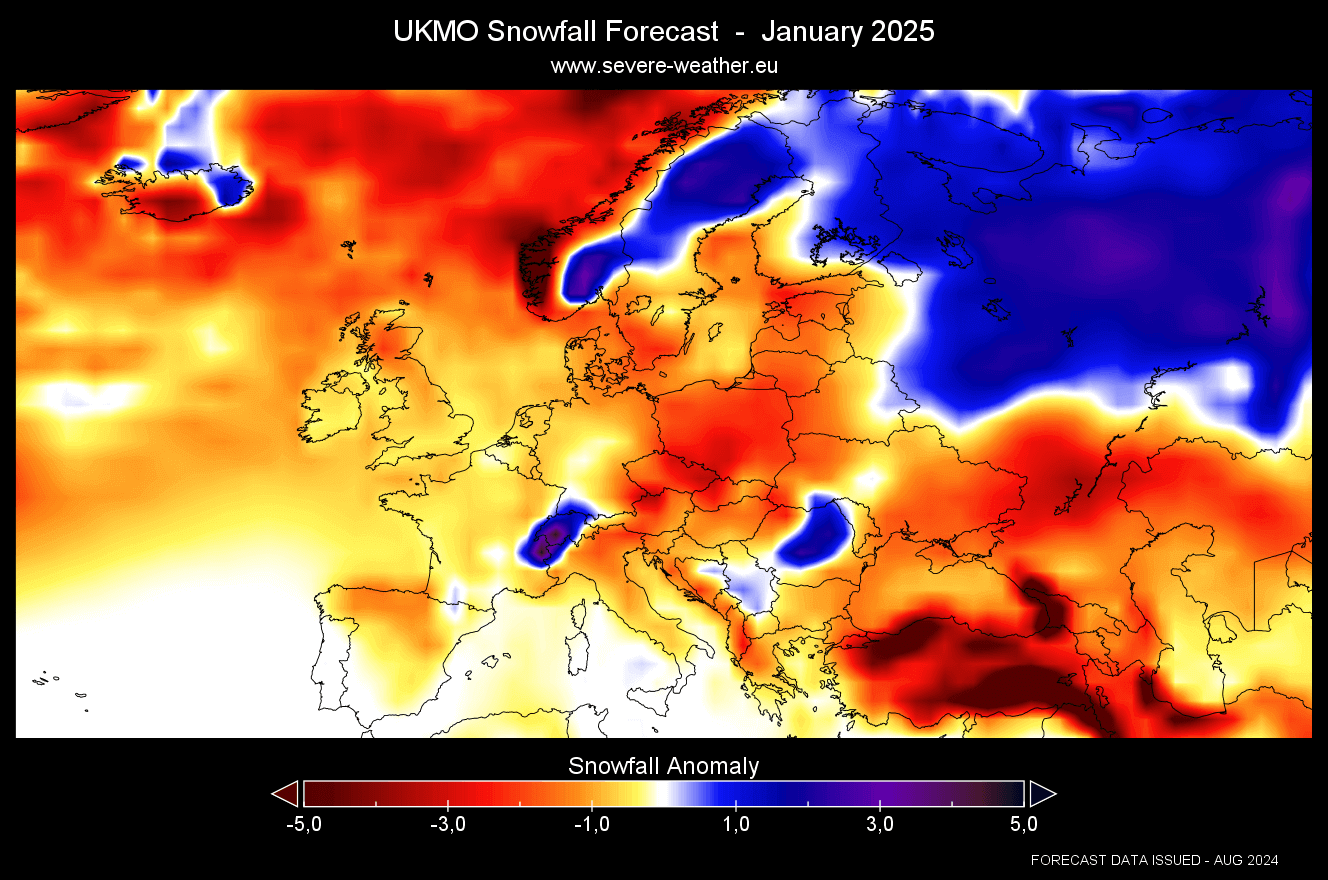
Overall, both models agree on a weak snowfall season over Europe, except for the northern areas and some central parts around the Alps.
NORTH AMERICA UKMO SNOWFALL PREDICTION
The average seasonal forecast for North America shows more snowfall potential across the northwestern United States and western Canada. Less snowfall is forecast over much of the southern and eastern United States and over deep southeastern Canada.

The November snowfall forecast shows less snowfall than normal over much of southern Canada, northeastern United States, and the upper Midwest. You can see more snowfall over the northwestern United States and even over the Ohio River Basin.

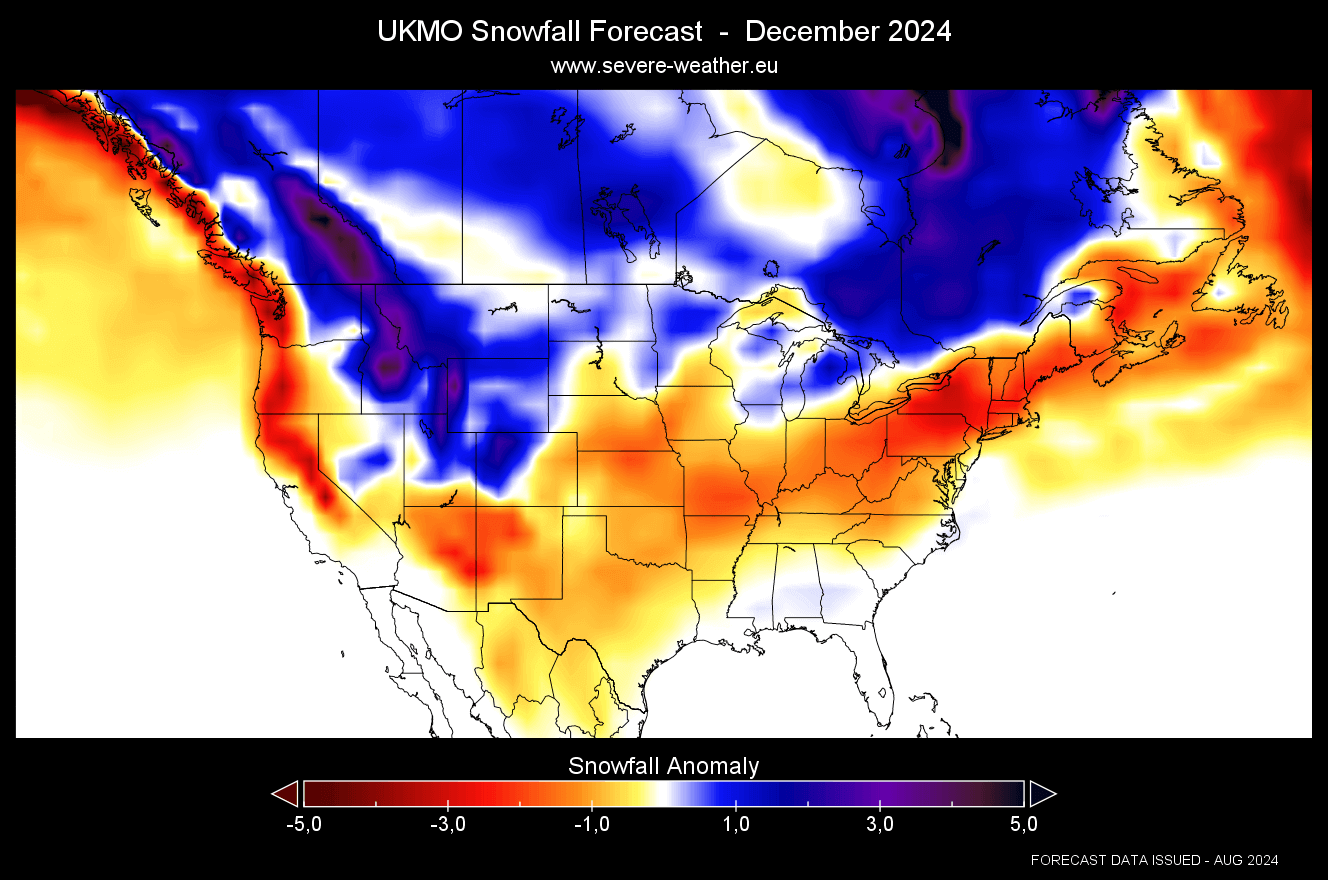
The December snowfall forecast shows more snowfall over much of Canada and the northwestern United States. UKMO forecast also shows more snowfall than usual over the upper Midwest and around the Great Lakes. Less snowfall is forecast over the Northeastern United States and the plains.
January snowfall forecast shows increased snowfall amounts over much of Canada and the northwestern United States. But you can also see an area of more snowfall over the Midwest. Surprisingly, despite a weak La Niña, the northeastern United States is still forecast with less snowfall than usual.

This is a different forecast from the ECMWF, but that is to be expected as the forecast length increases. In the next update, we will have full Winter data with February included, giving a better image over the entire Winter season.
Also, the La Niña event should be more developed in the Ocean and thus also more “present” in the atmosphere in September, improving the overall forecast quality of the next model runs.
Also, we will keep you updated on other developing weather trends, so bookmark our page. Also, if you have seen this article in the Google App (Discover) feed, click the like button (♥) there to see more of our forecasts and our latest articles on weather and nature in general.
Don’t miss:
Winter Forecast 2024/2025: First long-range Predictions from Seasonal Weather models